TopoQuest Logo
Do you find TopoQuest useful?
Help keep TopoQuest running and adding new maps/features by donating!
Bitcoin:  19c7KJd3qBynnjoSw5npx9KScwjBe4ifkT
Litecoin:  LXs6TkuXGGXo1vDsWCkWVdjQX94eUKd6ui
Home View Maps Find Maps Find Places Resources & Links


Bell Peak, New Mexico Topographic Map

USGS Map Title: Bell Peak, NM
USGS Map MRC: 33108H3
DRG (GeoTIFF) Download: o33108h3.tif


Neighboring USGS Topographic Map Quads:


  Slaughter Mesa, NM  
34108A4
 

  Mangas Mountain, NM  
34108A3
 

  Wallace Mesa, NM  
34108A2
 

  Tularosa Canyon, NM  
33108H4
 

  Bell Peak, NM  
33108H3
 

  Horse Mountain West, NM  
33108H2
 

  John Kerr Peak, NM  
33108G4
 

  Rael Spring, NM  
33108G3
 

  Fullerton, NM  
33108G2


Map MRC Location:

N34°
W109°
N34°
W108°
H8 H7 H6 H5 H4 H3 H2 H1
G8 G7 G6 G5 G4 G3 G2 G1
F8 F7 F6 F5 F4 F3 F2 F1
E8 E7 E6 E5 E4 E3 E2 E1
D8 D7 D6 D5 D4 D3 D2 D1
C8 C7 C6 C5 C4 C3 C2 C1
B8 B7 B6 B5 B4 B3 B2 B1
A8 A7 A6 A5 A4 A3 A2 A1
N33°
W109°
N33°
W108°

Bell Peak, NM USGS 1:24K Topographic Map Preview:
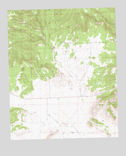
Bell Peak, NM USGS Topographic Map
Click on map above to begin viewing in our Map Viewer.

This topographic map contains these locations and features:
Feature Name Type Latitude Longitude GNIS ID View Map
Barreras CanyonValleyN33.9712°W108.3326°1923088View Map
Bell PeakSummitN33.9628°W108.3234°1848341View Map
Carrejo TankReservoirN33.9885°W108.3182°1848345View Map
Celeo WellWellN33.9359°W108.3651°1848342View Map
Cross RidgeRidgeN33.9867°W108.3356°2038425View Map
Dark CanyonValleyN33.8889°W108.3095°1848333View Map
East Sanchez TankReservoirN33.9677°W108.2520°1848340View Map
Flat RidgeRidgeN33.9881°W108.2939°1848335View Map
Francisco TankReservoirN33.9578°W108.3412°1848346View Map
Gallina CanyonValleyN33.9989°W108.3317°1848349View Map
Gate TankReservoirN33.9954°W108.3196°1848339View Map
Jaramillo RanchLocaleN33.9034°W108.3312°898922View Map
Ladies CanyonValleyN33.9826°W108.3295°1853998View Map
Lady TankReservoirN33.9834°W108.3298°936725View Map
Landing Camp CanyonValleyN33.9551°W108.3242°1848343View Map
Loco TankReservoirN33.8913°W108.2691°1848338View Map
Lower Barreras TankReservoirN33.9729°W108.3377°1848347View Map
Manuel TankReservoirN33.9818°W108.3031°1848350View Map
Paterson SpringSpringN33.8864°W108.3006°902776View Map
Patterson CanyonValleyN33.8937°W108.3062°1848348View Map
Patterson LakeReservoirN33.8806°W108.3016°1848337View Map
Plains of San AgustinAreaN33.8753°W108.2509°923769View Map
Plains of San Augustin Historical MarkerParkN33.8753°W108.2509°931698View Map
Rincon CanyonValleyN33.9020°W108.2989°1848336View Map
Sotolee SpringSpringN33.8863°W108.3033°902569View Map
Todd Water WellWellN33.9006°W108.3484°919661View Map
Upper Barreras TankReservoirN33.9819°W108.3732°1848344View Map
Well A-1 Water WellWellN33.9023°W108.3312°919678View Map
West Boundary TankReservoirN33.9673°W108.3088°1848334View Map

Note: Coordinates in the location and feature list above are referenced to NAD83 datum.


Copyright (C) 2008-2024 Ryan Niemi / Sunset Dynamics ... All Rights Reserved