TopoQuest Logo
Do you find TopoQuest useful?
Help keep TopoQuest running and adding new maps/features by donating!
Bitcoin:  19c7KJd3qBynnjoSw5npx9KScwjBe4ifkT
Litecoin:  LXs6TkuXGGXo1vDsWCkWVdjQX94eUKd6ui
Home View Maps Find Maps Find Places Resources & Links


Slaughter Mesa, New Mexico Topographic Map

USGS Map Title: Slaughter Mesa, NM
USGS Map MRC: 34108A4
DRG (GeoTIFF) Download: o34108a4.tif


Neighboring USGS Topographic Map Quads:


  Largo Mesa, NM  
34108B5
 

  Escondido Mountain, NM  
34108B4
 

  Mangas, NM  
34108B3
 

  Gallo Mountains East, NM  
34108A5
 

  Slaughter Mesa, NM  
34108A4
 

  Mangas Mountain, NM  
34108A3
 

  Aragon, NM  
33108H5
 

  Tularosa Canyon, NM  
33108H4
 

  Bell Peak, NM  
33108H3


Map MRC Location:

N35°
W109°
N35°
W108°
H8 H7 H6 H5 H4 H3 H2 H1
G8 G7 G6 G5 G4 G3 G2 G1
F8 F7 F6 F5 F4 F3 F2 F1
E8 E7 E6 E5 E4 E3 E2 E1
D8 D7 D6 D5 D4 D3 D2 D1
C8 C7 C6 C5 C4 C3 C2 C1
B8 B7 B6 B5 B4 B3 B2 B1
A8 A7 A6 A5 A4 A3 A2 A1
N34°
W109°
N34°
W108°

Slaughter Mesa, NM USGS 1:24K Topographic Map Preview:
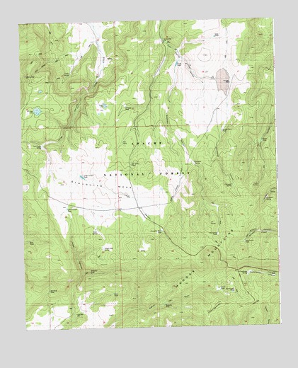
Slaughter Mesa, NM USGS Topographic Map
Click on map above to begin viewing in our Map Viewer.

This topographic map contains these locations and features:
Feature Name Type Latitude Longitude GNIS ID View Map
Antelope TankReservoirN34.0901°W108.4490°1877561View Map
Bluestem TankReservoirN34.0226°W108.4676°1923296View Map
Bull TankReservoirN34.0362°W108.4973°1923291View Map
Caballeriza SpringSpringN34.0217°W108.3909°1923286View Map
Caballeriza TankReservoirN34.0203°W108.3772°1923285View Map
Cassidera SpringSpringN34.0514°W108.3812°1923283View Map
Cat SpringSpringN34.0420°W108.4084°1923284View Map
Cat Spring TankReservoirN34.0378°W108.4052°1923275View Map
Chimenea CanyonValleyN34.0792°W108.4020°1923280View Map
Chimenea SpringSpringN34.0578°W108.3973°1923278View Map
Continental TankReservoirN34.0139°W108.3981°1923287View Map
Cooper Seep SpringSpringN34.0326°W108.4609°1923295View Map
Dead Horse CanyonValleyN34.0806°W108.4276°1923302View Map
Divide TankReservoirN34.0148°W108.4053°1923288View Map
Dry Lake WellWellN34.0992°W108.3976°1877562View Map
East TankReservoirN34.0142°W108.4578°1923299View Map
El Caso LakeLakeN34.0891°W108.4921°1923260View Map
El Caso LookoutLocaleN34.1031°W108.4948°936626View Map
Elk TankReservoirN34.0026°W108.4259°2038456View Map
Fire TankReservoirN34.0756°W108.4506°1923276View Map
Gooseberry PitReservoirN34.1167°W108.4295°1877573View Map
Green TankReservoirN34.0759°W108.3826°1923281View Map
Hell Hole TankReservoirN34.0156°W108.4879°1923297View Map
Indio Canyon TankReservoirN34.0490°W108.4785°1923294View Map
Jacobs Camp TankReservoirN34.0797°W108.4017°1923279View Map
Lake PitBasinN34.0906°W108.4590°1934800View Map
Largo CanyonValleyN34.1028°W108.4617°1923290View Map
Largo Canyon TankReservoirN34.0618°W108.4708°2038534View Map
Leslie SpringSpringN34.1039°W108.4759°1923263View Map
Leslie Spring TrailTrailN34.1117°W108.4756°1923261View Map
Lobo TankReservoirN34.1181°W108.4042°1877563View Map
Lost Cabin WellWellN34.0059°W108.4751°1923298View Map
Lyles Camp SpringSpringN34.0745°W108.4912°1934600View Map
Mangas MountainsRangeN34.0098°W108.3834°920640View Map
McKibben TankReservoirN34.0665°W108.4466°1923303View Map
Mestenio TankReservoirN34.0093°W108.4315°1923300View Map
North TankReservoirN34.1081°W108.4228°1877564View Map
Salvador CanyonValleyN34.1098°W108.4215°1877565View Map
Salvador SpringSpringN34.0670°W108.4159°1923277View Map
San Antone TankReservoirN34.0342°W108.3920°1923289View Map
Slaughter MesaSummitN34.0623°W108.4392°911130View Map
Slaughter Mesa TankReservoirN34.0393°W108.4324°1923301View Map
Twin SpringsSpringN34.0401°W108.4651°1923293View Map
Verde SpringSpringN34.0573°W108.3845°1923282View Map

Note: Coordinates in the location and feature list above are referenced to NAD83 datum.


Copyright (C) 2008-2025 Ryan Niemi / Sunset Dynamics ... All Rights Reserved