TopoQuest Logo
Do you find TopoQuest useful?
Help keep TopoQuest running and adding new maps/features by donating!
Bitcoin:  19c7KJd3qBynnjoSw5npx9KScwjBe4ifkT
Litecoin:  LXs6TkuXGGXo1vDsWCkWVdjQX94eUKd6ui
Home View Maps Find Maps Find Places Resources & Links


Bellaire, Michigan Topographic Map

USGS Map Title: Bellaire, MI
USGS Map MRC: 44085H2
DRG (GeoTIFF) Download: o44085h2.tif


Neighboring USGS Topographic Map Quads:


  Bellaire, MI  
44085H2
 

  Mancelona, MI  
44085H1


  Leetsville, MI  
44085G2
 

  Westwood, MI  
44085G1


Map MRC Location:

N45°
W86°
N45°
W85°
H8 H7 H6 H5 H4 H3 H2 H1
G8 G7 G6 G5 G4 G3 G2 G1
F8 F7 F6 F5 F4 F3 F2 F1
E8 E7 E6 E5 E4 E3 E2 E1
D8 D7 D6 D5 D4 D3 D2 D1
C8 C7 C6 C5 C4 C3 C2 C1
B8 B7 B6 B5 B4 B3 B2 B1
A8 A7 A6 A5 A4 A3 A2 A1
N44°
W86°
N44°
W85°

Bellaire, MI USGS 1:24K Topographic Map Preview:
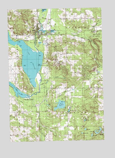
Bellaire, MI USGS Topographic Map
Click on map above to begin viewing in our Map Viewer.

This topographic map contains these locations and features:
Feature Name Type Latitude Longitude GNIS ID View Map
Allied Emergency Medical Services Bellaire StationBuildingN44.9711°W85.1976°2661951View Map
Antrim County AirportAirportN44.9866°W85.1992°1623799View Map
Antrim County CourthouseBuildingN44.9761°W85.2081°2463783View Map
Antrim County Sheriff's OfficeBuildingN44.9760°W85.2086°2463693View Map
Bates LakeLakeN44.8940°W85.1503°620738View Map
BellairePopulated PlaceN44.9803°W85.2112°621048View Map
Bellaire Area Historical Society and MuseumBuildingN44.9769°W85.2094°2463690View Map
Bellaire Country ClubLocaleN44.9386°W85.1984°1623233View Map
Bellaire DamDamN44.9792°W85.2086°2463251View Map
Bellaire District Fire DepartmentBuildingN44.9768°W85.1944°2626729View Map
Bellaire Family Health CenterHospitalN44.9758°W85.2058°2463692View Map
Bellaire Golf ClubLocaleN44.9408°W85.1958°2463705View Map
Bellaire High SchoolSchoolN44.9819°W85.2122°2463710View Map
Bellaire Police DepartmentBuildingN44.9767°W85.2096°2463691View Map
Bellaire Post OfficePost OfficeN44.9783°W85.2108°2463687View Map
Bellaire Public LibraryBuildingN44.9747°W85.2097°2463689View Map
Bellaire Station (historical)LocaleN44.9761°W85.2058°2463686View Map
Bellaire United Methodist ChurchChurchN44.9803°W85.2106°2463696View Map
Bellaire Wesleyan ChurchChurchN44.9753°W85.2089°2463695View Map
Bellaire-Antrim County Seat Historical MarkerParkN44.9753°W85.2081°2463784View Map
Blair LakeReservoirN44.9787°W85.1908°621560View Map
Boat LakeLakeN44.9160°W85.1376°621667View Map
Browning LakeLakeN44.8818°W85.1544°622103View Map
Cedar RiverStreamN44.9800°W85.2045°622946View Map
Cedar River Golf ClubLocaleN44.9506°W85.1478°2463701View Map
Centennial Farm Golf ClubLocaleN44.9950°W85.1597°2463709View Map
Chain-O-Lakes CampgroundLocaleN44.9250°W85.1900°2463704View Map
Chapman CemeteryCemeteryN44.8886°W85.1692°623096View Map
Chief Golf CourseLocaleN44.9642°W85.1833°2463708View Map
Cold CreekStreamN44.9250°W85.2089°623556View Map
Comfort Station (historical)LocaleN44.9097°W85.2086°2463574View Map
Cornerstone ChurchChurchN44.9667°W85.1472°2463703View Map
Craven ParkParkN44.9761°W85.1906°624026View Map
Crow CreekStreamN44.8889°W85.2087°624136View Map
Custer Township HallBuildingN44.9033°W85.1514°2463641View Map
Custer Township ParkParkN44.9047°W85.1756°2463640View Map
Fairview CemeteryCemeteryN44.9247°W85.1842°625771View Map
Finch CreekStreamN44.9147°W85.2228°625951View Map
Finn LakeLakeN44.9037°W85.1709°625966View Map
First Baptist ChurchChurchN44.9778°W85.2100°2463694View Map
Forest Home Township HallBuildingN44.9781°W85.2100°2463688View Map
Grass RiverStreamN44.9172°W85.2228°627223View Map
Green LakeLakeN44.8819°W85.1346°627309View Map
Hawk's Eye Golf ClubLocaleN44.9617°W85.1500°2463702View Map
Henry LakeLakeN44.8819°W85.1252°628123View Map
Hope Lutheran of BellaireChurchN44.9950°W85.2106°2463698View Map
Intermediate RiverStreamN44.9597°W85.2106°629056View Map
Lake ArthurLakeN44.8798°W85.1413°1617065View Map
Lake BellaireLakeN44.9527°W85.2234°621049View Map
Lake of the WoodsLakeN44.9087°W85.1824°1616798View Map
Lakeview CemeteryCemeteryN44.9761°W85.2298°630055View Map
Legend Golf ClubLocaleN44.9542°W85.1806°2463707View Map
Meadow Brook HospitalHospitalN44.9675°W85.1984°632047View Map
Meadowbrook Medical Care FacilityHospitalN44.9672°W85.1972°2463699View Map
Michigan Department of Natural Resources Bellaire Field OfficeBuildingN44.9758°W85.1977°2626982View Map
Morey CemeteryCemeteryN44.9572°W85.1831°632678View Map
Mud LakeLakeN44.8959°W85.1541°633003View Map
North ArmsPopulated PlaceN44.9711°W85.2315°633470View Map
North Branch Cedar RiverStreamN44.9761°W85.1506°633497View Map
Richardi ParkParkN44.9794°W85.2097°2463252View Map
Rootville Post Office (historical)Post OfficeN44.9278°W85.2417°2463584View Map
Saint Luke's Catholic ChurchChurchN44.9886°W85.2114°2463697View Map
Saloon CreekStreamN44.9136°W85.1873°637133View Map
Schuss Mountain Golf ClubLocaleN44.9339°W85.1361°2463700View Map
Schuss Mountain Ski AreaLocaleN44.9403°W85.1333°2463684View Map
Shanty CreekStreamN44.9281°W85.2092°637662View Map
Shanty Creek Ski AreaLocaleN44.9483°W85.1847°2463685View Map
Smith LakeLakeN44.8854°W85.1500°638165View Map
Stover PondReservoirN44.9553°W85.1348°638932View Map
Summit Golf ClubLocaleN44.9500°W85.1903°2463706View Map
Township of CusterCivilN44.9024°W85.1511°1626151View Map
Township of KearneyCivilN44.9906°W85.1517°1626553View Map
Trestle BridgeBridgeN44.9800°W85.2064°2463253View Map
Village of BellaireCivilN44.9737°W85.2057°2398074View Map
William A Hosmer ParkParkN44.9750°W85.2064°2463782View Map
Woolcott CreekStreamN44.9747°W85.1381°1616815View Map

Note: Coordinates in the location and feature list above are referenced to NAD83 datum.


Copyright (C) 2008-2025 Ryan Niemi / Sunset Dynamics ... All Rights Reserved