TopoQuest Logo
Do you find TopoQuest useful?
Help keep TopoQuest running and adding new maps/features by donating!
Bitcoin:  19c7KJd3qBynnjoSw5npx9KScwjBe4ifkT
Litecoin:  LXs6TkuXGGXo1vDsWCkWVdjQX94eUKd6ui
Home View Maps Find Maps Find Places Resources & Links


Belle, Missouri Topographic Map

USGS Map Title: Belle, MO
USGS Map MRC: 38091C6
DRG (GeoTIFF) Download: o38091c6.tif


Neighboring USGS Topographic Map Quads:


  Linn, MO  
38091D7
 

  Cooper Hill, MO  
38091D6
 

  Goerlisch Ridge, MO  
38091D5
 

  Summerfield, MO  
38091C7
 

  Belle, MO  
38091C6
 

  Owensville West, MO  
38091C5
 

  Paydown, MO  
38091B7
 

  High Gate, MO  
38091B6
 

  Redbird, MO  
38091B5


Map MRC Location:

N39°
W92°
N39°
W91°
H8 H7 H6 H5 H4 H3 H2 H1
G8 G7 G6 G5 G4 G3 G2 G1
F8 F7 F6 F5 F4 F3 F2 F1
E8 E7 E6 E5 E4 E3 E2 E1
D8 D7 D6 D5 D4 D3 D2 D1
C8 C7 C6 C5 C4 C3 C2 C1
B8 B7 B6 B5 B4 B3 B2 B1
A8 A7 A6 A5 A4 A3 A2 A1
N38°
W92°
N38°
W91°

Belle, MO USGS 1:24K Topographic Map Preview:
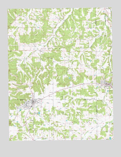
Belle, MO USGS Topographic Map
Click on map above to begin viewing in our Map Viewer.

This topographic map contains these locations and features:
Feature Name Type Latitude Longitude GNIS ID View Map
Adkins SchoolSchoolN38.2667°W91.6721°713158View Map
BellePopulated PlaceN38.2859°W91.7204°713921View Map
Belle Police DepartmentBuildingN38.2869°W91.7199°2752437View Map
Belle Volunteer Fire DepartmentBuildingN38.2866°W91.7170°2621425View Map
Beulah ChurchChurchN38.2673°W91.6727°741881View Map
BlandPopulated PlaceN38.3017°W91.6329°714352View Map
Bland Police DepartmentBuildingN38.3031°W91.6324°2752430View Map
Bland Post OfficePost OfficeN38.3034°W91.6350°2782771View Map
Bland Volunteer Fire Department Station 1BuildingN38.3040°W91.6350°2620314View Map
Bumpass CreekStreamN38.3353°W91.7166°738008View Map
ByronPopulated PlaceN38.3353°W91.7107°729286View Map
Campbell CemeteryCemeteryN38.2587°W91.6728°715307View Map
City of BelleCivilN38.2849°W91.7218°2394112View Map
City of BlandCivilN38.3004°W91.6331°2394190View Map
Clear ForkStreamN38.3575°W91.6321°738006View Map
Crider CemeteryCemeteryN38.2734°W91.6296°741879View Map
Crossroads SchoolSchoolN38.2678°W91.7285°716538View Map
Dingley (historical)Populated PlaceN38.3012°W91.6807°738716View Map
Dingley SchoolSchoolN38.2998°W91.6724°716910View Map
Francis CemeteryCemeteryN38.3264°W91.7360°718160View Map
Gallaway StationBuildingN38.2898°W91.7110°743832View Map
Garfield School (historical)SchoolN38.3575°W91.7324°718344View Map
Hedenkamp Lake DamDamN38.2517°W91.6285°765226View Map
Heyer CemeteryCemeteryN38.3242°W91.6971°741884View Map
Klein BranchStreamN38.2514°W91.7174°738007View Map
Liberty CemeteryCemeteryN38.2606°W91.7268°720965View Map
Liberty ChurchChurchN38.2603°W91.7260°741882View Map
McKinley SchoolSchoolN38.3175°W91.7271°722145View Map
Mount Zion Baptist ChurchChurchN38.3256°W91.6788°741885View Map
Mount Zion SchoolSchoolN38.3256°W91.6760°722983View Map
Old Bland CemeteryCemeteryN38.3125°W91.6263°741880View Map
Pepper FieldAirportN38.3009°W91.6892°2679298View Map
Skillet HollowValleyN38.3637°W91.7271°726510View Map
Township of JeffersonCivilN38.3534°W91.7314°767120View Map
Travis CemeteryCemeteryN38.2520°W91.7290°741883View Map
Weller School (historical)SchoolN38.3528°W91.6746°729409View Map

Note: Coordinates in the location and feature list above are referenced to NAD83 datum.


Copyright (C) 2008-2024 Ryan Niemi / Sunset Dynamics ... All Rights Reserved