TopoQuest Logo
Do you find TopoQuest useful?
Help keep TopoQuest running and adding new maps/features by donating!
Bitcoin:  19c7KJd3qBynnjoSw5npx9KScwjBe4ifkT
Litecoin:  LXs6TkuXGGXo1vDsWCkWVdjQX94eUKd6ui
Home View Maps Find Maps Find Places Resources & Links


Owensville West, Missouri Topographic Map

USGS Map Title: Owensville West, MO
USGS Map MRC: 38091C5
DRG (GeoTIFF) Download: o38091c5.tif


Neighboring USGS Topographic Map Quads:


  Cooper Hill, MO  
38091D6
 

  Goerlisch Ridge, MO  
38091D5
 

  Rosebud, MO  
38091D4
 

  Belle, MO  
38091C6
 

  Owensville West, MO  
38091C5
 

  Owensville East, MO  
38091C4
 

  High Gate, MO  
38091B6
 

  Redbird, MO  
38091B5
 

  Oak Hill, MO  
38091B4


Map MRC Location:

N39°
W92°
N39°
W91°
H8 H7 H6 H5 H4 H3 H2 H1
G8 G7 G6 G5 G4 G3 G2 G1
F8 F7 F6 F5 F4 F3 F2 F1
E8 E7 E6 E5 E4 E3 E2 E1
D8 D7 D6 D5 D4 D3 D2 D1
C8 C7 C6 C5 C4 C3 C2 C1
B8 B7 B6 B5 B4 B3 B2 B1
A8 A7 A6 A5 A4 A3 A2 A1
N38°
W92°
N38°
W91°

Owensville West, MO USGS 1:24K Topographic Map Preview:
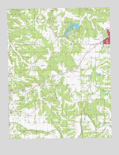
Owensville West, MO USGS Topographic Map
Click on map above to begin viewing in our Map Viewer.

This topographic map contains these locations and features:
Feature Name Type Latitude Longitude GNIS ID View Map
Barbarick School (historical)SchoolN38.3550°W91.6210°744393View Map
Boettcher SchoolSchoolN38.3548°W91.5710°714477View Map
Branson CemeteryCemeteryN38.3732°W91.5691°741872View Map
Brush CreekStreamN38.2655°W91.5385°714835View Map
CanaanPopulated PlaceN38.3123°W91.5590°715325View Map
Canaan Census Designated PlaceCensusN38.3133°W91.5559°2587057View Map
Canaan Conservation AreaForestN38.3375°W91.6017°2093247View Map
Catholic CemeteryCemeteryN38.2759°W91.6213°741878View Map
Cave HollowValleyN38.3717°W91.6238°715523View Map
CleavesvillePopulated PlaceN38.2728°W91.6018°715960View Map
Cleavesville SchoolSchoolN38.2731°W91.6149°715961View Map
Countryside Memorial GardensCemeteryN38.3139°W91.5478°738003View Map
Douglas HollowValleyN38.3306°W91.5988°738004View Map
Fairview Field (historical)AirportN38.3584°W91.5085°758845View Map
Howard CemeteryCemeteryN38.2889°W91.5835°741877View Map
Jasper Lake DamDamN38.2684°W91.5618°765282View Map
KZBR-FM (Owensville)TowerN38.2562°W91.5346°759074View Map
Liberty ChurchChurchN38.3192°W91.5404°741875View Map
Lone Ridge SchoolSchoolN38.3128°W91.5088°721458View Map
McGowen Lake DamDamN38.2934°W91.5052°764532View Map
New Bethel ChurchChurchN38.3739°W91.6015°729574View Map
Nubbin Ridge CemeteryCemeteryN38.3736°W91.6017°2746101View Map
Old BlandPopulated PlaceN38.3150°W91.6229°723716View Map
Old Bland CreekStreamN38.3406°W91.6227°738184View Map
Old Bland School (historical)SchoolN38.3114°W91.6238°744394View Map
Old United Methodist CemeteryCemeteryN38.3284°W91.6038°741876View Map
OwensvillePopulated PlaceN38.3456°W91.5015°723913View Map
Owensville City Police DepartmentBuildingN38.3482°W91.5013°2752528View Map
Owensville Post OfficePost OfficeN38.3453°W91.5021°2782843View Map
Owensville Volunteer Fire Department Main StationBuildingN38.3413°W91.5103°2621022View Map
Peaceful Valley LakeReservoirN38.3589°W91.5465°758379View Map
Peaceful Valley Lake DamDamN38.3600°W91.5385°763873View Map
Richardson CemeteryCemeteryN38.3267°W91.5184°741874View Map
Rockhouse HollowValleyN38.3728°W91.6235°725484View Map
Shockley Lake DamDamN38.2584°W91.5502°765283View Map
Sulphur BranchStreamN38.3437°W91.6227°738005View Map
Township of ClayCivilN38.2954°W91.5816°766660View Map
Trampe Lake DamDamN38.3100°W91.5102°764598View Map
Union CemeteryCemeteryN38.2935°W91.6221°727970View Map
United Methodist ChurchChurchN38.3639°W91.5716°741873View Map
Wallace SchoolSchoolN38.2617°W91.5638°729681View Map
Winter Field Airport (historical)AirportN38.3393°W91.5194°758844View Map

Note: Coordinates in the location and feature list above are referenced to NAD83 datum.


Copyright (C) 2008-2024 Ryan Niemi / Sunset Dynamics ... All Rights Reserved