TopoQuest Logo
Do you find TopoQuest useful?
Help keep TopoQuest running and adding new maps/features by donating!
Bitcoin:  19c7KJd3qBynnjoSw5npx9KScwjBe4ifkT
Litecoin:  LXs6TkuXGGXo1vDsWCkWVdjQX94eUKd6ui
Home View Maps Find Maps Find Places Resources & Links


Princeton East, Wisconsin Topographic Map

USGS Map Title: Princeton East, WI
USGS Map MRC: 43089G1
DRG (GeoTIFF) Download: o43089g1.tif


Neighboring USGS Topographic Map Quads:


  Neshkoro, WI  
43089H2
 

  Fairburn, WI  
43089H1
 

  Berlin, WI  
43088H8
 

  Princeton West, WI  
43089G2
 

  Princeton East, WI  
43089G1
 

  Green Lake, WI  
43088G8
 

  Marquette, WI  
43089F2
 

  Manchester, WI  
43089F1
 

  Markesan, WI  
43088F8


Map MRC Location:

N44°
W90°
N44°
W89°
H8 H7 H6 H5 H4 H3 H2 H1
G8 G7 G6 G5 G4 G3 G2 G1
F8 F7 F6 F5 F4 F3 F2 F1
E8 E7 E6 E5 E4 E3 E2 E1
D8 D7 D6 D5 D4 D3 D2 D1
C8 C7 C6 C5 C4 C3 C2 C1
B8 B7 B6 B5 B4 B3 B2 B1
A8 A7 A6 A5 A4 A3 A2 A1
N43°
W90°
N43°
W89°

Princeton East, WI USGS 1:24K Topographic Map Preview:
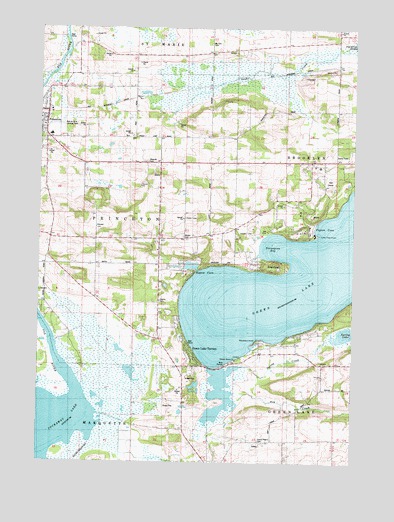
Princeton East, WI USGS Topographic Map
Click on map above to begin viewing in our Map Viewer.

This topographic map contains these locations and features:
Feature Name Type Latitude Longitude GNIS ID View Map
Bed-Ah-Wick Field (historical)AirportN43.8500°W89.1168°1581046View Map
Beyers CoveBayN43.8064°W89.0632°1561669View Map
Blackbird PointCapeN43.7836°W89.0398°1561894View Map
Dayton CemeteryCemeteryN43.7964°W89.0765°1563750View Map
Dickinsons BayBayN43.7916°W89.0096°1843727View Map
Emmanuel United Methodist ChurchChurchN43.8486°W89.1229°1843729View Map
Golf Courses of LawsoniaLocaleN43.8311°W89.0096°1843735View Map
Grand Prairie CemeteryCemeteryN43.7564°W89.0368°1565715View Map
Green LakeLakeN43.8107°W89.0001°1565821View Map
Green Lake Conference CenterBuildingN43.8158°W89.0154°1843742View Map
Green Lake CountyCivilN43.8004°W89.0449°1581083View Map
Green Lake TerracePopulated PlaceN43.7825°W89.0646°1565823View Map
GreenwyckPopulated PlaceN43.7853°W89.0237°1843746View Map
Lakewood EstatesPopulated PlaceN43.7886°W89.0143°1843755View Map
Lone Tree PointCapeN43.8155°W89.0148°1568517View Map
Mount Tom CemeteryCemeteryN43.8705°W89.0568°1569851View Map
Norwegian BayBayN43.8114°W89.0340°1570550View Map
Pigeon CoveBayN43.8189°W89.0123°1571359View Map
Pleasant Valley ChurchChurchN43.8147°W89.0671°1571650View Map
PrincetonPopulated PlaceN43.8508°W89.1218°1571941View Map
Princeton Police DepartmentBuildingN43.8453°W89.1232°2759716View Map
Princeton SchoolSchoolN43.8442°W89.1207°1843765View Map
Quimby BayBayN43.8036°W89.0604°1843768View Map
Roy CreekStreamN43.7675°W89.0459°1572696View Map
School Number 1 (historical)SchoolN43.7572°W89.0071°1843786View Map
School Number 11 (historical)SchoolN43.8103°W89.1209°1843806View Map
School Number 12 (historical)SchoolN43.8041°W89.0779°1843808View Map
School Number 2 (historical)SchoolN43.8369°W89.0173°1843788View Map
School Number 3 (historical)SchoolN43.8680°W89.1001°1843791View Map
School Number 5 (historical)SchoolN43.8728°W89.0568°1843795View Map
School Number 6 (historical)SchoolN43.8364°W89.0784°1843799View Map
School Number 8 (historical)SchoolN43.7819°W89.0226°1843804View Map
Snake CreekStreamN43.8691°W89.0001°1574331View Map
Snake Creek Fen State Natural AreaParkN43.8619°W89.0329°2057275View Map
Spring CreekStreamN43.7755°W89.0493°1574613View Map
Spring LakeLakeN43.7873°W89.0025°1574687View Map
SugarloafCapeN43.8061°W89.0262°1575036View Map
Sylvan ShoresPopulated PlaceN43.8069°W89.0382°1843816View Map
Terrace Shores Evangelical Free ChurchChurchN43.7794°W89.0465°1843817View Map
Town of BrooklynCivilN43.8247°W89.0233°1582871View Map
Town of PrincetonCivilN43.8297°W89.1213°1583987View Map
Weiser CemeteryCemeteryN43.8147°W89.0679°1843822View Map

Note: Coordinates in the location and feature list above are referenced to NAD83 datum.


Copyright (C) 2008-2024 Ryan Niemi / Sunset Dynamics ... All Rights Reserved