TopoQuest Logo
Do you find TopoQuest useful?
Help keep TopoQuest running and adding new maps/features by donating!
Bitcoin:  19c7KJd3qBynnjoSw5npx9KScwjBe4ifkT
Litecoin:  LXs6TkuXGGXo1vDsWCkWVdjQX94eUKd6ui
Home View Maps Find Maps Find Places Resources & Links


Nevils, Georgia Topographic Map

USGS Map Title: Nevils, GA
USGS Map MRC: 32081C7
DRG (GeoTIFF) Download: o32081c7.tif


Neighboring USGS Topographic Map Quads:


  Pulaski, GA  
32081D8
 

  Statesboro, GA  
32081D7
 

  Brooklet, GA  
32081D6
 

  Register, GA  
32081C8
 

  Nevils, GA  
32081C7
 

  Denmark, GA  
32081C6
 

  Claxton, GA  
32081B8
 

  Daisy, GA  
32081B7
 

  Groveland, GA  
32081B6


Map MRC Location:

N33°
W82°
N33°
W81°
H8 H7 H6 H5 H4 H3 H2 H1
G8 G7 G6 G5 G4 G3 G2 G1
F8 F7 F6 F5 F4 F3 F2 F1
E8 E7 E6 E5 E4 E3 E2 E1
D8 D7 D6 D5 D4 D3 D2 D1
C8 C7 C6 C5 C4 C3 C2 C1
B8 B7 B6 B5 B4 B3 B2 B1
A8 A7 A6 A5 A4 A3 A2 A1
N32°
W82°
N32°
W81°

Nevils, GA USGS 1:24K Topographic Map Preview:
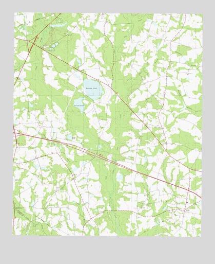
Nevils, GA USGS Topographic Map
Click on map above to begin viewing in our Map Viewer.

This topographic map contains these locations and features:
Feature Name Type Latitude Longitude GNIS ID View Map
Booth PondLakeN32.3060°W81.8372°311658View Map
Brannen-Wilson CemeteryCemeteryN32.3724°W81.8159°350294View Map
Dam BranchStreamN32.3341°W81.7990°313269View Map
Delmus Rushing LakeReservoirN32.2876°W81.8340°341087View Map
Delmus Rushing Lake DamDamN32.2885°W81.8315°341086View Map
Enal (historical)Populated PlaceN32.3016°W81.7765°350339View Map
Ephesus CemeteryCemeteryN32.2663°W81.8740°350342View Map
Ephesus Old Line ChurchChurchN32.2652°W81.8732°355714View Map
Ewell Pond School (historical)SchoolN32.3160°W81.7609°350344View Map
Exit 25CrossingN32.3077°W81.8740°1704977View Map
Groover Pond (historical)ReservoirN32.3280°W81.8007°350362View Map
Gum BranchStreamN32.3135°W81.8012°314953View Map
Harmony ChurchChurchN32.3419°W81.7604°315142View Map
Hickman PondReservoirN32.3477°W81.8317°341514View Map
Hickman Pond DamDamN32.3468°W81.8315°341513View Map
Hodges PondReservoirN32.2831°W81.8038°341520View Map
Hodges Pond DamDamN32.2835°W81.8065°341519View Map
Kennedy CemeteryCemeteryN32.3018°W81.7690°350375View Map
Kennedy PondReservoirN32.3326°W81.8221°316385View Map
Kirby BranchStreamN32.2927°W81.8179°316468View Map
Little Lotts CreekStreamN32.2763°W81.8082°317115View Map
Lower Lotts Creek ChurchChurchN32.3555°W81.8551°317464View Map
NevilsPopulated PlaceN32.2638°W81.7609°332479View Map
Nevils - Denmark Fire DepartmentBuildingN32.2659°W81.7590°2604269View Map
Nevils SchoolSchoolN32.2694°W81.7596°350405View Map
Nevils United Methodist ChurchChurchN32.2682°W81.7609°350406View Map
New Corent ChurchChurchN32.2663°W81.7904°319297View Map
Newcastle School (historical)SchoolN32.2752°W81.8387°350409View Map
Reedy Branch School (historical)SchoolN32.2732°W81.7671°350433View Map
Riggs LakeReservoirN32.3668°W81.8515°341516View Map
Riggs Lake DamDamN32.3668°W81.8515°341515View Map
Rimes School (historical)SchoolN32.3335°W81.8096°350436View Map
Rushing Mobile Home ParkPopulated PlaceN32.3608°W81.8681°2502536View Map
Scott Creek BridgeBridgeN32.2580°W81.8623°350444View Map
Smith PondReservoirN32.3227°W81.7612°341522View Map
Smith Pond DamDamN32.3219°W81.7615°341521View Map
Southern Ag AviationAirportN32.3284°W81.7580°351912View Map
Southern Links Golf ClubLocaleN32.3658°W81.7813°2502691View Map
Spring Hill ChurchChurchN32.3632°W81.8396°323424View Map
Sylvester School (historical)SchoolN32.3027°W81.8482°350469View Map
T K Rushing PondReservoirN32.2891°W81.8588°341085View Map
T K Rushing Pond DamDamN32.2902°W81.8582°341084View Map
Tillman PondReservoirN32.3244°W81.8310°342358View Map
Union CemeteryCemeteryN32.2841°W81.8351°350474View Map
Union ChurchChurchN32.2844°W81.8351°324519View Map
Union School (historical)SchoolN32.3127°W81.8746°350476View Map
Waters CemeteryCemeteryN32.3118°W81.7787°350478View Map
Williams PondReservoirN32.3233°W81.8634°341518View Map
Williams Pond DamDamN32.3219°W81.8615°341517View Map
WOTR-FM (Statesboro)TowerN32.2791°W81.7801°352787View Map

Note: Coordinates in the location and feature list above are referenced to NAD83 datum.


Copyright (C) 2008-2024 Ryan Niemi / Sunset Dynamics ... All Rights Reserved