TopoQuest Logo
Do you find TopoQuest useful?
Help keep TopoQuest running and adding new maps/features by donating!
Bitcoin:  19c7KJd3qBynnjoSw5npx9KScwjBe4ifkT
Litecoin:  LXs6TkuXGGXo1vDsWCkWVdjQX94eUKd6ui
Home View Maps Find Maps Find Places Resources & Links


Denmark, Georgia Topographic Map

USGS Map Title: Denmark, GA
USGS Map MRC: 32081C6
DRG (GeoTIFF) Download: o32081c6.tif


Neighboring USGS Topographic Map Quads:


  Statesboro, GA  
32081D7
 

  Brooklet, GA  
32081D6
 

  Leefield, GA  
32081D5
 

  Nevils, GA  
32081C7
 

  Denmark, GA  
32081C6
 

  Stilson, GA  
32081C5
 

  Daisy, GA  
32081B7
 

  Groveland, GA  
32081B6
 

  Lanier, GA  
32081B5


Map MRC Location:

N33°
W82°
N33°
W81°
H8 H7 H6 H5 H4 H3 H2 H1
G8 G7 G6 G5 G4 G3 G2 G1
F8 F7 F6 F5 F4 F3 F2 F1
E8 E7 E6 E5 E4 E3 E2 E1
D8 D7 D6 D5 D4 D3 D2 D1
C8 C7 C6 C5 C4 C3 C2 C1
B8 B7 B6 B5 B4 B3 B2 B1
A8 A7 A6 A5 A4 A3 A2 A1
N32°
W82°
N32°
W81°

Denmark, GA USGS 1:24K Topographic Map Preview:
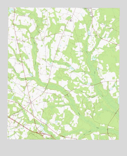
Denmark, GA USGS Topographic Map
Click on map above to begin viewing in our Map Viewer.

This topographic map contains these locations and features:
Feature Name Type Latitude Longitude GNIS ID View Map
Anderson CemeteryCemeteryN32.3218°W81.7376°350284View Map
Antioch Baptist ChurchChurchN32.2990°W81.6254°2502725View Map
Birds BridgeBridgeN32.2602°W81.6371°334622View Map
Brannen School (historical)SchoolN32.3321°W81.6965°334624View Map
Brooklet DivisionCivilN32.3617°W81.6783°1936137View Map
Crombley PondReservoirN32.3513°W81.6591°341073View Map
Crombley Pond DamDamN32.3502°W81.6582°341072View Map
De Loach School (historical)SchoolN32.2960°W81.7459°334626View Map
DenmarkPopulated PlaceN32.2846°W81.7240°313440View Map
Eb Lee FordCrossingN32.2766°W81.6287°334627View Map
EmitPopulated PlaceN32.3438°W81.7398°331662View Map
Emit Grove ChurchChurchN32.3435°W81.7332°313937View Map
Exit 26CrossingN32.2560°W81.7126°1704978View Map
Faith TabernacleChurchN32.3494°W81.6496°314066View Map
Harville Baptist ChurchChurchN32.2743°W81.7229°2502729View Map
High Hope SchoolSchoolN32.2966°W81.7471°315387View Map
Holly Grove School (historical)SchoolN32.3013°W81.6551°334629View Map
Little Bethel ChurchChurchN32.3749°W81.6598°316948View Map
Luke SwampStreamN32.2607°W81.6484°354248View Map
McDonald PondReservoirN32.2618°W81.7110°341506View Map
McDonald Pond DamDamN32.2602°W81.7082°341505View Map
Piney Grove CemeteryCemeteryN32.2955°W81.7459°350425View Map
Piney Grove ChurchChurchN32.2963°W81.7459°320710View Map
Quattebaum Pond DamDamN32.3718°W81.7432°341070View Map
Quattlebaum PondReservoirN32.3726°W81.7466°341071View Map
Reed BranchStreamN32.2577°W81.6596°326127View Map
Saint Marys ChurchChurchN32.3663°W81.6551°322198View Map
Simmons PondLakeN32.2505°W81.6898°313373View Map
Slabville School (historical)SchoolN32.2749°W81.7243°334640View Map
Sorrier BranchStreamN32.2932°W81.6493°323225View Map
Southeast Bulloch High SchoolSchoolN32.3635°W81.6795°323293View Map
Southeast Bulloch Middle SchoolSchoolN32.3619°W81.6809°323294View Map
Trapnell PondReservoirN32.3271°W81.6534°341504View Map
Trapnell Pond DamDamN32.3252°W81.6532°341503View Map
Trinity Baptist ChurchChurchN32.2730°W81.7440°2502340View Map
Trinity ChurchChurchN32.2732°W81.7434°324306View Map
TruckersPopulated PlaceN32.3557°W81.6340°326562View Map
Upper Black Creek ChurchChurchN32.2957°W81.6801°324618View Map
Whitaker PondReservoirN32.2983°W81.6344°341077View Map
Whitaker Pond DamDamN32.2969°W81.6365°341076View Map
Woodcock BranchStreamN32.3077°W81.7182°325528View Map
Zeiterower BranchStreamN32.3094°W81.7221°325659View Map

Note: Coordinates in the location and feature list above are referenced to NAD83 datum.


Copyright (C) 2008-2025 Ryan Niemi / Sunset Dynamics ... All Rights Reserved