TopoQuest Logo
Do you find TopoQuest useful?
Help keep TopoQuest running and adding new maps/features by donating!
Bitcoin:  19c7KJd3qBynnjoSw5npx9KScwjBe4ifkT
Litecoin:  LXs6TkuXGGXo1vDsWCkWVdjQX94eUKd6ui
Home View Maps Find Maps Find Places Resources & Links


Brooklet, Georgia Topographic Map

USGS Map Title: Brooklet, GA
USGS Map MRC: 32081D6
DRG (GeoTIFF) Download: o32081d6.tif


Neighboring USGS Topographic Map Quads:


  Hopeulikit, GA  
32081E7
 

  Dover, GA  
32081E6
 

  Oliver, GA  
32081E5
 

  Statesboro, GA  
32081D7
 

  Brooklet, GA  
32081D6
 

  Leefield, GA  
32081D5
 

  Nevils, GA  
32081C7
 

  Denmark, GA  
32081C6
 

  Stilson, GA  
32081C5


Map MRC Location:

N33°
W82°
N33°
W81°
H8 H7 H6 H5 H4 H3 H2 H1
G8 G7 G6 G5 G4 G3 G2 G1
F8 F7 F6 F5 F4 F3 F2 F1
E8 E7 E6 E5 E4 E3 E2 E1
D8 D7 D6 D5 D4 D3 D2 D1
C8 C7 C6 C5 C4 C3 C2 C1
B8 B7 B6 B5 B4 B3 B2 B1
A8 A7 A6 A5 A4 A3 A2 A1
N32°
W82°
N32°
W81°

Brooklet, GA USGS 1:24K Topographic Map Preview:
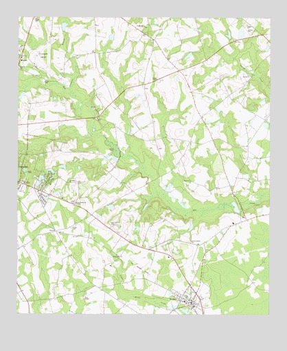
Brooklet, GA USGS Topographic Map
Click on map above to begin viewing in our Map Viewer.

This topographic map contains these locations and features:
Feature Name Type Latitude Longitude GNIS ID View Map
Beasley CemeteryCemeteryN32.4449°W81.6801°350286View Map
Bethlehem ChurchChurchN32.4305°W81.7240°311232View Map
Bible Baptist ChurchChurchN32.4556°W81.7444°2502254View Map
Brannen School (historical)SchoolN32.4418°W81.7393°334623View Map
Brians ChasePopulated PlaceN32.4535°W81.7484°350297View Map
BrookletPopulated PlaceN32.3796°W81.6632°311827View Map
Brooklet Airpark (historical)AirportN32.3832°W81.7140°351692View Map
Brooklet CemeteryCemeteryN32.3794°W81.6662°350298View Map
Brooklet Elementary SchoolSchoolN32.3866°W81.6705°350299View Map
Brooklet Police DepartmentBuildingN32.3785°W81.6619°2733774View Map
Brooklet Post OfficePost OfficeN32.3797°W81.6623°2502330View Map
Brooklet United Methodist ChurchChurchN32.3813°W81.6633°2502726View Map
Brooklet Volunteer Fire DepartmentBuildingN32.3753°W81.6575°2603874View Map
Bulloch CountyCivilN32.3968°W81.7432°350302View Map
Bulloch County Historical MuseumBuildingN32.4830°W81.7482°350305View Map
Bulloch Memorial GardensCemeteryN32.4216°W81.7221°312028View Map
City of BrookletCivilN32.3897°W81.6668°2403934View Map
Colonial HeightsPopulated PlaceN32.4285°W81.7482°350318View Map
Corinth Church (historical)ChurchN32.4057°W81.6657°334625View Map
Corinth-Leefield CemeteryCemeteryN32.4055°W81.6646°312994View Map
Elmer CemeteryCemeteryN32.4574°W81.7109°350338View Map
Elmer ChurchChurchN32.4574°W81.7098°355681View Map
English Oaks Community Mobile Home ParkPopulated PlaceN32.4145°W81.7024°2502511View Map
GrimshawPopulated PlaceN32.3991°W81.6987°326313View Map
Grove LakesPopulated PlaceN32.4293°W81.7359°350363View Map
Grove Lakes SouthPopulated PlaceN32.4224°W81.7371°350364View Map
Hodges CemeteryCemeteryN32.4971°W81.6359°315487View Map
Jones PondLakeN32.4438°W81.6998°316251View Map
Kingdom Hall of Jehovahs WitnessesChurchN32.4556°W81.7444°2502260View Map
Lee CemeteryCemeteryN32.4702°W81.6868°350384View Map
Lee PondReservoirN32.4283°W81.6746°341500View Map
Lee Pond DamDamN32.4268°W81.6748°341499View Map
Magnolia ChurchChurchN32.4313°W81.6632°317610View Map
Martin PondReservoirN32.4549°W81.6265°350391View Map
MerrywoodPopulated PlaceN32.4316°W81.7448°350396View Map
Mill Creek (historical)Populated PlaceN32.4368°W81.6801°334633View Map
Mill Creek Church (historical)ChurchN32.4316°W81.6818°334634View Map
Miller Grove CemeteryCemeteryN32.4907°W81.6434°350398View Map
Miller Grove ChurchChurchN32.4907°W81.6426°318262View Map
Moore CemeteryCemeteryN32.4160°W81.6368°350401View Map
New Sandridge ChurchChurchN32.4755°W81.6346°319543View Map
Newsome BranchStreamN32.4696°W81.7234°319582View Map
Plantation Mobile Home EstatesPopulated PlaceN32.4106°W81.7069°2502532View Map
PretoriaPopulated PlaceN32.4099°W81.7304°332758View Map
Pretoria School (historical)SchoolN32.4132°W81.7209°334636View Map
Sand Hill Ford School (historical)SchoolN32.4513°W81.6971°334637View Map
Snapp School (historical)SchoolN32.4941°W81.6859°334641View Map
Statesboro Army Air Field (historical)MilitaryN32.4833°W81.7375°1986135View Map
Statesboro Free Will ChurchChurchN32.4293°W81.7473°323542View Map
Statesboro-Bulloch County AirportAirportN32.4801°W81.7405°351911View Map
Summer Hill ChurchChurchN32.4960°W81.6862°323737View Map
Trinity Presbyterian ChurchChurchN32.4553°W81.7486°2502266View Map
WindfieldPopulated PlaceN32.4502°W81.7448°350488View Map
Youngblood PondReservoirN32.4216°W81.6447°341067View Map
Youngblood Pond DamDamN32.4202°W81.6415°341066View Map

Note: Coordinates in the location and feature list above are referenced to NAD83 datum.


Copyright (C) 2008-2025 Ryan Niemi / Sunset Dynamics ... All Rights Reserved