TopoQuest Logo
Do you find TopoQuest useful?
Help keep TopoQuest running and adding new maps/features by donating!
Bitcoin:  19c7KJd3qBynnjoSw5npx9KScwjBe4ifkT
Litecoin:  LXs6TkuXGGXo1vDsWCkWVdjQX94eUKd6ui
Home View Maps Find Maps Find Places Resources & Links


New Buffalo East, Michigan Topographic Map

USGS Map Title: New Buffalo East, MI
USGS Map MRC: 41086G6
DRG (GeoTIFF) Download: o41086g6.tif


Neighboring USGS Topographic Map Quads:


  Bridgman, MI  
41086H5
 

  New Buffalo West, MI  
41086G7
 

  New Buffalo East, MI  
41086G6
 

  Three Oaks, MI  
41086G5
 

  Michigan City East, IN  
41086F7
 

  Springville, IN  
41086F6
 

  New Carlisle, IN  
41086F5


Map MRC Location:

N42°
W87°
N42°
W86°
H8 H7 H6 H5 H4 H3 H2 H1
G8 G7 G6 G5 G4 G3 G2 G1
F8 F7 F6 F5 F4 F3 F2 F1
E8 E7 E6 E5 E4 E3 E2 E1
D8 D7 D6 D5 D4 D3 D2 D1
C8 C7 C6 C5 C4 C3 C2 C1
B8 B7 B6 B5 B4 B3 B2 B1
A8 A7 A6 A5 A4 A3 A2 A1
N41°
W87°
N41°
W86°

New Buffalo East, MI USGS 1:24K Topographic Map Preview:
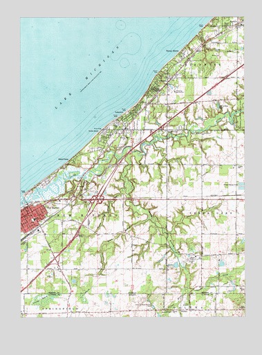
New Buffalo East, MI USGS Topographic Map
Click on map above to begin viewing in our Map Viewer.

This topographic map contains these locations and features:
Feature Name Type Latitude Longitude GNIS ID View Map
Basswood CemeteryCemeteryN41.7800°W86.6689°2374155View Map
Bible Baptist ChurchChurchN41.7900°W86.7400°2377524View Map
Blood RunStreamN41.7920°W86.6781°621609View Map
Bob-A-Ron LakeLakeN41.8379°W86.6396°621673View Map
Chikaming Country ClubLocaleN41.8439°W86.6639°1623280View Map
Chikaming Post Office (historical)Post OfficeN41.8639°W86.6444°2376493View Map
Chikaming Station (historical)LocaleN41.8639°W86.6444°2376498View Map
Chikaming Township ParkParkN41.8375°W86.6511°2377498View Map
Church of the MediatorChurchN41.8612°W86.6517°623283View Map
City of New BuffaloCivilN41.7921°W86.7421°1626798View Map
Community Baptist ChurchChurchN41.8308°W86.6958°2377386View Map
Crosby MarshSwampN41.7576°W86.7369°624114View Map
Deer CreekStreamN41.7845°W86.6681°624457View Map
Galena RiverStreamN41.7617°W86.6570°626602View Map
Galien RiverStreamN41.8012°W86.7492°626604View Map
Gordon BeachPopulated PlaceN41.8281°W86.7031°626988View Map
Grace Baptist ChurchChurchN41.7992°W86.6642°2376325View Map
HarbertPopulated PlaceN41.8720°W86.6289°627748View Map
Harbert Post OfficePost OfficeN41.8719°W86.6289°2373986View Map
Harbert Station (historical)LocaleN41.8708°W86.6283°2373987View Map
Heckman Memorial CemeteryCemeteryN41.7525°W86.6659°435970View Map
HesstonPopulated PlaceN41.7528°W86.6609°436073View Map
Hooks CornerPopulated PlaceN41.8278°W86.6684°628542View Map
Interchange 1CrossingN41.7750°W86.7311°2374183View Map
Interchange 4ACrossingN41.7989°W86.7083°2374185View Map
Interchange 4BCrossingN41.7989°W86.7056°2374187View Map
Interchange 6CrossingN41.8283°W86.6750°2374188View Map
Jehovah's WitnessesChurchN41.8131°W86.6283°2376326View Map
LakesidePopulated PlaceN41.8492°W86.6678°630020View Map
Lakeside CemeteryCemeteryN41.8458°W86.6675°2374168View Map
Lakeside Inn Historical MarkerParkN41.8428°W86.6792°2374123View Map
Lakeside Post OfficePost OfficeN41.8486°W86.6681°2377501View Map
Lakeside StationLocaleN41.8481°W86.6675°2377499View Map
Lakeside Township Police DepartmentBuildingN41.8469°W86.6694°2377500View Map
LakeviewPopulated PlaceN41.8334°W86.6928°630044View Map
Lakewood Mobile Home EstatesPopulated PlaceN41.8383°W86.6461°2376335View Map
Living Way Foursquare ChurchChurchN41.7844°W86.7414°2377523View Map
Medic 1 Emergency Medical Services New BuffaloBuildingN41.7994°W86.7218°2661945View Map
New BuffaloPopulated PlaceN41.7939°W86.7439°633317View Map
New Buffalo City HallBuildingN41.7928°W86.7469°2377537View Map
New Buffalo High SchoolSchoolN41.7958°W86.7278°2377493View Map
New Buffalo Medical CenterHospitalN41.7922°W86.7428°2377527View Map
New Buffalo Police DepartmentBuildingN41.7931°W86.7467°2377536View Map
New Buffalo Post OfficePost OfficeN41.7919°W86.7478°2377534View Map
New Buffalo Public BeachParkN41.8011°W86.7483°2377533View Map
New Buffalo Public LibraryBuildingN41.7950°W86.7425°2377535View Map
New Buffalo Railroad MuseumBuildingN41.7872°W86.7394°2377531View Map
New Buffalo StationLocaleN41.7889°W86.7389°2377532View Map
New Buffalo Township Fire Department Station 1 HeadquartersBuildingN41.8044°W86.7177°2635977View Map
New Buffalo Welcome Center Historical MarkerParkN41.7647°W86.7411°2374122View Map
Nokmes CreekStreamN41.8031°W86.6934°638665View Map
Oselka Airport (historical)AirportN41.7734°W86.6545°1618676View Map
Pokagon ReservationCivilN41.7770°W86.7141°2419058View Map
Posey ChapelChurchN41.7531°W86.6270°441476View Map
Prince of Peace Lutheran ChurchChurchN41.7992°W86.7236°2377519View Map
Saint John United Church of the CrossChurchN41.7931°W86.7461°2377525View Map
Saint Paraskevi Greek Orthodox ChurchChurchN41.7997°W86.7139°2377518View Map
Schoolcraft Middle SchoolSchoolN41.7928°W86.7336°2377494View Map
Skippers LandingLocaleN41.7970°W86.7467°1618679View Map
Sokol CampPopulated PlaceN41.8156°W86.7217°638234View Map
South Branch Galien RiverStreamN41.8189°W86.6884°638284View Map
Spring CreekStreamN41.7617°W86.6570°443976View Map
Township of New BuffaloCivilN41.7860°W86.7193°1626799View Map
Turner ShoresPopulated PlaceN41.8603°W86.6597°1615190View Map
Union PierPopulated PlaceN41.8281°W86.6925°1615354View Map
Union Pier Post OfficePost OfficeN41.8275°W86.6928°2377387View Map
Union Pier StationLocaleN41.8283°W86.6911°2377385View Map
United Methodist ChurchChurchN41.7933°W86.7436°2377520View Map
United Methodist Church of LakesideChurchN41.8481°W86.6681°2377502View Map
Wilkinson Village Heritage MuseumBuildingN41.8275°W86.6933°2377526View Map

Note: Coordinates in the location and feature list above are referenced to NAD83 datum.


Copyright (C) 2008-2024 Ryan Niemi / Sunset Dynamics ... All Rights Reserved