TopoQuest Logo
Do you find TopoQuest useful?
Help keep TopoQuest running and adding new maps/features by donating!
Bitcoin:  19c7KJd3qBynnjoSw5npx9KScwjBe4ifkT
Litecoin:  LXs6TkuXGGXo1vDsWCkWVdjQX94eUKd6ui
Home View Maps Find Maps Find Places Resources & Links


New Douglas, Illinois Topographic Map

USGS Map Title: New Douglas, IL
USGS Map MRC: 38089H6
DRG (GeoTIFF) Download: o38089h6.tif


Neighboring USGS Topographic Map Quads:


  Gillespie South, IL  
39089A7
 

  Mount Olive, IL  
39089A6
 

  Sorento North, IL  
39089A5
 

  Worden, IL  
38089H7
 

  New Douglas, IL  
38089H6
 

  Sorento South, IL  
38089H5
 

  Marine, IL  
38089G7
 

  Grantfork, IL  
38089G6
 

  Pocahontas, IL  
38089G5


Map MRC Location:

N39°
W90°
N39°
W89°
H8 H7 H6 H5 H4 H3 H2 H1
G8 G7 G6 G5 G4 G3 G2 G1
F8 F7 F6 F5 F4 F3 F2 F1
E8 E7 E6 E5 E4 E3 E2 E1
D8 D7 D6 D5 D4 D3 D2 D1
C8 C7 C6 C5 C4 C3 C2 C1
B8 B7 B6 B5 B4 B3 B2 B1
A8 A7 A6 A5 A4 A3 A2 A1
N38°
W90°
N38°
W89°

New Douglas, IL USGS 1:24K Topographic Map Preview:
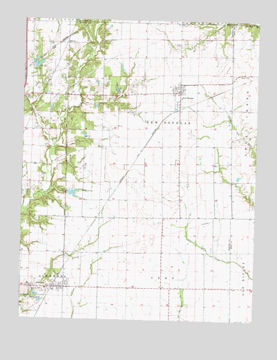
New Douglas, IL USGS Topographic Map
Click on map above to begin viewing in our Map Viewer.

This topographic map contains these locations and features:
Feature Name Type Latitude Longitude GNIS ID View Map
AlhambraPopulated PlaceN38.8884°W89.7315°403409View Map
Alhambra Elementary SchoolSchoolN38.8878°W89.7365°1812147View Map
Alhambra Fire Protection DistrictBuildingN38.8880°W89.7279°2640429View Map
Alhambra Post OfficePost OfficeN38.8881°W89.7283°2788742View Map
Alhambra Sewage Treatment PlantLocaleN38.8817°W89.7400°2468973View Map
Big Four ReservoirReservoirN38.9809°W89.7421°1691180View Map
Big Four Reservoir DamDamN38.9800°W89.7434°1691179View Map
Big Rock School (historical)SchoolN38.9028°W89.7279°1736007View Map
BinneyPopulated PlaceN38.9900°W89.7273°422463View Map
Gehrig School (historical)SchoolN38.9181°W89.6793°1736038View Map
Green CastlePopulated PlaceN38.8884°W89.7451°1812234View Map
Hammock FieldAirportN38.9134°W89.6703°427009View Map
Harris CemeteryCemeteryN38.8839°W89.7481°409839View Map
Livingston South Oil FieldOilfieldN38.9331°W89.7490°425120View Map
Mount Calvary School (historical)SchoolN38.9475°W89.6573°1736071View Map
Mueller Airport (historical)AirportN38.9345°W89.6251°427608View Map
New DouglasPopulated PlaceN38.9700°W89.6665°414394View Map
New Douglas City CemeteryCemeteryN38.9781°W89.6659°2045280View Map
New Douglas Community Volunteer Fire DepartmentBuildingN38.9713°W89.6650°2640509View Map
New Douglas Elementary SchoolSchoolN38.9678°W89.6656°1812317View Map
New Douglas Post OfficePost OfficeN38.9710°W89.6666°2788214View Map
Pisgah School (historical)SchoolN38.9473°W89.7031°1736080View Map
Pleasant Hill School (historical)SchoolN38.9756°W89.7381°1736082View Map
Rockwell School (historical)SchoolN38.8887°W89.6737°1736085View Map
Saint Ubaldus CemeteryCemeteryN38.9900°W89.6662°417828View Map
Saint Vincent CemeteryCemeteryN38.9284°W89.7184°417837View Map
Silver Creek Gliderport (historical)AirportN38.9267°W89.6617°2679070View Map
Staunton Coal Company ReservoirReservoirN38.9276°W89.7229°1691184View Map
Staunton Coal Company Reservoir DamDamN38.9284°W89.7234°1691183View Map
Township of New DouglasCivilN38.9583°W89.6732°429434View Map
Village of AlhambraCivilN38.8876°W89.7359°2397932View Map
Village of New DouglasCivilN38.9696°W89.6663°2399461View Map

Note: Coordinates in the location and feature list above are referenced to NAD83 datum.


Copyright (C) 2008-2025 Ryan Niemi / Sunset Dynamics ... All Rights Reserved