TopoQuest Logo
Do you find TopoQuest useful?
Help keep TopoQuest running and adding new maps/features by donating!
Bitcoin:  19c7KJd3qBynnjoSw5npx9KScwjBe4ifkT
Litecoin:  LXs6TkuXGGXo1vDsWCkWVdjQX94eUKd6ui
Home View Maps Find Maps Find Places Resources & Links


Worden, Illinois Topographic Map

USGS Map Title: Worden, IL
USGS Map MRC: 38089H7
DRG (GeoTIFF) Download: o38089h7.tif


Neighboring USGS Topographic Map Quads:


  Bunker Hill, IL  
39089A8
 

  Gillespie South, IL  
39089A7
 

  Mount Olive, IL  
39089A6
 

  Prairietown, IL  
38089H8
 

  Worden, IL  
38089H7
 

  New Douglas, IL  
38089H6
 

  Edwardsville, IL  
38089G8
 

  Marine, IL  
38089G7
 

  Grantfork, IL  
38089G6


Map MRC Location:

N39°
W90°
N39°
W89°
H8 H7 H6 H5 H4 H3 H2 H1
G8 G7 G6 G5 G4 G3 G2 G1
F8 F7 F6 F5 F4 F3 F2 F1
E8 E7 E6 E5 E4 E3 E2 E1
D8 D7 D6 D5 D4 D3 D2 D1
C8 C7 C6 C5 C4 C3 C2 C1
B8 B7 B6 B5 B4 B3 B2 B1
A8 A7 A6 A5 A4 A3 A2 A1
N38°
W90°
N38°
W89°

Worden, IL USGS 1:24K Topographic Map Preview:
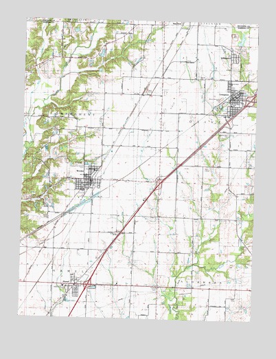
Worden, IL USGS Topographic Map
Click on map above to begin viewing in our Map Viewer.

This topographic map contains these locations and features:
Feature Name Type Latitude Longitude GNIS ID View Map
A R Graiff Elementary SchoolSchoolN38.9653°W89.7640°423457View Map
Alhambra - Hamel Ambulance ServiceBuildingN38.8954°W89.8395°2674056View Map
Assembly of God ChurchChurchN38.9370°W89.8351°423461View Map
Bend School (historical)SchoolN38.9812°W89.8234°423585View Map
Bond School (historical)SchoolN38.9812°W89.8237°1736009View Map
De CampLocaleN38.9689°W89.8118°407012View Map
First Baptist ChurchChurchN38.9684°W89.7640°423455View Map
Gehlenback Lutheran CemeteryCemeteryN38.9173°W89.8606°423464View Map
HamelPopulated PlaceN38.8889°W89.8454°409688View Map
Hamel Community CenterBuildingN38.8884°W89.8501°423466View Map
Hamel Community Fire Protection DistrictBuildingN38.8954°W89.8398°2640276View Map
Hamel Community ParkParkN38.8884°W89.8501°423465View Map
Hamel Elementary SchoolSchoolN38.8884°W89.8518°1812236View Map
Hamel Post OfficePost OfficeN38.8892°W89.8468°2788485View Map
Hamel Village Police DepartmentBuildingN38.8883°W89.8460°2758869View Map
Hazel Dell School (historical)SchoolN38.9434°W89.7543°1736049View Map
Holy Cross Lutheran ChurchChurchN38.9700°W89.7606°423454View Map
Hoxey School (historical)SchoolN38.8814°W89.8148°423591View Map
Hoxsey Family CemeteryCemeteryN38.9034°W89.7806°426960View Map
Immanuel Church (historical)ChurchN38.9562°W89.8009°423592View Map
Interchange 30CrossingN38.8889°W89.8384°1812267View Map
Interchange 33CrossingN38.9317°W89.8015°1812268View Map
Interchange 37CrossingN38.9675°W89.7534°1812269View Map
John Slifka Memorial ParkParkN38.9662°W89.7590°423458View Map
Lamb School (historical)SchoolN38.9548°W89.8415°423593View Map
LivingstonPopulated PlaceN38.9675°W89.7640°412452View Map
Livingston High School (historical)SchoolN38.9606°W89.7648°1736064View Map
Livingston Police DepartmentBuildingN38.9671°W89.7646°2759102View Map
Livingston Post OfficePost OfficeN38.9686°W89.7641°2788363View Map
McCaughey CemeteryCemeteryN38.9839°W89.8437°2045264View Map
Meadow View GardensCemeteryN38.9384°W89.8415°423460View Map
Miners Memorial ParkParkN38.9673°W89.7695°423456View Map
Moultonville School (historical)SchoolN38.9395°W89.7920°413900View Map
Mount Olive Staunton Coal Company ReservoirReservoirN38.9924°W89.7589°1691178View Map
New Hope Baptist ChurchChurchN38.9348°W89.8404°423462View Map
New Hope CemeteryCemeteryN38.9392°W89.8420°414412View Map
Olive CemeteryCemeteryN38.9312°W89.7534°415091View Map
Olive Fire District Station 1BuildingN38.9679°W89.7635°2640289View Map
Olive Fire District Station 2BuildingN38.9860°W89.7649°2640756View Map
Olive TownhallBuildingN38.9575°W89.7631°1736077View Map
Opel's Fish HatcheryLocaleN38.9267°W89.8683°2650054View Map
Opels Fish FarmLocaleN38.9456°W89.8625°2725191View Map
Sacred Heart CemeteryCemeteryN38.9534°W89.7645°426962View Map
Sacred Heart ChurchChurchN38.9742°W89.7648°423453View Map
Saint Paul ChurchChurchN38.9103°W89.8240°1736092View Map
Saint Paul Lutheran CemeteryCemeteryN38.9031°W89.8295°417696View Map
Salem Evangelical CemeteryCemeteryN38.9050°W89.7534°417857View Map
Sandbach CemeteryCemeteryN38.9523°W89.8506°423459View Map
Slifka Memorial ParkParkN38.9662°W89.7584°1736095View Map
Spangle CemeteryCemeteryN38.9767°W89.7815°423452View Map
Spangle School (historical)SchoolN38.9759°W89.7884°1736100View Map
Suhre School (historical)SchoolN38.9031°W89.7823°423598View Map
Township of HamelCivilN38.8752°W89.8714°429099View Map
Township of OliveCivilN38.9581°W89.7602°429487View Map
Township of OmphghentCivilN38.9588°W89.8700°429491View Map
Trinity Lutheran ChurchChurchN38.9292°W89.8409°423467View Map
Trinity Lutheran SchoolSchoolN38.9295°W89.8409°423463View Map
Vesper LakeReservoirN38.9859°W89.8336°1691176View Map
Vesper Lake DamDamN38.9850°W89.8351°1691175View Map
Village of HamelCivilN38.8892°W89.8426°2398229View Map
Village of LivingstonCivilN38.9681°W89.7643°2398457View Map
Village of WilliamsonCivilN38.9872°W89.7644°2399696View Map
Village of WordenCivilN38.9314°W89.8404°2399741View Map
West Fork Cahokia CreekStreamN38.9567°W89.8718°420828View Map
West School (historical)SchoolN38.8798°W89.7631°1736110View Map
WilliamsonPopulated PlaceN38.9856°W89.7640°421214View Map
Williamson DamDamN38.9900°W89.7584°1691177View Map
WordenPopulated PlaceN38.9314°W89.8390°421503View Map
Worden City HallBuildingN38.9317°W89.8398°1736115View Map
Worden Fire DepartmentBuildingN38.9319°W89.8407°2640379View Map
Worden High SchoolSchoolN38.9328°W89.8384°1736116View Map
Worden Police DepartmentBuildingN38.9318°W89.8399°2758883View Map
Worden Post OfficePost OfficeN38.9318°W89.8391°1736117View Map

Note: Coordinates in the location and feature list above are referenced to NAD83 datum.


Copyright (C) 2008-2024 Ryan Niemi / Sunset Dynamics ... All Rights Reserved