TopoQuest Logo
Do you find TopoQuest useful?
Help keep TopoQuest running and adding new maps/features by donating!
Bitcoin:  19c7KJd3qBynnjoSw5npx9KScwjBe4ifkT
Litecoin:  LXs6TkuXGGXo1vDsWCkWVdjQX94eUKd6ui
Home View Maps Find Maps Find Places Resources & Links


New Edinburg, Arkansas Topographic Map

USGS Map Title: New Edinburg, AR
USGS Map MRC: 33092G2
DRG (GeoTIFF) Download: o33092g2.tif


Neighboring USGS Topographic Map Quads:


  Fordyce NE, AR  
33092H3
 

  Rison, AR  
33092H2
 

  Calmer, AR  
33092H1
 

  Kingsland, AR  
33092G3
 

  New Edinburg, AR  
33092G2
 

  Herbine, AR  
33092G1
 

  Tinsman, AR  
33092F3
 

  McKinney, AR  
33092F2
 

  Warren NE, AR  
33092F1


Map MRC Location:

N34°
W93°
N34°
W92°
H8 H7 H6 H5 H4 H3 H2 H1
G8 G7 G6 G5 G4 G3 G2 G1
F8 F7 F6 F5 F4 F3 F2 F1
E8 E7 E6 E5 E4 E3 E2 E1
D8 D7 D6 D5 D4 D3 D2 D1
C8 C7 C6 C5 C4 C3 C2 C1
B8 B7 B6 B5 B4 B3 B2 B1
A8 A7 A6 A5 A4 A3 A2 A1
N33°
W93°
N33°
W92°

New Edinburg, AR USGS 1:24K Topographic Map Preview:
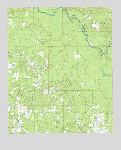
New Edinburg, AR USGS Topographic Map
Click on map above to begin viewing in our Map Viewer.

This topographic map contains these locations and features:
Feature Name Type Latitude Longitude GNIS ID View Map
Bridges BluffCliffN33.8734°W92.1815°46947View Map
Chapel Hill ChurchChurchN33.7504°W92.1607°47696View Map
Cottonmouth CreekStreamN33.8668°W92.1965°48070View Map
Crane LakeLakeN33.8068°W92.1332°75686View Map
Frazier CreekStreamN33.8504°W92.1601°49226View Map
Hall CreekStreamN33.8270°W92.1382°49785View Map
HebronPopulated PlaceN33.8145°W92.2226°60989View Map
Hebron ChurchChurchN33.8151°W92.2218°49985View Map
Larson Lake DamDamN33.7784°W92.2485°80301View Map
Macedonia ChurchChurchN33.8690°W92.1254°51568View Map
Marks CemeteryCemeteryN33.7854°W92.2435°51677View Map
Mason (historical)Populated PlaceN33.7787°W92.1993°60995View Map
Mill CreekStreamN33.8712°W92.2138°52011View Map
Moseley CemeteryCemeteryN33.7609°W92.1929°52233View Map
Mount ElbaPopulated PlaceN33.8509°W92.1585°58220View Map
Mount Elba ChurchChurchN33.8170°W92.2043°52286View Map
New EdinburgPopulated PlaceN33.7573°W92.2385°77811View Map
New Edinburg Census Designated PlaceCensusN33.7565°W92.2402°2582920View Map
New Edinburg Post OfficePost OfficeN33.7576°W92.2382°2781937View Map
New Edinburg Volunteer Fire StationBuildingN33.7590°W92.2406°2116847View Map
Piney Grove ChurchChurchN33.7909°W92.1796°53489View Map
Saint Francis ChurchChurchN33.7959°W92.2013°54325View Map
Sneed (historical)Populated PlaceN33.8287°W92.2104°61004View Map
Thompson CreekStreamN33.7776°W92.1451°55540View Map
Township of RedlandCivilN33.7757°W92.2268°63742View Map
Varnell CreekStreamN33.8737°W92.1896°55889View Map

Note: Coordinates in the location and feature list above are referenced to NAD83 datum.


Copyright (C) 2008-2025 Ryan Niemi / Sunset Dynamics ... All Rights Reserved