TopoQuest Logo
Do you find TopoQuest useful?
Help keep TopoQuest running and adding new maps/features by donating!
Bitcoin:  19c7KJd3qBynnjoSw5npx9KScwjBe4ifkT
Litecoin:  LXs6TkuXGGXo1vDsWCkWVdjQX94eUKd6ui
Home View Maps Find Maps Find Places Resources & Links


New Franklin, Missouri Topographic Map

USGS Map Title: New Franklin, MO
USGS Map MRC: 39092A6
DRG (GeoTIFF) Download: o39092a6.tif


Neighboring USGS Topographic Map Quads:


  Glasgow, MO  
39092B7
 

  Fayette, MO  
39092B6
 

  Burton, MO  
39092B5
 

  Franklin, MO  
39092A7
 

  New Franklin, MO  
39092A6
 

  Hilldale, MO  
39092A5
 

  Billingsville, MO  
38092H7
 

  Boonville, MO  
38092H6
 

  Rocheport, MO  
38092H5


Map MRC Location:

N40°
W93°
N40°
W92°
H8 H7 H6 H5 H4 H3 H2 H1
G8 G7 G6 G5 G4 G3 G2 G1
F8 F7 F6 F5 F4 F3 F2 F1
E8 E7 E6 E5 E4 E3 E2 E1
D8 D7 D6 D5 D4 D3 D2 D1
C8 C7 C6 C5 C4 C3 C2 C1
B8 B7 B6 B5 B4 B3 B2 B1
A8 A7 A6 A5 A4 A3 A2 A1
N39°
W93°
N39°
W92°

New Franklin, MO USGS 1:24K Topographic Map Preview:
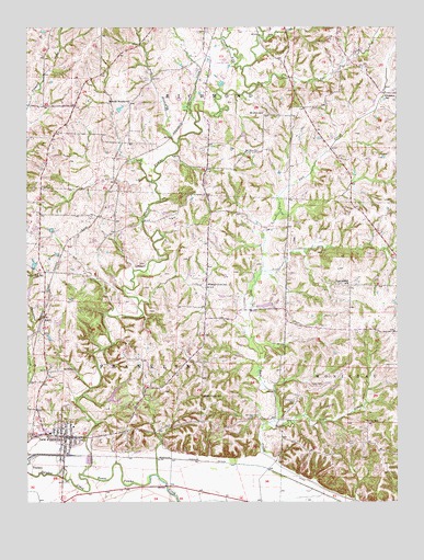
New Franklin, MO USGS Topographic Map
Click on map above to begin viewing in our Map Viewer.

This topographic map contains these locations and features:
Feature Name Type Latitude Longitude GNIS ID View Map
Adams ForkStreamN39.1142°W92.6769°729270View Map
BoonslickAreaN39.0834°W92.6669°760186View Map
Buckharts (historical)LocaleN39.0750°W92.7266°743536View Map
Cedar Grove School (historical)SchoolN39.0278°W92.6907°715600View Map
Central Hill School (historical)SchoolN39.0570°W92.6413°715678View Map
Cherry Grove School (historical)SchoolN39.0570°W92.6891°715765View Map
City of New FranklinCivilN39.0175°W92.7406°2395194View Map
Davis Lake DamDamN39.0717°W92.7452°762243View Map
Doe CreekStreamN39.1098°W92.6724°716945View Map
Drake CemeteryCemeteryN39.0309°W92.6505°717044View Map
Dry CreekStreamN39.1220°W92.6699°717096View Map
Dudgeon School (historical)SchoolN39.1067°W92.6291°729303View Map
Eaton BranchStreamN39.0209°W92.6682°717370View Map
EstillPopulated PlaceN39.0484°W92.7444°740838View Map
Fayette Flying Field (historical)AirportN39.1167°W92.6835°758678View Map
Gray School (historical)SchoolN39.0014°W92.6885°759478View Map
Howell Lake DamDamN39.1034°W92.7185°762244View Map
Mount Pleasant CemeteryCemeteryN39.0346°W92.7411°722852View Map
Mount Zion ChurchChurchN39.0920°W92.6763°722960View Map
Mount Zion School (historical)SchoolN39.1023°W92.6705°722980View Map
New FranklinPopulated PlaceN39.0173°W92.7374°723198View Map
New Franklin Elementary SchoolSchoolN39.0180°W92.7427°743473View Map
New Franklin Fire Department Howard County Fire Protection District Station 2BuildingN39.0236°W92.7471°2620955View Map
New Franklin High SchoolSchoolN39.0184°W92.7434°2571112View Map
New Franklin Police DepartmentBuildingN39.0174°W92.7361°2752125View Map
New Franklin Post OfficePost OfficeN39.0174°W92.7362°2782934View Map
Robb BranchStreamN39.0945°W92.6991°725387View Map
Robinson CemeteryCemeteryN39.0264°W92.6599°725415View Map
Rosalee (historical)LocaleN39.0084°W92.6682°759481View Map
Spanish Needles School (historical)SchoolN39.1045°W92.7155°729397View Map
Sulphur CreekStreamN39.0070°W92.7310°727272View Map
Talbot (historical)LocaleN39.0945°W92.7030°743437View Map
Township of FranklinCivilN39.0301°W92.7473°766777View Map
Turner School (historical)SchoolN39.0211°W92.6360°727906View Map
White Hall School (historical)SchoolN39.0603°W92.7455°728733View Map

Note: Coordinates in the location and feature list above are referenced to NAD83 datum.


Copyright (C) 2008-2024 Ryan Niemi / Sunset Dynamics ... All Rights Reserved