TopoQuest Logo
Do you find TopoQuest useful?
Help keep TopoQuest running and adding new maps/features by donating!
Bitcoin:  19c7KJd3qBynnjoSw5npx9KScwjBe4ifkT
Litecoin:  LXs6TkuXGGXo1vDsWCkWVdjQX94eUKd6ui
Home View Maps Find Maps Find Places Resources & Links


Billingsville, Missouri Topographic Map

USGS Map Title: Billingsville, MO
USGS Map MRC: 38092H7
DRG (GeoTIFF) Download: o38092h7.tif


Neighboring USGS Topographic Map Quads:


  Arrow Rock, MO  
39092A8
 

  Franklin, MO  
39092A7
 

  New Franklin, MO  
39092A6
 

  Pilot Grove North, MO  
38092H8
 

  Billingsville, MO  
38092H7
 

  Boonville, MO  
38092H6
 

  Pilot Grove South, MO  
38092G8
 

  Bunceton, MO  
38092G7
 

  Lone Elm, MO  
38092G6


Map MRC Location:

N39°
W93°
N39°
W92°
H8 H7 H6 H5 H4 H3 H2 H1
G8 G7 G6 G5 G4 G3 G2 G1
F8 F7 F6 F5 F4 F3 F2 F1
E8 E7 E6 E5 E4 E3 E2 E1
D8 D7 D6 D5 D4 D3 D2 D1
C8 C7 C6 C5 C4 C3 C2 C1
B8 B7 B6 B5 B4 B3 B2 B1
A8 A7 A6 A5 A4 A3 A2 A1
N38°
W93°
N38°
W92°

Billingsville, MO USGS 1:24K Topographic Map Preview:
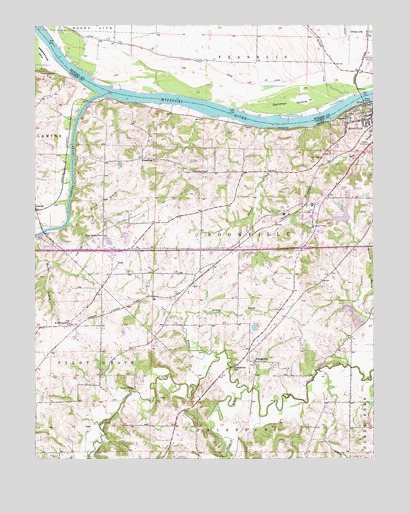
Billingsville, MO USGS Topographic Map
Click on map above to begin viewing in our Map Viewer.

This topographic map contains these locations and features:
Feature Name Type Latitude Longitude GNIS ID View Map
Bartlett CreekStreamN38.9795°W92.7588°729278View Map
BillingsvillePopulated PlaceN38.9031°W92.7944°740678View Map
Billingsville School (historical)SchoolN38.9014°W92.8021°714240View Map
Boonslick Technical Education CenterSchoolN38.9403°W92.7689°2571147View Map
Boonville BendsBendN38.9744°W92.8033°2109748View Map
Boonville High SchoolSchoolN38.9408°W92.7702°759457View Map
Boonville Municipal Airport (historical)AirportN38.9917°W92.7502°758596View Map
Clear Spring School (historical)SchoolN38.9395°W92.8507°715953View Map
Cooper County Fire Protection District Station 2BuildingN38.9363°W92.8401°2620546View Map
Cooper County Fire Protection District Station 4BuildingN38.9055°W92.7964°2620613View Map
De Bourgmont AccessLocaleN38.9417°W92.8708°2109749View Map
East Oakland School (historical)SchoolN38.8761°W92.8652°743864View Map
Evangelical ChurchChurchN38.9614°W92.8299°717671View Map
Friedrich LakeReservoirN38.9128°W92.7942°764387View Map
Friedrich Lake DamDamN38.9117°W92.7952°764386View Map
Gardner IslandAreaN38.9778°W92.7796°718340View Map
Grassy BranchStreamN38.9428°W92.8632°718717View Map
Grassy LakeLakeN38.9984°W92.7593°718732View Map
Hannah Cole Primary SchoolSchoolN38.9379°W92.7675°2571146View Map
Hickory BranchStreamN38.9153°W92.8196°719432View Map
Hickory Grove School (historical)SchoolN38.9345°W92.8046°743861View Map
Holtzclaw Lake DamDamN38.9384°W92.8485°761426View Map
KDBX-FM (Boonville)TowerN38.9456°W92.7707°759108View Map
Kemper Golf CourseLocaleN38.9661°W92.7535°755247View Map
Kingsbury (historical)LocaleN38.9867°W92.7560°743483View Map
KWRT-AM (Boonville)TowerN38.9456°W92.7707°759239View Map
LaminePopulated PlaceN38.9467°W92.8746°720776View Map
Lamine RiverStreamN38.9797°W92.8513°729761View Map
Lamine River BendBendN38.9830°W92.8536°2109747View Map
LickLocaleN38.9259°W92.8169°739999View Map
Lick BranchStreamN38.9056°W92.8082°721012View Map
Martin BranchStreamN38.9389°W92.8738°721916View Map
McCoy Number 1 ReservoirReservoirN38.9505°W92.7525°760434View Map
Moon CreekStreamN38.9853°W92.8616°722557View Map
Old Channel Salt CreekStreamN38.9947°W92.8669°723734View Map
Oswald Lake DamDamN38.9434°W92.7602°761427View Map
Pleasant Hill CemeteryCemeteryN38.8956°W92.8385°724518View Map
Prairie View School (historical)SchoolN38.9067°W92.8505°743863View Map
River of Life Assembly of God ChurchChurchN38.9533°W92.7641°2542483View Map
Rupe BranchStreamN38.9784°W92.7510°725662View Map
Saint Martin School (historical)SchoolN38.9142°W92.8627°725823View Map
Schrader Lake DamDamN38.9400°W92.8435°765393View Map
Southwest Dam Number 1DamN38.9500°W92.7502°760433View Map
Stephens BranchStreamN38.8947°W92.7971°727067View Map
Stony Point School (historical)SchoolN38.9117°W92.7580°743862View Map
Thomas BranchStreamN38.9706°W92.7919°727574View Map
Township of BoonvilleCivilN38.9435°W92.7575°766527View Map
Trout DamDamN38.9517°W92.7685°761433View Map
Trout LakeReservoirN38.9515°W92.7686°761434View Map
Westwood School (historical)SchoolN38.9581°W92.8113°728661View Map

Note: Coordinates in the location and feature list above are referenced to NAD83 datum.


Copyright (C) 2008-2025 Ryan Niemi / Sunset Dynamics ... All Rights Reserved