TopoQuest Logo
Do you find TopoQuest useful?
Help keep TopoQuest running and adding new maps/features by donating!
Bitcoin:  19c7KJd3qBynnjoSw5npx9KScwjBe4ifkT
Litecoin:  LXs6TkuXGGXo1vDsWCkWVdjQX94eUKd6ui
Home View Maps Find Maps Find Places Resources & Links


Boonville, Missouri Topographic Map

USGS Map Title: Boonville, MO
USGS Map MRC: 38092H6
DRG (GeoTIFF) Download: o38092h6.tif


Neighboring USGS Topographic Map Quads:


  Franklin, MO  
39092A7
 

  New Franklin, MO  
39092A6
 

  Hilldale, MO  
39092A5
 

  Billingsville, MO  
38092H7
 

  Boonville, MO  
38092H6
 

  Rocheport, MO  
38092H5
 

  Bunceton, MO  
38092G7
 

  Lone Elm, MO  
38092G6
 

  Prairie Home, MO  
38092G5


Map MRC Location:

N39°
W93°
N39°
W92°
H8 H7 H6 H5 H4 H3 H2 H1
G8 G7 G6 G5 G4 G3 G2 G1
F8 F7 F6 F5 F4 F3 F2 F1
E8 E7 E6 E5 E4 E3 E2 E1
D8 D7 D6 D5 D4 D3 D2 D1
C8 C7 C6 C5 C4 C3 C2 C1
B8 B7 B6 B5 B4 B3 B2 B1
A8 A7 A6 A5 A4 A3 A2 A1
N38°
W93°
N38°
W92°

Boonville, MO USGS 1:24K Topographic Map Preview:
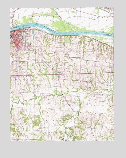
Boonville, MO USGS Topographic Map
Click on map above to begin viewing in our Map Viewer.

This topographic map contains these locations and features:
Feature Name Type Latitude Longitude GNIS ID View Map
Anderson BranchStreamN38.9131°W92.7396°713277View Map
Bluffton SchoolSchoolN38.9561°W92.6799°714449View Map
Bonne Femme CreekStreamN38.9781°W92.6657°729281View Map
BoonvillePopulated PlaceN38.9736°W92.7432°714540View Map
Boonville Correctional CenterBuildingN38.9775°W92.7296°2490657View Map
Boonville Fire DepartmentBuildingN38.9661°W92.7403°2620321View Map
Boonville Fire Department SubstationBuildingN38.9763°W92.7428°2621143View Map
Boonville Police DepartmentBuildingN38.9766°W92.7454°2752546View Map
Boonville Post OfficePost OfficeN38.9755°W92.7425°2779504View Map
Central Elementary School (historical)SchoolN38.9692°W92.7407°2571143View Map
City of BoonvilleCivilN38.9588°W92.7470°2394222View Map
Clark ForkStreamN38.9225°W92.6685°729294View Map
Clarks ForkPopulated PlaceN38.8870°W92.6527°740746View Map
Concord School (historical)SchoolN38.8914°W92.7452°716183View Map
Cooper County Fire Protection District Station 1BuildingN38.9336°W92.6908°2620954View Map
Cooper County HomeBuildingN38.9667°W92.7321°742752View Map
Cooper County Memorial HospitalHospitalN38.9442°W92.7407°2655062View Map
Cooper County Sheriff's OfficeBuildingN38.9775°W92.7435°2752355View Map
Crab Orchard School (historical)SchoolN38.9000°W92.6960°743852View Map
David Barton Elementary SchoolSchoolN38.9727°W92.7369°2571144View Map
Dodson School (historical)SchoolN38.9915°W92.6290°743441View Map
Fairview School (historical)SchoolN38.8909°W92.6541°743853View Map
Franklin BendBendN38.9839°W92.7164°2109773View Map
Franklin IslandIslandN38.9856°W92.6955°718165View Map
Franklin Island ReachBendN38.9764°W92.6742°2118095View Map
Hail Ridge SchoolSchoolN38.9395°W92.6932°718979View Map
Jesse Viertel Memorial AirportAirportN38.9432°W92.6846°758595View Map
Laura Speed Elliott Middle SchoolSchoolN38.9721°W92.7423°2571145View Map
Lilly BranchStreamN38.9820°W92.7205°721056View Map
MernaPopulated PlaceN38.9711°W92.6496°741062View Map
Mount Hermon ChurchChurchN38.8820°W92.7338°722761View Map
Mount Sinai School (historical)SchoolN38.9475°W92.7477°743850View Map
Number 226 ReservoirReservoirN38.9618°W92.7135°761334View Map
Panther BranchStreamN38.9147°W92.7119°723980View Map
Pleasant Valley School (historical)SchoolN38.9092°W92.6499°743851View Map
Ream BranchStreamN38.9811°W92.7360°725145View Map
Rolfling LakeReservoirN38.9755°W92.7215°760780View Map
Rolfling Lake Section 36 DamDamN38.9784°W92.7219°760779View Map
Rolfling Lake Section 6 DamDamN38.9634°W92.7135°761333View Map
Saint Joseph ConventChurchN38.9798°W92.7310°725802View Map
Saints Peter and Paul Catholic SchoolSchoolN38.9750°W92.7396°759454View Map
Schnuck Lake DamDamN38.9434°W92.6985°762248View Map
Smith Lake DamDamN38.9550°W92.7102°762249View Map
State Boys School (historical)SchoolN38.9774°W92.7303°742753View Map
Stoelting DamDamN38.9534°W92.7385°761454View Map
Stoelting LakeReservoirN38.9538°W92.7395°761455View Map
Sumner School (historical)SchoolN38.9800°W92.7347°2572914View Map
Sumner School (historical)SchoolN38.9705°W92.7443°2572915View Map
Village of Windsor PlaceCivilN38.9343°W92.7031°2399714View Map
Walnut Grove CemeteryCemeteryN38.9717°W92.7324°728304View Map
West Branch Clark ForkStreamN38.8870°W92.6816°728532View Map
Windmill Campground DamDamN38.9284°W92.7402°760432View Map
Windsor PlacePopulated PlaceN38.9328°W92.6933°2104300View Map
Windsor Place Number 1 DamDamN38.8850°W92.7152°764149View Map
Windsor Place Number 2 DamDamN38.8917°W92.7219°764148View Map
Woodland SchoolSchoolN38.9439°W92.6302°729103View Map

Note: Coordinates in the location and feature list above are referenced to NAD83 datum.


Copyright (C) 2008-2024 Ryan Niemi / Sunset Dynamics ... All Rights Reserved