TopoQuest Logo
Do you find TopoQuest useful?
Help keep TopoQuest running and adding new maps/features by donating!
Bitcoin:  19c7KJd3qBynnjoSw5npx9KScwjBe4ifkT
Litecoin:  LXs6TkuXGGXo1vDsWCkWVdjQX94eUKd6ui
Home View Maps Find Maps Find Places Resources & Links


Franklin, Missouri Topographic Map

USGS Map Title: Franklin, MO
USGS Map MRC: 39092A7
DRG (GeoTIFF) Download: o39092a7.tif


Neighboring USGS Topographic Map Quads:


  Saline City, MO  
39092B8
 

  Glasgow, MO  
39092B7
 

  Fayette, MO  
39092B6
 

  Arrow Rock, MO  
39092A8
 

  Franklin, MO  
39092A7
 

  New Franklin, MO  
39092A6
 

  Pilot Grove North, MO  
38092H8
 

  Billingsville, MO  
38092H7
 

  Boonville, MO  
38092H6


Map MRC Location:

N40°
W93°
N40°
W92°
H8 H7 H6 H5 H4 H3 H2 H1
G8 G7 G6 G5 G4 G3 G2 G1
F8 F7 F6 F5 F4 F3 F2 F1
E8 E7 E6 E5 E4 E3 E2 E1
D8 D7 D6 D5 D4 D3 D2 D1
C8 C7 C6 C5 C4 C3 C2 C1
B8 B7 B6 B5 B4 B3 B2 B1
A8 A7 A6 A5 A4 A3 A2 A1
N39°
W93°
N39°
W92°

Franklin, MO USGS 1:24K Topographic Map Preview:
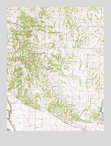
Franklin, MO USGS Topographic Map
Click on map above to begin viewing in our Map Viewer.

This topographic map contains these locations and features:
Feature Name Type Latitude Longitude GNIS ID View Map
Ashland School (historical)SchoolN39.1048°W92.7794°743532View Map
Blankenbaker School (historical)SchoolN39.0023°W92.8631°743531View Map
BoonesboroPopulated PlaceN39.0770°W92.8416°729283View Map
Boonsboro School (historical)SchoolN39.0744°W92.8437°743438View Map
Burton School (historical)SchoolN39.1029°W92.8533°743530View Map
Carson BranchStreamN39.1003°W92.8113°715437View Map
Church of God (historical)ChurchN39.0834°W92.8460°743439View Map
City of FranklinCivilN39.0112°W92.7550°2394811View Map
Clarks ChapelChurchN39.0103°W92.7849°715891View Map
Clarks Chapel School (historical)SchoolN39.0117°W92.7867°743529View Map
Cottonwood CreekStreamN39.0075°W92.7574°716364View Map
East Fork Sulphur CreekStreamN39.0698°W92.7799°717304View Map
Fairview School (historical)SchoolN39.0409°W92.8163°743528View Map
Farmers Hill School (historical)SchoolN39.0940°W92.8078°766175View Map
FranklinPopulated PlaceN39.0117°W92.7532°718163View Map
Franklin Post OfficePost OfficeN39.0119°W92.7523°2782789View Map
Goose CreekStreamN39.0556°W92.7849°718584View Map
Horticulture LakeReservoirN39.0159°W92.7572°761438View Map
Lippold Lake DamDamN39.0500°W92.7502°762245View Map
M K T LakeReservoirN39.0213°W92.7548°758309View Map
Missouri Department of Conservation Forestry Central Regional Field Fire Office New FranklinBuildingN39.0171°W92.7554°2621311View Map
New Horticulture Farm DamDamN39.0150°W92.7569°761437View Map
Okaydy Reservoir DamDamN39.0189°W92.7541°760191View Map
Sampson BranchStreamN39.0347°W92.8749°725992View Map
Sand BranchStreamN39.0409°W92.8346°725998View Map
Tanyard CreekStreamN39.0978°W92.7569°727455View Map
Tippett BranchStreamN39.1039°W92.8132°727678View Map
Township of BoonslickCivilN39.0721°W92.8627°766774View Map
West Fork Sulphur CreekStreamN39.0786°W92.7899°729410View Map

Note: Coordinates in the location and feature list above are referenced to NAD83 datum.


Copyright (C) 2008-2024 Ryan Niemi / Sunset Dynamics ... All Rights Reserved