TopoQuest Logo
Do you find TopoQuest useful?
Help keep TopoQuest running and adding new maps/features by donating!
Bitcoin:  19c7KJd3qBynnjoSw5npx9KScwjBe4ifkT
Litecoin:  LXs6TkuXGGXo1vDsWCkWVdjQX94eUKd6ui
Home View Maps Find Maps Find Places Resources & Links


New Freeport, Pennsylvania Topographic Map

USGS Map Title: New Freeport, PA
USGS Map MRC: 39080G4
DRG (GeoTIFF) Download: o39080g4.tif


Neighboring USGS Topographic Map Quads:


  Majorsville, WV  
39080H5
 

  Wind Ridge, PA  
39080H4
 

  Rogersville, PA  
39080H3
 

  Cameron, WV  
39080G5
 

  New Freeport, PA  
39080G4
 

  Holbrook, PA  
39080G3
 

  Littleton, WV  
39080F5
 

  Hundred, WV  
39080F4
 

  Wadestown, WV  
39080F3


Map MRC Location:

N40°
W81°
N40°
W80°
H8 H7 H6 H5 H4 H3 H2 H1
G8 G7 G6 G5 G4 G3 G2 G1
F8 F7 F6 F5 F4 F3 F2 F1
E8 E7 E6 E5 E4 E3 E2 E1
D8 D7 D6 D5 D4 D3 D2 D1
C8 C7 C6 C5 C4 C3 C2 C1
B8 B7 B6 B5 B4 B3 B2 B1
A8 A7 A6 A5 A4 A3 A2 A1
N39°
W81°
N39°
W80°

New Freeport, PA USGS 1:24K Topographic Map Preview:
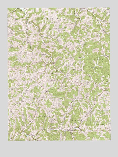
New Freeport, PA USGS Topographic Map
Click on map above to begin viewing in our Map Viewer.

This topographic map contains these locations and features:
Feature Name Type Latitude Longitude GNIS ID View Map
AleppoPopulated PlaceN39.8240°W80.4462°1202959View Map
Aleppo Post OfficePost OfficeN39.8220°W80.4435°2772568View Map
Barneys RunStreamN39.8740°W80.4820°1168748View Map
Bissett RunStreamN39.7540°W80.4690°1169674View Map
Blacks CreekStreamN39.8467°W80.4573°1169771View Map
BristoriaPopulated PlaceN39.8737°W80.4087°1192188View Map
Centennial ChurchChurchN39.8037°W80.4098°1171418View Map
Chambers RunStreamN39.8381°W80.4817°1171541View Map
Cook RunStreamN39.7651°W80.4756°1172383View Map
Deep ValleyPopulated PlaceN39.7548°W80.4695°1173075View Map
DelphenePopulated PlaceN39.8301°W80.3801°1203400View Map
Dunkard CemeteryCemeteryN39.8309°W80.4578°1173609View Map
Evans CemeteryCemeteryN39.8151°W80.4334°1174341View Map
Falling Timber RunStreamN39.8545°W80.3842°1174596View Map
Hamilton RunStreamN39.7587°W80.4251°1176425View Map
Herod RunStreamN39.7609°W80.4359°1176881View Map
Hewitt RunStreamN39.8526°W80.4776°1176928View Map
Hewitt RunStreamN39.8606°W80.4748°1540190View Map
HigbeePopulated PlaceN39.8409°W80.4059°1203800View Map
Highbee Post Office (historical)Post OfficeN39.8406°W80.4056°1802648View Map
Job CreekStreamN39.8637°W80.3862°1178090View Map
Laurel RunStreamN39.7601°W80.4562°1200094View Map
Laurel Run ChurchChurchN39.7601°W80.4562°1179023View Map
Long RunStreamN39.8681°W80.4145°1179881View Map
Long Run ChurchChurchN39.8648°W80.4109°1179900View Map
McCrackenPopulated PlaceN39.8537°W80.4759°1180667View Map
McDay CemeteryCemeteryN39.8167°W80.4156°1180687View Map
Miller CemeteryCemeteryN39.7912°W80.4825°1181208View Map
Monkey HollowValleyN39.7615°W80.4478°1181420View Map
MorfordPopulated PlaceN39.7970°W80.4781°1204209View Map
Mount Carmel RidgeRidgeN39.7865°W80.4854°1181676View Map
Mudlick ForkStreamN39.8601°W80.4745°1182062View Map
Nettle HillPopulated PlaceN39.7967°W80.3829°1204272View Map
New FreeportPopulated PlaceN39.7598°W80.4256°1182320View Map
New Freeport Census Designated PlaceCensusN39.7594°W80.4279°2630030View Map
New Freeport Post OfficePost OfficeN39.7594°W80.4264°2779568View Map
New Freeport Volunteer Fire Department Company 71BuildingN39.7596°W80.4260°2644976View Map
Pleasant Hill ChurchChurchN39.7606°W80.3854°1184035View Map
RiggsPopulated PlaceN39.8604°W80.4529°1204508View Map
Schess CemeteryCemeteryN39.8673°W80.4642°1187083View Map
Smith BridgeLocaleN39.8606°W80.4756°1187855View Map
Springhill-Freeport SchoolSchoolN39.7612°W80.4479°1188301View Map
Staggers CemeteryCemeteryN39.8636°W80.3892°1188380View Map
State Game Lands Number 179ParkN39.8251°W80.3923°1188472View Map
Strawn HollowValleyN39.8692°W80.4786°1193490View Map
Sugar Grove ChurchChurchN39.8537°W80.4765°1188934View Map
Township of AleppoCivilN39.8232°W80.4605°1215250View Map
Township of SpringhillCivilN39.7585°W80.4759°1215260View Map
Wagonroad RunStreamN39.7579°W80.4809°1190482View Map
Webster RunStreamN39.8634°W80.3856°1193618View Map
Whitethorn RunStreamN39.8729°W80.4078°1193656View Map
Windy GapPopulated PlaceN39.7962°W80.4537°1204970View Map

Note: Coordinates in the location and feature list above are referenced to NAD83 datum.


Copyright (C) 2008-2024 Ryan Niemi / Sunset Dynamics ... All Rights Reserved