TopoQuest Logo
Do you find TopoQuest useful?
Help keep TopoQuest running and adding new maps/features by donating!
Bitcoin:  19c7KJd3qBynnjoSw5npx9KScwjBe4ifkT
Litecoin:  LXs6TkuXGGXo1vDsWCkWVdjQX94eUKd6ui
Home View Maps Find Maps Find Places Resources & Links


New Home, Missouri Topographic Map

USGS Map Title: New Home, MO
USGS Map MRC: 38094B4
DRG (GeoTIFF) Download: o38094b4.tif


Neighboring USGS Topographic Map Quads:


  Amoret, MO  
38094C5
 

  Virginia, MO  
38094C4
 

  Butler, MO  
38094C3
 

  Worland, MO  
38094B5
 

  New Home, MO  
38094B4
 

  Butler South, MO  
38094B3
 

  Hume, MO  
38094A5
 

  Sprague, MO  
38094A4
 

  Rich Hill, MO  
38094A3


Map MRC Location:

N39°
W95°
N39°
W94°
H8 H7 H6 H5 H4 H3 H2 H1
G8 G7 G6 G5 G4 G3 G2 G1
F8 F7 F6 F5 F4 F3 F2 F1
E8 E7 E6 E5 E4 E3 E2 E1
D8 D7 D6 D5 D4 D3 D2 D1
C8 C7 C6 C5 C4 C3 C2 C1
B8 B7 B6 B5 B4 B3 B2 B1
A8 A7 A6 A5 A4 A3 A2 A1
N38°
W95°
N38°
W94°

New Home, MO USGS 1:24K Topographic Map Preview:
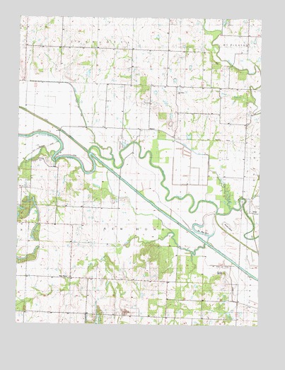
New Home, MO USGS Topographic Map
Click on map above to begin viewing in our Map Viewer.

This topographic map contains these locations and features:
Feature Name Type Latitude Longitude GNIS ID View Map
AtholPopulated PlaceN38.1725°W94.3788°740641View Map
Belmont School (historical)SchoolN38.2376°W94.4599°748333View Map
Big Shoe BendBendN38.1638°W94.4041°714210View Map
Black Diamond MineMineN38.1667°W94.4919°714289View Map
Brushy MoundSummitN38.1461°W94.3925°714921View Map
Brushy Mound Lake (historical)ReservoirN38.1420°W94.3861°748340View Map
CornlandPopulated PlaceN38.1778°W94.3838°739486View Map
Cornland School (historical)SchoolN38.1853°W94.3833°716329View Map
Double S BendBendN38.1656°W94.3883°717000View Map
Ehart BranchStreamN38.2156°W94.3783°717420View Map
Enterprise School (historical)SchoolN38.2365°W94.4232°748357View Map
Grandview School (historical)SchoolN38.2386°W94.4972°729896View Map
Hillside School (historical)SchoolN38.1536°W94.4166°748382View Map
Lateral Ditch Number 2CanalN38.2161°W94.4708°755258View Map
Lateral Ditch Number 3CanalN38.1992°W94.4180°755259View Map
Lateral Ditch Number ThreeCanalN38.1959°W94.4211°736248View Map
Long Lake (historical)LakeN38.1828°W94.4369°748402View Map
Lost Corner School (historical)SchoolN38.2220°W94.3916°748403View Map
Morris CemeteryCemeteryN38.2317°W94.4002°722640View Map
New HomePopulated PlaceN38.1436°W94.4725°740006View Map
New Home CreekStreamN38.1581°W94.4025°723225View Map
New Home School (historical)SchoolN38.1434°W94.4662°746032View Map
New Hope ChurchChurchN38.2195°W94.4191°723253View Map
NyhartPopulated PlaceN38.2042°W94.4336°741112View Map
Nyhart School (historical)SchoolN38.2047°W94.4369°746033View Map
Oerke Enterprises Airport (historical)AirportN38.2200°W94.4961°758610View Map
Parker BranchStreamN38.1722°W94.3902°724027View Map
Polk BranchStreamN38.1884°W94.4677°724712View Map
Reavley School (historical)SchoolN38.1284°W94.4144°748443View Map
Thomas CemeteryCemeteryN38.1920°W94.4897°727581View Map
Township of New HomeCivilN38.1683°W94.4392°766302View Map
Virginia School (historical)SchoolN38.1722°W94.4719°748471View Map
Walnut CreekStreamN38.1947°W94.4811°478182View Map

Note: Coordinates in the location and feature list above are referenced to NAD83 datum.


Copyright (C) 2008-2025 Ryan Niemi / Sunset Dynamics ... All Rights Reserved