TopoQuest Logo
Do you find TopoQuest useful?
Help keep TopoQuest running and adding new maps/features by donating!
Bitcoin:  19c7KJd3qBynnjoSw5npx9KScwjBe4ifkT
Litecoin:  LXs6TkuXGGXo1vDsWCkWVdjQX94eUKd6ui
Home View Maps Find Maps Find Places Resources & Links


Tiptonville, Tennessee Topographic Map

USGS Map Title: Tiptonville, TN
USGS Map MRC: 36089D4
DRG (GeoTIFF) Download: o36089d4.tif


Neighboring USGS Topographic Map Quads:


  New Madrid, MO  
36089E5
 

  Hubbard Lake, MO  
36089E4
 

  Bondurant, KY  
36089E3
 

  Point Pleasant, MO  
36089D5
 

  Tiptonville, TN  
36089D4
 

  Samburg, TN  
36089D3
 

  Mooring, TN  
36089C5
 

  Ridgely, TN  
36089C4
 

  Hornbeak, TN  
36089C3


Map MRC Location:

N37°
W90°
N37°
W89°
H8 H7 H6 H5 H4 H3 H2 H1
G8 G7 G6 G5 G4 G3 G2 G1
F8 F7 F6 F5 F4 F3 F2 F1
E8 E7 E6 E5 E4 E3 E2 E1
D8 D7 D6 D5 D4 D3 D2 D1
C8 C7 C6 C5 C4 C3 C2 C1
B8 B7 B6 B5 B4 B3 B2 B1
A8 A7 A6 A5 A4 A3 A2 A1
N36°
W90°
N36°
W89°

Tiptonville, TN USGS 1:24K Topographic Map Preview:
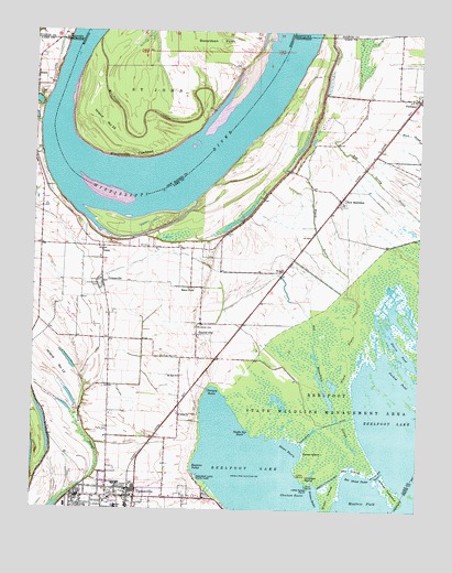
Tiptonville, TN USGS Topographic Map
Click on map above to begin viewing in our Map Viewer.

This topographic map contains these locations and features:
Feature Name Type Latitude Longitude GNIS ID View Map
Bee Tree SloughGutN36.4201°W89.3867°1311385View Map
BessiePopulated PlaceN36.4881°W89.4995°1277071View Map
Bessie LandingLocaleN36.4878°W89.4931°1319159View Map
Big Ronaldson SloughStreamN36.3856°W89.3884°1277378View Map
Black BayouStreamN36.3998°W89.4006°1277539View Map
Buckelew CemeteryCemeteryN36.4228°W89.4462°1278844View Map
Calhoun Boat DockLocaleN36.4065°W89.4431°1319161View Map
Caney IslandIslandN36.3901°W89.4090°1279592View Map
CatesPopulated PlaceN36.4437°W89.4776°1279880View Map
Cates LandingLocaleN36.4467°W89.4754°1319162View Map
Cates School (historical)SchoolN36.4440°W89.4823°1319163View Map
Champey PocketBayN36.4059°W89.4412°1280225View Map
Choctaw BasinBayN36.3787°W89.4137°1280505View Map
Choctaw IslandIslandN36.3840°W89.4112°1280506View Map
Citizen CemeteryCemeteryN36.3809°W89.4709°1280571View Map
Commissioner District 1CivilN36.4362°W89.4407°2464253View Map
Cook Pond (historical)LakeN36.4473°W89.4898°1311391View Map
Coot SloughLakeN36.3944°W89.3982°1311392View Map
CronanvillePopulated PlaceN36.4345°W89.4773°1306185View Map
Cronanville CemeteryCemeteryN36.4337°W89.4784°1281656View Map
Cronanville Cumberland Presbyterian ChurchChurchN36.4345°W89.4795°1319170View Map
Dellas TowheadBarN36.3784°W89.4001°1311393View Map
Donaldson PointCapeN36.4926°W89.4565°716974View Map
Estes PondPopulated PlaceN36.4331°W89.4490°1315027View Map
Forked PondBayN36.4098°W89.3809°1284642View Map
Free Will CemeteryCemeteryN36.4151°W89.4576°1284877View Map
Free Will Church (historical)ChurchN36.4151°W89.4595°1319172View Map
Goochs CampLocaleN36.3792°W89.4390°1319174View Map
Goochs LandingLocaleN36.3781°W89.4348°1319175View Map
Grassy BendBendN36.4217°W89.3862°1311397View Map
Gray Duck HoleLakeN36.4192°W89.3756°1311399View Map
Green IslandIslandN36.3784°W89.4029°1269605View Map
Green Island CutoffCanalN36.3831°W89.4029°1286107View Map
Grooms PocketBayN36.3798°W89.4079°1286340View Map
Island Number 10IslandN36.4756°W89.4779°755227View Map
Island Number Nine RevetmentLeveeN36.4890°W89.4140°1311406View Map
Island Number TenIslandN36.4667°W89.4667°736180View Map
Island Number TwelveFlatN36.4126°W89.4926°1289090View Map
Katies GourdLakeN36.4231°W89.3770°1311407View Map
Keystone PocketBayN36.3862°W89.4470°1290134View Map
Lake County CourthouseBuildingN36.3781°W89.4840°1319184View Map
Lake County Emergency Medical ServicesBuildingN36.3811°W89.4666°2697415View Map
Lake County High SchoolSchoolN36.3756°W89.4726°1319185View Map
Lake County Sheriff's OfficeBuildingN36.3781°W89.4841°2765985View Map
Lake County Shopping CenterLocaleN36.3770°W89.4667°1319187View Map
Lambs BarBarN36.3892°W89.4456°1311408View Map
Little Caney PointCapeN36.3815°W89.4101°1291415View Map
Margaret Newton Elementary SchoolSchoolN36.3777°W89.4748°1319193View Map
Moultrie FieldBayN36.3776°W89.3926°1294536View Map
Mount Zion ChurchChurchN36.4098°W89.4523°1294914View Map
Needle Eye BasinBayN36.3951°W89.4295°1295302View Map
New MarkhamPopulated PlaceN36.4559°W89.4006°1295603View Map
Northwest Correctional ComplexBuildingN36.4157°W89.4533°2766072View Map
Old Slough Landing (historical)LocaleN36.4465°W89.4640°1319198View Map
Parks CemeteryCemeteryN36.3953°W89.4753°1296851View Map
PhillippyPopulated PlaceN36.4828°W89.3762°1297327View Map
Phillippy Baptist ChurchChurchN36.4826°W89.3784°1319200View Map
Phillippy School (historical)SchoolN36.4826°W89.3790°1319201View Map
Proctor CityPopulated PlaceN36.4206°W89.4465°1298559View Map
Race TrackLocaleN36.3967°W89.3876°1319202View Map
Rag PointCapeN36.4128°W89.3787°1647499View Map
Rat IslandIslandN36.3862°W89.3965°1298931View Map
Rat Island PocketBayN36.3834°W89.3945°1298932View Map
Rays CampLocaleN36.3823°W89.4459°1319203View Map
Reading House SloughLakeN36.4019°W89.3825°1311842View Map
Reelfoot State Wildlife Management AreaParkN36.3995°W89.4040°1269889View Map
Saint Johns ChurchChurchN36.4001°W89.4526°1300452View Map
Slough BendBendN36.4570°W89.4731°1311425View Map
Slough Landing Neck RevetmentLeveeN36.4631°W89.4959°1311427View Map
Staen HoleLakeN36.4059°W89.4049°1311429View Map
Starve PondLakeN36.4170°W89.3809°1271269View Map
Swan BasinBayN36.3909°W89.4159°1271934View Map
TiptonvillePopulated PlaceN36.3784°W89.4720°1272690View Map
Tiptonville City HallBuildingN36.3781°W89.4831°1319210View Map
Tiptonville Division (historical)CensusN36.3809°W89.4690°1648813View Map
Tiptonville Fire DepartmentBuildingN36.3800°W89.4665°2653657View Map
Tiptonville First Baptist ChurchChurchN36.3787°W89.4781°1319211View Map
Tiptonville Police DepartmentBuildingN36.3782°W89.4852°2765771View Map
Tiptonville Post OfficePost OfficeN36.3786°W89.4823°1651206View Map
Tiptonville Public LibraryBuildingN36.3792°W89.4776°1319212View Map
Town of TiptonvilleCivilN36.3765°W89.4718°2406738View Map
Watson Point DikeLeveeN36.4548°W89.4920°1311433View Map
Willow Bar CutoffChannelN36.3845°W89.3873°1304615View Map
Willow TowheadIslandN36.3806°W89.3837°1304623View Map
Winchester ChuteStreamN36.4981°W89.4792°728990View Map
Winchester TowheadBendN36.4678°W89.4679°728991View Map
WrightPopulated PlaceN36.4373°W89.4187°1314538View Map

Note: Coordinates in the location and feature list above are referenced to NAD83 datum.


Copyright (C) 2008-2024 Ryan Niemi / Sunset Dynamics ... All Rights Reserved