TopoQuest Logo
Do you find TopoQuest useful?
Help keep TopoQuest running and adding new maps/features by donating!
Bitcoin:  19c7KJd3qBynnjoSw5npx9KScwjBe4ifkT
Litecoin:  LXs6TkuXGGXo1vDsWCkWVdjQX94eUKd6ui
Home View Maps Find Maps Find Places Resources & Links


South Vienna, Ohio Topographic Map

USGS Map Title: South Vienna, OH
USGS Map MRC: 39083H5
DRG (GeoTIFF) Download: o39083h5.tif


Neighboring USGS Topographic Map Quads:


  Urbana East, OH  
40083A6
 

  Mechanicsburg, OH  
40083A5
 

  Plumwood, OH  
40083A4
 

  New Moorefield, OH  
39083H6
 

  South Vienna, OH  
39083H5
 

  London, OH  
39083H4
 

  South Charleston, OH  
39083G6
 

  Florence, OH  
39083G5
 

  Walnut Run, OH  
39083G4


Map MRC Location:

N40°
W84°
N40°
W83°
H8 H7 H6 H5 H4 H3 H2 H1
G8 G7 G6 G5 G4 G3 G2 G1
F8 F7 F6 F5 F4 F3 F2 F1
E8 E7 E6 E5 E4 E3 E2 E1
D8 D7 D6 D5 D4 D3 D2 D1
C8 C7 C6 C5 C4 C3 C2 C1
B8 B7 B6 B5 B4 B3 B2 B1
A8 A7 A6 A5 A4 A3 A2 A1
N39°
W84°
N39°
W83°

South Vienna, OH USGS 1:24K Topographic Map Preview:
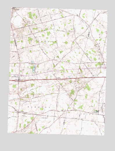
South Vienna, OH USGS Topographic Map
Click on map above to begin viewing in our Map Viewer.

This topographic map contains these locations and features:
Feature Name Type Latitude Longitude GNIS ID View Map
Baker FarmsLocaleN39.8912°W83.5014°2729981View Map
Bar FarmsLocaleN39.9132°W83.5058°2729982View Map
Bodkin CemeteryCemeteryN39.9713°W83.5931°1038168View Map
BrightonPopulated PlaceN39.9301°W83.5613°1064491View Map
Brighton CemeteryCemeteryN39.9345°W83.5683°1038313View Map
CatawbaPopulated PlaceN39.9992°W83.6216°1056775View Map
Catawba Post OfficePost OfficeN39.9987°W83.6221°1966297View Map
Catawba SchoolSchoolN39.9964°W83.6233°1051370View Map
George C Wilson DitchCanalN39.8906°W83.5738°1040816View Map
Gill Livestock and Land FarmsLocaleN39.8856°W83.5332°2729991View Map
Harmony Township Fire DepartmentBuildingN39.9292°W83.5988°2550167View Map
Interchange 66CrossingN39.9326°W83.6121°1061292View Map
Lake SylvanReservoirN39.9397°W83.5928°1077678View Map
Lake Sylvan DamDamN39.9358°W83.5929°1077677View Map
London Fish HatcheryLocaleN39.8984°W83.5096°1068820View Map
Markley (historical)Populated PlaceN39.9326°W83.5152°1067461View Map
McConkey CemeteryCemeteryN39.9851°W83.6041°1043093View Map
Myers (historical)Populated PlaceN39.8903°W83.5291°1063392View Map
North Fork Deer CreekStreamN39.9464°W83.5035°1043941View Map
Oakgrove School (historical)SchoolN39.9637°W83.5458°1051406View Map
Pelz Field Airport (historical)AirportN39.9854°W83.6091°1083023View Map
PlattsburgPopulated PlaceN39.8962°W83.6116°1085482View Map
Plattsburg CemeteryCemeteryN39.8939°W83.6038°1961172View Map
Plattsburg Post Office (historical)Post OfficeN39.8962°W83.6116°1983751View Map
Pleasant Hill CemeteryCemeteryN39.9442°W83.5958°1044543View Map
Pleasant Township Fire DepartmentBuildingN39.9989°W83.6217°2550164View Map
Reaver Farms OrchardLocaleN39.8939°W83.5589°2516120View Map
Sanford FarmLocaleN39.9843°W83.5235°2730008View Map
Somerford CemeteryCemeteryN39.9453°W83.5038°1046428View Map
South ViennaPopulated PlaceN39.9270°W83.6124°1058101View Map
South Vienna Elementary SchoolSchoolN39.9284°W83.6152°1061293View Map
South Vienna Post OfficePost OfficeN39.9278°W83.6124°1966295View Map
Statler CemeteryCemeteryN39.9658°W83.5122°1046656View Map
Sylvan ShoresPopulated PlaceN39.9398°W83.5910°1051416View Map
Township of PleasantCivilN39.9781°W83.5990°1085858View Map
Village of CatawbaCivilN39.9995°W83.6228°2397575View Map
Village of South ViennaCivilN39.9294°W83.6134°2399860View Map
W G Wilson DitchCanalN39.9148°W83.5905°1047475View Map
Wilson ChapelChurchN39.8981°W83.5544°1047979View Map
Wilson Chapel CemeteryCemeteryN39.8980°W83.5546°1068736View Map

Note: Coordinates in the location and feature list above are referenced to NAD83 datum.


Copyright (C) 2008-2024 Ryan Niemi / Sunset Dynamics ... All Rights Reserved