TopoQuest Logo
Do you find TopoQuest useful?
Help keep TopoQuest running and adding new maps/features by donating!
Bitcoin:  19c7KJd3qBynnjoSw5npx9KScwjBe4ifkT
Litecoin:  LXs6TkuXGGXo1vDsWCkWVdjQX94eUKd6ui
Home View Maps Find Maps Find Places Resources & Links


New Ringgold, Pennsylvania Topographic Map

USGS Map Title: New Ringgold, PA
USGS Map MRC: 40075F8
DRG (GeoTIFF) Download: o40075f8.tif


Neighboring USGS Topographic Map Quads:


  Delano, PA  
40076G1
 

  Tamaqua, PA  
40075G8
 

  Nesquehoning, PA  
40075G7
 

  Orwigsburg, PA  
40076F1
 

  New Ringgold, PA  
40075F8
 

  New Tripoli, PA  
40075F7
 

  Auburn, PA  
40076E1
 

  Hamburg, PA  
40075E8
 

  Kutztown, PA  
40075E7


Map MRC Location:

N41°
W76°
N41°
W75°
H8 H7 H6 H5 H4 H3 H2 H1
G8 G7 G6 G5 G4 G3 G2 G1
F8 F7 F6 F5 F4 F3 F2 F1
E8 E7 E6 E5 E4 E3 E2 E1
D8 D7 D6 D5 D4 D3 D2 D1
C8 C7 C6 C5 C4 C3 C2 C1
B8 B7 B6 B5 B4 B3 B2 B1
A8 A7 A6 A5 A4 A3 A2 A1
N40°
W76°
N40°
W75°

New Ringgold, PA USGS 1:24K Topographic Map Preview:
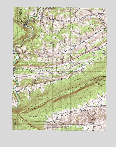
New Ringgold, PA USGS Topographic Map
Click on map above to begin viewing in our Map Viewer.

This topographic map contains these locations and features:
Feature Name Type Latitude Longitude GNIS ID View Map
Appalachian OverlookLocaleN40.6371°W75.9869°2487740View Map
Atlas ParkParkN40.7387°W75.9688°1168491View Map
Bald LookoutLocaleN40.6389°W75.9902°2487748View Map
Bolich ChurchChurchN40.6359°W75.9394°1169960View Map
Bolich's CemeteryCemeteryN40.6361°W75.9392°2776202View Map
Borough of New RinggoldCivilN40.6892°W75.9928°1215560View Map
Brushy RunStreamN40.7318°W75.9833°1170478View Map
ChainPopulated PlaceN40.7376°W75.9452°1203243View Map
CobbleSummitN40.6318°W75.9910°1172093View Map
Community Fire Company New Ringgold District 55 Station 1BuildingN40.6873°W75.9997°2652995View Map
Dans PulpitSummitN40.6593°W75.9424°1172925View Map
Deep Hollow RunStreamN40.7069°W75.9994°2071338View Map
DorsetPopulated PlaceN40.7023°W75.8760°1203435View Map
Dorset SchoolSchoolN40.7065°W75.8780°1173402View Map
EckvillePopulated PlaceN40.6329°W75.9527°1203492View Map
Hawk MountainSummitN40.6456°W75.9799°1192591View Map
Hawk Mountain SanctuaryParkN40.6409°W75.9922°1176665View Map
Hawk Mountain Sanctuary Visitors CenterBuildingN40.6341°W75.9872°2488791View Map
Heinrich 3 CemeteryCemeteryN40.6308°W75.9271°2776322View Map
Hemlock HeightsSummitN40.6287°W75.9749°1176805View Map
Indian RunStreamN40.6620°W75.9938°1177775View Map
Keenigs CreekStreamN40.7020°W75.9933°1202625View Map
KepnerPopulated PlaceN40.6970°W75.9199°1203934View Map
Koenigs CreekStreamN40.6748°W75.9944°1178634View Map
Koenigs Creek DamDamN40.6901°W75.9330°1194985View Map
Mountain SchoolSchoolN40.6504°W75.8821°1192980View Map
New Bethel SchoolSchoolN40.6326°W75.8924°1182287View Map
New Bethel Union CemeteryCemeteryN40.6328°W75.8918°2488693View Map
New Bethel Union ChurchChurchN40.6325°W75.8919°2488694View Map
New RinggoldPopulated PlaceN40.6859°W75.9991°1182363View Map
New Ringgold AmbulanceBuildingN40.6872°W75.9996°2722309View Map
New Ringgold Post OfficePost OfficeN40.6875°W75.9997°2773225View Map
North LookoutSummitN40.6409°W75.9922°1201483View Map
Owls HeadSummitN40.6256°W75.9652°1183161View Map
Penn Mahoning AmbulanceBuildingN40.7353°W75.8814°2722308View Map
Quaker CityPopulated PlaceN40.6595°W75.8788°1184518View Map
RauschsPopulated PlaceN40.6645°W75.9924°1184707View Map
Red ValleyValleyN40.6620°W75.9933°1184800View Map
Rene MontPopulated PlaceN40.6781°W75.9666°1204489View Map
ReynoldsPopulated PlaceN40.7409°W75.9741°1184967View Map
Ridge OverlookLocaleN40.6382°W75.9891°2488380View Map
River of RocksPillarN40.6381°W75.9713°1185123View Map
River of Rocks OverlookLocaleN40.6376°W75.9878°2488385View Map
River of Rocks TrailTrailN40.6376°W75.9759°2488386View Map
Sassamans SchoolSchoolN40.7104°W75.9158°1186994View Map
Snyders Evangelical CemeteryCemeteryN40.6423°W75.9233°2776308View Map
South LookoutLocaleN40.6359°W75.9855°1206818View Map
State Game Lands Number 106ParkN40.6609°W75.9266°1190992View Map
Steigerwalts SchoolSchoolN40.7431°W75.8819°1188596View Map
Stump RunStreamN40.7395°W75.9769°1188907View Map
Township of AlbanyCivilN40.6263°W75.8930°1215912View Map
Township of East BrunswickCivilN40.6792°W75.9867°1216997View Map
Township of West PennCivilN40.7417°W75.8768°1217026View Map
WebsterPopulated PlaceN40.7320°W75.9849°1190757View Map
West PennPopulated PlaceN40.7409°W75.9610°1191089View Map
West Penn ChurchChurchN40.7084°W75.8841°1191090View Map
West Penn Township AirportAirportN40.7465°W75.9317°2443029View Map
Zions ChurchChurchN40.7279°W75.8774°1192023View Map

Note: Coordinates in the location and feature list above are referenced to NAD83 datum.


Copyright (C) 2008-2025 Ryan Niemi / Sunset Dynamics ... All Rights Reserved