TopoQuest Logo
Do you find TopoQuest useful?
Help keep TopoQuest running and adding new maps/features by donating!
Bitcoin:  19c7KJd3qBynnjoSw5npx9KScwjBe4ifkT
Litecoin:  LXs6TkuXGGXo1vDsWCkWVdjQX94eUKd6ui
Home View Maps Find Maps Find Places Resources & Links


New Salem, Indiana Topographic Map

USGS Map Title: New Salem, IN
USGS Map MRC: 39085E3
DRG (GeoTIFF) Download: o39085e3.tif


Neighboring USGS Topographic Map Quads:


  Mays, IN  
39085F4
 

  Falmouth, IN  
39085F3
 

  Connersville, IN  
39085F2
 

  Rushville, IN  
39085E4
 

  New Salem, IN  
39085E3
 

  Alpine, IN  
39085E2
 

  Milroy, IN  
39085D4
 

  Clarksburg, IN  
39085D3
 

  Metamora, IN  
39085D2


Map MRC Location:

N40°
W86°
N40°
W85°
H8 H7 H6 H5 H4 H3 H2 H1
G8 G7 G6 G5 G4 G3 G2 G1
F8 F7 F6 F5 F4 F3 F2 F1
E8 E7 E6 E5 E4 E3 E2 E1
D8 D7 D6 D5 D4 D3 D2 D1
C8 C7 C6 C5 C4 C3 C2 C1
B8 B7 B6 B5 B4 B3 B2 B1
A8 A7 A6 A5 A4 A3 A2 A1
N39°
W86°
N39°
W85°

New Salem, IN USGS 1:24K Topographic Map Preview:
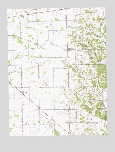
New Salem, IN USGS Topographic Map
Click on map above to begin viewing in our Map Viewer.

This topographic map contains these locations and features:
Feature Name Type Latitude Longitude GNIS ID View Map
Bever CemeteryCemeteryN39.5700°W85.2792°2709518View Map
FarmingtonPopulated PlaceN39.6181°W85.3589°434407View Map
Glenwood Volunteer Fire DepartmentBuildingN39.6248°W85.3004°2625999View Map
Gregg CemeteryCemeteryN39.5855°W85.3314°435476View Map
Heaton CemeteryCemeteryN39.5766°W85.3187°435956View Map
Hilltop CemeteryCemeteryN39.5314°W85.2558°2710396View Map
Little Flatrock ChurchChurchN39.5778°W85.3594°438057View Map
Little Salt Creek CemeteryCemeteryN39.5123°W85.2991°438142View Map
MauzyPopulated PlaceN39.6239°W85.3383°438744View Map
McMinn AirportAirportN39.5312°W85.3345°2676973View Map
New SalemPopulated PlaceN39.5423°W85.3580°440109View Map
New Salem Elementary and Junior High SchoolSchoolN39.5442°W85.3600°447130View Map
Old Brick CemeteryCemeteryN39.5000°W85.2791°440543View Map
Old Friends Church CemeteryCemeteryN39.6061°W85.2984°440558View Map
Old Orange CemeteryCemeteryN39.5838°W85.2898°2710397View Map
OrangePopulated PlaceN39.5842°W85.2991°440676View Map
Orange CemeteryCemeteryN39.5981°W85.2986°440678View Map
Sanes Creek ChurchChurchN39.5289°W85.2527°443016View Map
Township of NobleCivilN39.5680°W85.3508°453673View Map
Township of OrangeCivilN39.5766°W85.2707°453689View Map
Woodland Retreat DamDamN39.5217°W85.2550°447680View Map
Woodland Retreat LakeReservoirN39.5210°W85.2555°447681View Map

Note: Coordinates in the location and feature list above are referenced to NAD83 datum.


Copyright (C) 2008-2024 Ryan Niemi / Sunset Dynamics ... All Rights Reserved