TopoQuest Logo
Do you find TopoQuest useful?
Help keep TopoQuest running and adding new maps/features by donating!
Bitcoin:  19c7KJd3qBynnjoSw5npx9KScwjBe4ifkT
Litecoin:  LXs6TkuXGGXo1vDsWCkWVdjQX94eUKd6ui
Home View Maps Find Maps Find Places Resources & Links


Metamora, Indiana Topographic Map

USGS Map Title: Metamora, IN
USGS Map MRC: 39085D2
DRG (GeoTIFF) Download: o39085d2.tif


Neighboring USGS Topographic Map Quads:


  New Salem, IN  
39085E3
 

  Alpine, IN  
39085E2
 

  Everton, IN  
39085E1
 

  Clarksburg, IN  
39085D3
 

  Metamora, IN  
39085D2
 

  Brookville, IN  
39085D1
 

  New Point, IN  
39085C3
 

  Batesville, IN  
39085C2
 

  Spades, IN  
39085C1


Map MRC Location:

N40°
W86°
N40°
W85°
H8 H7 H6 H5 H4 H3 H2 H1
G8 G7 G6 G5 G4 G3 G2 G1
F8 F7 F6 F5 F4 F3 F2 F1
E8 E7 E6 E5 E4 E3 E2 E1
D8 D7 D6 D5 D4 D3 D2 D1
C8 C7 C6 C5 C4 C3 C2 C1
B8 B7 B6 B5 B4 B3 B2 B1
A8 A7 A6 A5 A4 A3 A2 A1
N39°
W86°
N39°
W85°

Metamora, IN USGS 1:24K Topographic Map Preview:
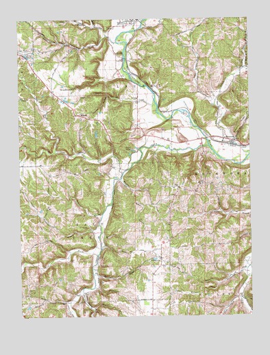
Metamora, IN USGS Topographic Map
Click on map above to begin viewing in our Map Viewer.

This topographic map contains these locations and features:
Feature Name Type Latitude Longitude GNIS ID View Map
Bachelors RunStreamN39.3870°W85.2105°430387View Map
Baker BranchStreamN39.4281°W85.1886°430420View Map
Barnes CemeteryCemeteryN39.3987°W85.2233°430500View Map
Bowman CemeteryCemeteryN39.4128°W85.2136°431407View Map
Brown BranchStreamN39.3781°W85.2111°431594View Map
Bull ForkStreamN39.4012°W85.2083°431789View Map
Canal LakesReservoirN39.4851°W85.2462°432100View Map
Clear ForkStreamN39.3826°W85.1314°432621View Map
Coalpit HollowValleyN39.4683°W85.2023°432713View Map
Cupp ChurchChurchN39.4298°W85.1641°449787View Map
Derbyshire FallsFallsN39.4717°W85.2208°433490View Map
Dodson BranchStreamN39.4181°W85.2055°433598View Map
Dry BranchStreamN39.4967°W85.2077°433710View Map
Fremont BranchStreamN39.4139°W85.2075°434825View Map
Gap School (historical)SchoolN39.4542°W85.1839°449781View Map
Gemco LakeReservoirN39.4519°W85.2080°447228View Map
Gemco Lake DamDamN39.4517°W85.2083°447227View Map
Gobel CemeteryCemeteryN39.4537°W85.1708°435144View Map
Halls HollowValleyN39.4682°W85.2024°435624View Map
Hamburg BranchStreamN39.3812°W85.2236°435631View Map
Harvey BranchStreamN39.3867°W85.2166°449789View Map
Holzhause Stone QuarryMineN39.4933°W85.2344°2649437View Map
Jackson HillSummitN39.4487°W85.1941°436892View Map
Jenks CemeteryCemeteryN39.4828°W85.1891°436987View Map
Jim RunStreamN39.4795°W85.1277°449790View Map
Kroeger BranchStreamN39.3831°W85.1305°437462View Map
Lake ViewPopulated PlaceN39.4856°W85.2483°437540View Map
Laurel Feeder DamDamN39.4837°W85.1925°437654View Map
Little Duck CreekStreamN39.4637°W85.1439°438048View Map
Little Salt CreekStreamN39.4445°W85.1930°438141View Map
Little Sanes CreekStreamN39.4934°W85.2025°449794View Map
Little Walnut ForkStreamN39.3889°W85.1422°438171View Map
Marlin BranchStreamN39.3931°W85.2111°438634View Map
Marlin CemeteryCemeteryN39.3948°W85.2086°438635View Map
McGuire RidgeRidgeN39.4562°W85.1289°438879View Map
MetamoraPopulated PlaceN39.4498°W85.1394°439045View Map
Metamora Census Designated PlaceCensusN39.4482°W85.1378°2587022View Map
Metamora Volunteer Fire DepartmentBuildingN39.4458°W85.1321°2626038View Map
MidwayPopulated PlaceN39.4598°W85.2166°439123View Map
PeppertownPopulated PlaceN39.3989°W85.1741°441012View Map
Pilgrim Holiness ChurchChurchN39.4276°W85.1547°449780View Map
Saint Annes CemeteryCemeteryN39.3850°W85.2458°442473View Map
Saint Nicholas CemeteryCemeteryN39.4025°W85.1786°442746View Map
Salt CreekStreamN39.4464°W85.1475°442941View Map
Sanes CreekStreamN39.4889°W85.1916°443015View Map
Sillimans CreekStreamN39.4645°W85.1758°443486View Map
South Fork Little Salt CreekStreamN39.4445°W85.2305°443809View Map
Stipps Hill CemeteryCemeteryN39.4364°W85.2252°444175View Map
Stips Hill Church (historical)ChurchN39.4359°W85.2247°449779View Map
Stips Hill School (historical)SchoolN39.4281°W85.2339°449778View Map
Swartz School (historical)SchoolN39.4220°W85.1811°449777View Map
Township of LaurelCivilN39.4864°W85.1902°453544View Map
Township of MetamoraCivilN39.4331°W85.1312°453618View Map
Township of Salt CreekCivilN39.4102°W85.2330°453827View Map
Triple LakesLakeN39.4432°W85.1898°444912View Map
Turner Stone QuarryMineN39.4661°W85.1797°2649815View Map
Walnut ForkStreamN39.3956°W85.1255°445417View Map
Whistle CreekStreamN39.4328°W85.1950°449803View Map
Wiley Indian MoundSummitN39.4962°W85.2019°446031View Map

Note: Coordinates in the location and feature list above are referenced to NAD83 datum.


Copyright (C) 2008-2025 Ryan Niemi / Sunset Dynamics ... All Rights Reserved