TopoQuest Logo
Do you find TopoQuest useful?
Help keep TopoQuest running and adding new maps/features by donating!
Bitcoin:  19c7KJd3qBynnjoSw5npx9KScwjBe4ifkT
Litecoin:  LXs6TkuXGGXo1vDsWCkWVdjQX94eUKd6ui
Home View Maps Find Maps Find Places Resources & Links


Bellemont, Arizona Topographic Map

USGS Map Title: Bellemont, AZ
USGS Map MRC: 35111B7
DRG (GeoTIFF) Download: o35111b7.tif


Neighboring USGS Topographic Map Quads:


  Parks, AZ  
35111C8
 

  Wing Mountain, AZ  
35111C7
 

  Humphreys Peak, AZ  
35111C6
 

  Garland Prairie, AZ  
35111B8
 

  Bellemont, AZ  
35111B7
 

  Flagstaff West, AZ  
35111B6
 

  Sycamore Point, AZ  
35111A8
 

  Dutton Hill, AZ  
35111A7
 

  Mountainaire, AZ  
35111A6


Map MRC Location:

N36°
W112°
N36°
W111°
H8 H7 H6 H5 H4 H3 H2 H1
G8 G7 G6 G5 G4 G3 G2 G1
F8 F7 F6 F5 F4 F3 F2 F1
E8 E7 E6 E5 E4 E3 E2 E1
D8 D7 D6 D5 D4 D3 D2 D1
C8 C7 C6 C5 C4 C3 C2 C1
B8 B7 B6 B5 B4 B3 B2 B1
A8 A7 A6 A5 A4 A3 A2 A1
N35°
W112°
N35°
W111°

Bellemont, AZ USGS 1:24K Topographic Map Preview:
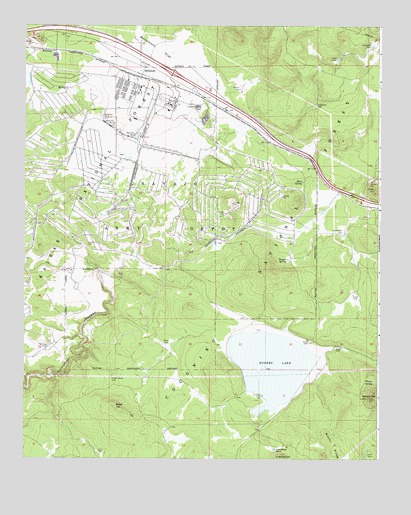
Bellemont, AZ USGS Topographic Map
Click on map above to begin viewing in our Map Viewer.

This topographic map contains these locations and features:
Feature Name Type Latitude Longitude GNIS ID View Map
A-One TankReservoirN35.2410°W111.7563°37606View Map
Aspen Spring RanchLocaleN35.1278°W111.7863°37618View Map
Aspen Spring TankReservoirN35.1276°W111.7870°37619View Map
Atherton LakeLakeN35.2106°W111.8396°2089785View Map
Auza TanksReservoirN35.1256°W111.7542°25849View Map
Bear TankReservoirN35.2331°W111.7816°37637View Map
BellemontPopulated PlaceN35.2381°W111.8335°26201View Map
Bellemont FlatReservoirN35.2394°W111.8232°26202View Map
Bellemont SidingLocaleN35.2353°W111.8352°37641View Map
Budweiser TankReservoirN35.1899°W111.7630°26937View Map
Camp NavajoMilitaryN35.1936°W111.8419°2512067View Map
Ebert SpringSpringN35.2486°W111.8607°2089782View Map
Elsie SpringSpringN35.2049°W111.7773°28897View Map
Fisher TankReservoirN35.1725°W111.7592°29029View Map
Fishers SpringSpringN35.1671°W111.7645°37783View Map
Hidden TankReservoirN35.2350°W111.7885°2089783View Map
Home TankReservoirN35.1588°W111.7749°30076View Map
Horse TankReservoirN35.1539°W111.8499°2089779View Map
Johnson TankReservoirN35.2314°W111.7997°2091552View Map
Junction TankReservoirN35.1393°W111.8647°37865View Map
Kelly TankReservoirN35.1661°W111.8452°2089781View Map
L TankReservoirN35.1873°W111.8080°37885View Map
Lake TankReservoirN35.1431°W111.7907°30850View Map
Lake TankReservoirN35.1875°W111.8079°30851View Map
Le Barron HillSummitN35.1250°W111.7832°30917View Map
Le Barron TankReservoirN35.2444°W111.7533°30918View Map
Marvin Spring (historical)SpringN35.2339°W111.7961°2089880View Map
Marvin TankReservoirN35.2318°W111.7996°31552View Map
Marvin TankReservoirN35.2153°W111.8122°2089881View Map
Metz TankReservoirN35.1302°W111.8251°37936View Map
Metz TankReservoirN35.1333°W111.8248°37937View Map
Metz TankReservoirN35.1579°W111.8262°31778View Map
Navajo InterchangeCrossingN35.2364°W111.8232°37965View Map
Paterson SpringSpringN35.1566°W111.8071°37982View Map
Ponderosa Fire District Station 82BuildingN35.2373°W111.8165°2672550View Map
Quarry TankReservoirN35.2017°W111.8263°2089784View Map
Railroad TankReservoirN35.1572°W111.8666°33333View Map
Ray TankReservoirN35.1253°W111.8046°38027View Map
Reservoir Number OneReservoirN35.2181°W111.8358°33585View Map
Reservoir Number ThreeReservoirN35.2232°W111.8470°33587View Map
Reservoir Number TwoReservoirN35.2213°W111.8439°33586View Map
Rogers LakeLakeN35.1522°W111.7878°33779View Map
Saddle Horse TankReservoirN35.1481°W111.8444°33924View Map
Sliker HillSummitN35.1481°W111.8443°34535View Map
Sliker TankReservoirN35.1271°W111.8491°38077View Map
Tappen SpringSpringN35.1824°W111.7827°35155View Map
Telephone TankReservoirN35.2273°W111.7730°41168View Map
Thompson TankReservoirN35.2479°W111.8216°38108View Map
Tree TankReservoirN35.1572°W111.7635°35454View Map
Turkey Number Three TankReservoirN35.2254°W111.7951°38126View Map
Twin TanksReservoirN35.2402°W111.7653°35635View Map
Woody MountainSummitN35.1420°W111.7516°36391View Map
Woody SpringSpringN35.1473°W111.7522°36393View Map

Note: Coordinates in the location and feature list above are referenced to NAD83 datum.


Copyright (C) 2008-2024 Ryan Niemi / Sunset Dynamics ... All Rights Reserved