TopoQuest Logo
Do you find TopoQuest useful?
Help keep TopoQuest running and adding new maps/features by donating!
Bitcoin:  19c7KJd3qBynnjoSw5npx9KScwjBe4ifkT
Litecoin:  LXs6TkuXGGXo1vDsWCkWVdjQX94eUKd6ui
Home View Maps Find Maps Find Places Resources & Links


Humphreys Peak, Arizona Topographic Map

USGS Map Title: Humphreys Peak, AZ
USGS Map MRC: 35111C6
DRG (GeoTIFF) Download: o35111c6.tif


Neighboring USGS Topographic Map Quads:


  Kendrick Peak, AZ  
35111D7
 

  White Horse Hills, AZ  
35111D6
 

  O'Leary Peak, AZ  
35111D5
 

  Wing Mountain, AZ  
35111C7
 

  Humphreys Peak, AZ  
35111C6
 

  Sunset Crater West, AZ  
35111C5
 

  Bellemont, AZ  
35111B7
 

  Flagstaff West, AZ  
35111B6
 

  Flagstaff East, AZ  
35111B5


Map MRC Location:

N36°
W112°
N36°
W111°
H8 H7 H6 H5 H4 H3 H2 H1
G8 G7 G6 G5 G4 G3 G2 G1
F8 F7 F6 F5 F4 F3 F2 F1
E8 E7 E6 E5 E4 E3 E2 E1
D8 D7 D6 D5 D4 D3 D2 D1
C8 C7 C6 C5 C4 C3 C2 C1
B8 B7 B6 B5 B4 B3 B2 B1
A8 A7 A6 A5 A4 A3 A2 A1
N35°
W112°
N35°
W111°

Humphreys Peak, AZ USGS 1:24K Topographic Map Preview:
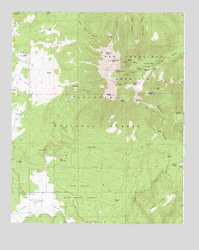
Humphreys Peak, AZ USGS Topographic Map
Click on map above to begin viewing in our Map Viewer.

This topographic map contains these locations and features:
Feature Name Type Latitude Longitude GNIS ID View Map
Agassiz PeakSummitN35.3258°W111.6779°25531View Map
Alfa Fia TankReservoirN35.3222°W111.7238°37608View Map
Arizona Snow BowlLocaleN35.3303°W111.7060°25748View Map
Arizona Snow Bowl CampgroundLocaleN35.3308°W111.7104°41177View Map
Aspen SpringSpringN35.3045°W111.6449°25827View Map
Aspen TankReservoirN35.3111°W111.6391°37622View Map
Aubineau PeakSummitN35.3553°W111.6599°25435View Map
Bear Paw SpringSpringN35.3425°W111.6596°26100View Map
Beard CanyonValleyN35.3431°W111.6552°26137View Map
Beard SpringSpringN35.3459°W111.6660°26138View Map
Big Leroux SpringSpringN35.2932°W111.7249°37646View Map
Bismarck LakeReservoirN35.3644°W111.7211°26360View Map
Bismarck TankReservoirN35.3628°W111.7163°41189View Map
Chimney SpringSpringN35.2637°W111.6751°27594View Map
Domingo TankReservoirN35.3419°W111.7339°37752View Map
Doyle PeakSummitN35.3300°W111.6463°28586View Map
Doyle SaddleGapN35.3228°W111.6718°28587View Map
Doyle SpringSpringN35.3321°W111.6598°28588View Map
Dry Lake HillsSummitN35.2661°W111.6371°28632View Map
Fern MountainSummitN35.3489°W111.7393°28975View Map
Fern Mountain TankReservoirN35.3528°W111.7367°37782View Map
Flagstaff SpringSpringN35.3398°W111.6681°29053View Map
Fort Valley Census Designated PlaceCensusN35.2554°W111.7253°2582786View Map
Fort Valley Experimental ForestForestN35.2692°W111.7007°29121View Map
Fort Valley Experimental Forest StationLocaleN35.2672°W111.7427°29122View Map
Freidlein PrairieFlatN35.2945°W111.6924°29183View Map
Freidlein Prairie TankReservoirN35.2946°W111.6924°41192View Map
Fremont PeakSummitN35.3231°W111.6610°29185View Map
Fremont SaddleGapN35.3270°W111.6518°29187View Map
G. A. Pearson Natural AreaParkN35.2711°W111.7454°41187View Map
Galinas TankReservoirN35.3266°W111.7387°37810View Map
Hart PrairieFlatN35.3331°W111.7421°29772View Map
Hart Prairie TankReservoirN35.3139°W111.7420°29773View Map
High TankReservoirN35.3121°W111.6289°41191View Map
High TankReservoirN35.3061°W111.6263°37831View Map
Hot Shot HeadquartersBuildingN35.2870°W111.7249°37843View Map
Humphreys PeakSummitN35.3463°W111.6780°30290View Map
Inner BasinBasinN35.3420°W111.6524°30389View Map
Jack Smith SpringSpringN35.3449°W111.6476°37853View Map
Kachina Peaks WildernessReserveN35.3380°W111.6640°41174View Map
Leroux SpringSpringN35.2933°W111.7249°26271View Map
Lew TankReservoirN35.3564°W111.7182°30956View Map
Little Leroux SpringSpringN35.2874°W111.7150°31093View Map
Little SpringSpringN35.3746°W111.7253°31130View Map
Meadow TankReservoirN35.3083°W111.6440°41194View Map
Michelbach RanchLocaleN35.3292°W111.7482°31796View Map
Orion SpringSpringN35.2899°W111.6371°32554View Map
Philomena SpringSpringN35.3502°W111.6822°32849View Map
Raspberry SpringSpringN35.3416°W111.6485°33384View Map
Rees PeakSummitN35.3558°W111.6518°33555View Map
San Francisco MountainSummitN35.3408°W111.6832°34010View Map
San Francisco Peaks Natural AreaParkN35.3531°W111.6943°38052View Map
Schultz PassGapN35.2847°W111.6321°34154View Map
Schultz PeakSummitN35.3156°W111.6315°34156View Map
Schultz TankReservoirN35.2851°W111.6267°34157View Map
Snowbowl Ski AreaLocaleN35.3278°W111.6952°41188View Map
Snowslide SpringSpringN35.3321°W111.6703°34594View Map
Summit Fire District Station 36BuildingN35.2614°W111.7373°2672638View Map
Taylor SpringSpringN35.2893°W111.7464°35167View Map
Viet SpringSpringN35.3065°W111.7128°38142View Map
Windmill TankReservoirN35.3564°W111.7474°38189View Map
Windmill TankReservoirN35.3584°W111.7354°41190View Map

Note: Coordinates in the location and feature list above are referenced to NAD83 datum.


Copyright (C) 2008-2025 Ryan Niemi / Sunset Dynamics ... All Rights Reserved