TopoQuest Logo
Do you find TopoQuest useful?
Help keep TopoQuest running and adding new maps/features by donating!
Bitcoin:  19c7KJd3qBynnjoSw5npx9KScwjBe4ifkT
Litecoin:  LXs6TkuXGGXo1vDsWCkWVdjQX94eUKd6ui
Home View Maps Find Maps Find Places Resources & Links


Newark Valley, New York Topographic Map

USGS Map Title: Newark Valley, NY
USGS Map MRC: 42076B2
DRG (GeoTIFF) Download: o42076b2.tif


Neighboring USGS Topographic Map Quads:


  Speedsville, NY  
42076C3
 

  Richford, NY  
42076C2
 

  Lisle, NY  
42076C1
 

  Candor, NY  
42076B3
 

  Newark Valley, NY  
42076B2
 

  Maine, NY  
42076B1
 

  Owego, NY  
42076A3
 

  Apalachin, NY  
42076A2
 

  Endicott, NY  
42076A1


Map MRC Location:

N43°
W77°
N43°
W76°
H8 H7 H6 H5 H4 H3 H2 H1
G8 G7 G6 G5 G4 G3 G2 G1
F8 F7 F6 F5 F4 F3 F2 F1
E8 E7 E6 E5 E4 E3 E2 E1
D8 D7 D6 D5 D4 D3 D2 D1
C8 C7 C6 C5 C4 C3 C2 C1
B8 B7 B6 B5 B4 B3 B2 B1
A8 A7 A6 A5 A4 A3 A2 A1
N42°
W77°
N42°
W76°

Newark Valley, NY USGS 1:24K Topographic Map Preview:
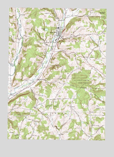
Newark Valley, NY USGS Topographic Map
Click on map above to begin viewing in our Map Viewer.

This topographic map contains these locations and features:
Feature Name Type Latitude Longitude GNIS ID View Map
Alexander LakeReservoirN42.2295°W76.2017°942306View Map
Doolittle CreekStreamN42.1945°W76.2413°948577View Map
East Beecher Hill Community ClubLocaleN42.1292°W76.2349°974370View Map
East NewarkPopulated PlaceN42.2034°W76.1483°972425View Map
First Baptist ChurchChurchN42.2275°W76.1856°2507513View Map
First Congregational Church of ChristChurchN42.2222°W76.1853°2507514View Map
First United Methodist Church of Newark ValleyChurchN42.2203°W76.1859°2616023View Map
FlemingvillePopulated PlaceN42.1648°W76.2488°950278View Map
Flemingville CemeteryCemeteryN42.1661°W76.2460°2504880View Map
Flemingville United Methodist ChurchChurchN42.1664°W76.2467°2504868View Map
FosterPopulated PlaceN42.1292°W76.1433°950512View Map
GaskillPopulated PlaceN42.1301°W76.1816°950932View Map
Holden PondLakeN42.1557°W76.2131°952982View Map
Hope CemeteryCemeteryN42.2113°W76.1899°2507522View Map
HullsvillePopulated PlaceN42.1565°W76.1688°953427View Map
Nathan T Hall Elementary SchoolSchoolN42.2304°W76.1863°952056View Map
Newark ValleyPopulated PlaceN42.2237°W76.1833°958490View Map
Newark Valley Depot MuseumBuildingN42.2256°W76.1856°2507649View Map
Newark Valley Fire DepartmentBuildingN42.2081°W76.1934°2701210View Map
Newark Valley Middle SchoolSchoolN42.2315°W76.1860°946283View Map
Newark Valley Post OfficePost OfficeN42.2231°W76.1832°2618038View Map
Newark Valley Senior High SchoolSchoolN42.2400°W76.1753°2507536View Map
Newark Valley Village GreenParkN42.2233°W76.1839°2507650View Map
Northern Tioga Family Health CenterHospitalN42.2322°W76.1850°2507673View Map
Oakley CornersLocaleN42.1748°W76.1563°959177View Map
Oakley Corners State ForestForestN42.1804°W76.1547°959178View Map
Pleasant Valley CemeteryCemeteryN42.2216°W76.2347°960730View Map
Saint John The Evangelist ChurchChurchN42.2223°W76.1810°963650View Map
Saint Johns CemeteryCemeteryN42.2235°W76.1646°963603View Map
Saint Maximus Orthodox Christian ChurchChurchN42.1288°W76.1811°2616984View Map
Searlestown CemeteryCemeteryN42.1749°W76.2243°2504885View Map
Settle CemeteryCemeteryN42.2191°W76.1330°2507523View Map
Spencer - Kozanosky PitMineN42.1719°W76.2347°2712443View Map
Tappan - Spaulding Memorial LibraryBuildingN42.2235°W76.1831°2617439View Map
Town of Newark ValleyCivilN42.2303°W76.1630°979254View Map
Tri-K FarmsLocaleN42.1667°W76.2489°2517009View Map
Trout Ponds ParkParkN42.2211°W76.1933°2507651View Map
Valley Mobile Home ParkPopulated PlaceN42.1733°W76.2303°2507634View Map
Village of Newark ValleyCivilN42.2229°W76.1868°2391016View Map
WeltonvillePopulated PlaceN42.1965°W76.2466°969060View Map
Weltonville CemeteryCemeteryN42.1895°W76.2475°2507616View Map
Weltonville Fire CompanyBuildingN42.2028°W76.2413°2700774View Map
West Creek ChurchChurchN42.2198°W76.2369°969198View Map
West Creek Road BridgeBridgeN42.1681°W76.2465°2615004View Map
West NewarkPopulated PlaceN42.2431°W76.2363°973245View Map
West Newark CemeteryCemeteryN42.2426°W76.2356°2507524View Map
Wilson CreekStreamN42.2434°W76.1777°971414View Map

Note: Coordinates in the location and feature list above are referenced to NAD83 datum.


Copyright (C) 2008-2024 Ryan Niemi / Sunset Dynamics ... All Rights Reserved