TopoQuest Logo
Do you find TopoQuest useful?
Help keep TopoQuest running and adding new maps/features by donating!
Bitcoin:  19c7KJd3qBynnjoSw5npx9KScwjBe4ifkT
Litecoin:  LXs6TkuXGGXo1vDsWCkWVdjQX94eUKd6ui
Home View Maps Find Maps Find Places Resources & Links


Newbern, Iowa Topographic Map

USGS Map Title: Newbern, IA
USGS Map MRC: 41093B3
DRG (GeoTIFF) Download: o41093b3.tif


Neighboring USGS Topographic Map Quads:


  Milo, IA  
41093C4
 

  Beech, IA  
41093C3
 

  Knoxville SW, IA  
41093C2
 

  Lacona, IA  
41093B4
 

  Newbern, IA  
41093B3
 

  Melcher-Dallas, IA  
41093B2
 

  Lucas, IA  
41093A4
 

  Chariton, IA  
41093A3
 

  Olmitz, IA  
41093A2


Map MRC Location:

N42°
W94°
N42°
W93°
H8 H7 H6 H5 H4 H3 H2 H1
G8 G7 G6 G5 G4 G3 G2 G1
F8 F7 F6 F5 F4 F3 F2 F1
E8 E7 E6 E5 E4 E3 E2 E1
D8 D7 D6 D5 D4 D3 D2 D1
C8 C7 C6 C5 C4 C3 C2 C1
B8 B7 B6 B5 B4 B3 B2 B1
A8 A7 A6 A5 A4 A3 A2 A1
N41°
W94°
N41°
W93°

Newbern, IA USGS 1:24K Topographic Map Preview:
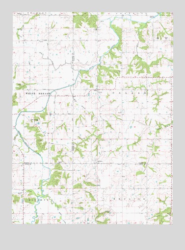
Newbern, IA USGS Topographic Map
Click on map above to begin viewing in our Map Viewer.

This topographic map contains these locations and features:
Feature Name Type Latitude Longitude GNIS ID View Map
Arian CemeteryCemeteryN41.2361°W93.2585°1975951View Map
Barker CreekStreamN41.1403°W93.3519°462012View Map
BauerPopulated PlaceN41.2039°W93.3072°454390View Map
Bauer CemeteryCemeteryN41.2033°W93.3080°1975952View Map
Bauer ParkParkN41.2014°W93.3155°1975670View Map
Bauer Post Office (historical)Post OfficeN41.2039°W93.3072°1975714View Map
Cochran CemeteryCemeteryN41.2072°W93.3672°1823402View Map
Cotton CreekStreamN41.1814°W93.3702°459080View Map
Dallas CemeteryCemeteryN41.2348°W93.2638°1823404View Map
Dallas Center SchoolSchoolN41.2050°W93.2699°455779View Map
Fairview CemeteryCemeteryN41.2338°W93.2557°1823405View Map
Fairview SchoolSchoolN41.1756°W93.2922°456521View Map
Flank CreekStreamN41.2317°W93.3608°456628View Map
Graves SchoolSchoolN41.1461°W93.3047°457081View Map
Hickory Grove CemeteryCemeteryN41.2394°W93.3674°1823408View Map
Horstman SchoolSchoolN41.2314°W93.3069°457671View Map
Kirk BranchStreamN41.2419°W93.2724°458106View Map
Lacona Community ParkParkN41.1847°W93.3544°1823399View Map
Little White Breast CreekStreamN41.1417°W93.3485°458531View Map
Marion SchoolSchoolN41.1756°W93.2530°458807View Map
New Chicago Post Office (historical)Post OfficeN41.2192°W93.3191°466588View Map
NewbernPopulated PlaceN41.1608°W93.3085°459501View Map
Newbern CemeteryCemeteryN41.1610°W93.3406°1823398View Map
Newbern Post Office (historical)Post OfficeN41.1608°W93.3085°1975713View Map
Pine Hill CemeteryCemeteryN41.1313°W93.2511°1823396View Map
Rosemont Post Office (historical)Post OfficeN41.2411°W93.3666°466583View Map
RosemountLocaleN41.2481°W93.3669°466031View Map
Rosemount CemeteryCemeteryN41.2484°W93.3679°1823410View Map
Saint Josephs ChurchChurchN41.2036°W93.3088°1823401View Map
Saint Marys ChurchChurchN41.2483°W93.3674°1823409View Map
Saint Paul CemeteryCemeteryN41.2397°W93.3085°1823407View Map
Saint Paul ChurchChurchN41.2331°W93.3088°1823406View Map
School Number 6SchoolN41.2036°W93.3452°465897View Map
Spring Hill CemeteryCemeteryN41.1322°W93.2989°1823397View Map
Stony CreekStreamN41.1794°W93.3683°462009View Map
Straham SchoolSchoolN41.1494°W93.3424°462023View Map
Tickel CemeteryCemeteryN41.2149°W93.2905°1823403View Map
Township of DallasCivilN41.2044°W93.2707°467676View Map
Willis CemeteryCemeteryN41.1893°W93.3466°1823400View Map
Winn BranchStreamN41.2061°W93.3283°463131View Map
Wolf CreekStreamN41.2147°W93.3213°463168View Map
Zion SchoolSchoolN41.1464°W93.2694°463281View Map

Note: Coordinates in the location and feature list above are referenced to NAD83 datum.


Copyright (C) 2008-2024 Ryan Niemi / Sunset Dynamics ... All Rights Reserved