TopoQuest Logo
Do you find TopoQuest useful?
Help keep TopoQuest running and adding new maps/features by donating!
Bitcoin:  19c7KJd3qBynnjoSw5npx9KScwjBe4ifkT
Litecoin:  LXs6TkuXGGXo1vDsWCkWVdjQX94eUKd6ui
Home View Maps Find Maps Find Places Resources & Links


Olmitz, Iowa Topographic Map

USGS Map Title: Olmitz, IA
USGS Map MRC: 41093A2
DRG (GeoTIFF) Download: o41093a2.tif


Neighboring USGS Topographic Map Quads:


  Newbern, IA  
41093B3
 

  Melcher-Dallas, IA  
41093B2
 

  Attica, IA  
41093B1
 

  Chariton, IA  
41093A3
 

  Olmitz, IA  
41093A2
 

  Weller, IA  
41093A1
 

  Corydon NE, IA  
40093H3
 

  Russell, IA  
40093H2
 

  Melrose, IA  
40093H1


Map MRC Location:

N42°
W94°
N42°
W93°
H8 H7 H6 H5 H4 H3 H2 H1
G8 G7 G6 G5 G4 G3 G2 G1
F8 F7 F6 F5 F4 F3 F2 F1
E8 E7 E6 E5 E4 E3 E2 E1
D8 D7 D6 D5 D4 D3 D2 D1
C8 C7 C6 C5 C4 C3 C2 C1
B8 B7 B6 B5 B4 B3 B2 B1
A8 A7 A6 A5 A4 A3 A2 A1
N41°
W94°
N41°
W93°

Olmitz, IA USGS 1:24K Topographic Map Preview:
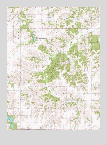
Olmitz, IA USGS Topographic Map
Click on map above to begin viewing in our Map Viewer.

This topographic map contains these locations and features:
Feature Name Type Latitude Longitude GNIS ID View Map
Beck AirportAirportN41.0004°W93.1558°2677141View Map
Belinda CemeteryCemeteryN41.1157°W93.1949°1823356View Map
Belinda SchoolSchoolN41.1136°W93.1927°454488View Map
Bethel CemeteryCemeteryN41.0440°W93.1593°1970658View Map
Bethel ChurchChurchN41.0442°W93.1588°1823352View Map
Cedar Grove Post Office (historical)Post OfficeN41.0528°W93.1335°1970597View Map
Cedar Grove SchoolSchoolN41.0439°W93.1741°455242View Map
Centennial SchoolSchoolN41.0889°W93.1930°455270View Map
Center SchoolSchoolN41.0361°W93.1349°455297View Map
Coal Glen ChurchChurchN41.1222°W93.1271°1823355View Map
Franklin SchoolSchoolN41.0433°W93.2299°456737View Map
Highland SchoolSchoolN41.0069°W93.2397°457479View Map
Irish Grove Post Office (historical)Post OfficeN41.0333°W93.1530°1970596View Map
Maceville Post Office (historical)Post OfficeN41.0592°W93.1585°1970595View Map
Ola Post Office (historical)Post OfficeN41.0528°W93.1433°1970594View Map
Old Ireland CemeteryCemeteryN41.0370°W93.1459°1823351View Map
OlmitzPopulated PlaceN41.0817°W93.1694°459860View Map
Olmitz (historical)LocaleN41.0817°W93.1694°1970592View Map
Olmitz Post Office (historical)Post OfficeN41.0817°W93.1694°1970593View Map
Oxford SchoolSchoolN41.0500°W93.2497°459979View Map
Pleasant TownhallBuildingN41.1142°W93.1941°463569View Map
Possum HollowValleyN41.0787°W93.1701°460372View Map
Prairie Hill SchoolSchoolN41.1172°W93.2294°460417View Map
Stephens State Forest - Cedar Creek UnitForestN41.0667°W93.1835°1970568View Map
Stephens State Forest - Chariton UnitForestN41.0639°W93.1669°1970567View Map
Sunnyside SchoolSchoolN41.0883°W93.2305°462100View Map
TipperaryPopulated PlaceN41.1136°W93.1544°462256View Map
Tipperary (historical)LocaleN41.1111°W93.1544°1970591View Map
Tipperary Post Office (historical)Post OfficeN41.1111°W93.1544°1970590View Map
Township of CedarCivilN41.0303°W93.1557°467557View Map
Township of PleasantCivilN41.1175°W93.1559°468530View Map
Victory SchoolSchoolN41.0008°W93.1549°462566View Map
West Alexander Post Office (historical)Post OfficeN41.0008°W93.2085°1970589View Map
Williamson Pond State Public Hunting and Recreation AreaParkN41.0925°W93.2127°1823354View Map
Zion CemeteryCemeteryN41.1118°W93.1673°1970656View Map
Zion CemeteryCemeteryN41.0962°W93.1673°1823353View Map
Zion SchoolSchoolN41.0881°W93.1555°463280View Map

Note: Coordinates in the location and feature list above are referenced to NAD83 datum.


Copyright (C) 2008-2025 Ryan Niemi / Sunset Dynamics ... All Rights Reserved