TopoQuest Logo
Do you find TopoQuest useful?
Help keep TopoQuest running and adding new maps/features by donating!
Bitcoin:  19c7KJd3qBynnjoSw5npx9KScwjBe4ifkT
Litecoin:  LXs6TkuXGGXo1vDsWCkWVdjQX94eUKd6ui
Home View Maps Find Maps Find Places Resources & Links


Newbury Neck, Maine Topographic Map

USGS Map Title: Newbury Neck, ME
USGS Map MRC: 44068D4
DRG (GeoTIFF) Download: o44068d4.tif


Neighboring USGS Topographic Map Quads:


  Branch Lake, ME  
44068E5
 

  Ellsworth, ME  
44068E4
 

  Hancock, ME  
44068E3
 

  Blue Hill, ME  
44068D5
 

  Newbury Neck, ME  
44068D4
 

  Salsbury Cove, ME  
44068D3
 

  Brooklin, ME  
44068C5
 

  Bartlett Island, ME  
44068C4
 

  Southwest Harbor, ME  
44068C3


Map MRC Location:

N45°
W69°
N45°
W68°
H8 H7 H6 H5 H4 H3 H2 H1
G8 G7 G6 G5 G4 G3 G2 G1
F8 F7 F6 F5 F4 F3 F2 F1
E8 E7 E6 E5 E4 E3 E2 E1
D8 D7 D6 D5 D4 D3 D2 D1
C8 C7 C6 C5 C4 C3 C2 C1
B8 B7 B6 B5 B4 B3 B2 B1
A8 A7 A6 A5 A4 A3 A2 A1
N44°
W69°
N44°
W68°

Newbury Neck, ME USGS 1:24K Topographic Map Preview:
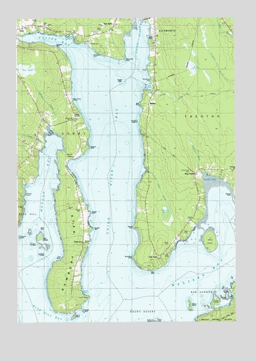
Newbury Neck, ME USGS Topographic Map
Click on map above to begin viewing in our Map Viewer.

This topographic map contains these locations and features:
Feature Name Type Latitude Longitude GNIS ID View Map
Alley CemeteryCemeteryN44.4120°W68.4039°580721View Map
Alley IslandIslandN44.4084°W68.3886°561205View Map
Anderson CemeteryCemeteryN44.4704°W68.4200°2730106View Map
BaysidePopulated PlaceN44.4640°W68.4236°579124View Map
Bayview CemeteryCemeteryN44.4080°W68.4619°561755View Map
Big HeathSwampN44.4809°W68.3964°562174View Map
Bird RockIslandN44.4076°W68.4925°562366View Map
Black IslandIslandN44.3823°W68.4006°562453View Map
Black RockBarN44.4140°W68.4870°580730View Map
Bluff PointCapeN44.4645°W68.4286°562620View Map
Browns PointCapeN44.4467°W68.4595°580736View Map
Burnt PointCapeN44.3945°W68.4681°580727View Map
Carrying PlaceBayN44.4465°W68.4742°563615View Map
Closson IslandIslandN44.4273°W68.4953°581375View Map
Closson PointCapeN44.4276°W68.4956°564111View Map
Conary NubIslandN44.4101°W68.4992°564277View Map
Contention CoveBayN44.4920°W68.4670°564302View Map
Curtis CoveBayN44.3879°W68.4631°564684View Map
East SurryPopulated PlaceN44.4970°W68.4434°565693View Map
Emerton BrookStreamN44.4562°W68.4811°580056View Map
Goose CoveBayN44.4326°W68.3861°580776View Map
Goose Cove CemeteryCemeteryN44.4367°W68.4011°580737View Map
Goose RockIslandN44.3798°W68.4625°566942View Map
Grant RockBarN44.4181°W68.4325°580734View Map
Gray CemeteryCemeteryN44.4028°W68.4145°580725View Map
Green IslandIslandN44.3834°W68.3864°567229View Map
Haskell CemeteryCemeteryN44.4212°W68.4636°580729View Map
Haskell PointCapeN44.4206°W68.4595°567736View Map
Haynes CemeteryCemeteryN44.4165°W68.4003°567826View Map
Haynes Gilley Jordan CemeteryCemeteryN44.4382°W68.4248°2736651View Map
Haynes HeathSwampN44.4192°W68.4142°580733View Map
Haynes PointCapeN44.4137°W68.4317°567828View Map
Heath BrookStreamN44.4373°W68.4256°567874View Map
High HeadCapeN44.3849°W68.4617°568018View Map
Hopkins PointCapeN44.4134°W68.4578°568256View Map
Jed IslandIslandN44.4098°W68.4875°568783View Map
Loids BrookStreamN44.4695°W68.4220°570160View Map
Long CoveBayN44.3987°W68.3811°580728View Map
Lord RockBarN44.4720°W68.4300°580055View Map
McFarland BrookStreamN44.4365°W68.3939°580732View Map
Mill CoveBayN44.4712°W68.4225°571325View Map
Milliken IslandIslandN44.3845°W68.3797°580723View Map
Moore CemeteryCemeteryN44.4528°W68.4278°580735View Map
Morgan BayBayN44.4412°W68.4814°571661View Map
Morgan Bay CemeteryCemeteryN44.4577°W68.4695°580740View Map
Murch CemeteryCemeteryN44.4073°W68.4134°580720View Map
Newbury NeckCapeN44.4065°W68.4706°572134View Map
Oak PointCapeN44.3970°W68.4239°572629View Map
Oak Point CemeteriesCemeteryN44.4016°W68.4194°2736684View Map
Oak Point CemeteriesCemeteryN44.3979°W68.4248°2736685View Map
Patten BayBayN44.4901°W68.4806°573064View Map
Poignant PointCapeN44.4884°W68.4772°580054View Map
Richs CornerPopulated PlaceN44.4595°W68.4661°580739View Map
Seal LedgeBarN44.4123°W68.4928°580731View Map
Smelt BrookStreamN44.4487°W68.4850°575586View Map
Smiths LedgeBarN44.4584°W68.4314°581384View Map
South LedgeBarN44.4031°W68.4872°580726View Map
South SurryPopulated PlaceN44.4126°W68.4622°579726View Map
South Surry CemeteryCemeteryN44.4579°W68.4675°575910View Map
Southwest PointCapeN44.4009°W68.4334°575957View Map
Surry Post OfficePost OfficeN44.4967°W68.4950°1911995View Map
The Gatherings CampgroundLocaleN44.4895°W68.4578°1912008View Map
The HeathSwampN44.4631°W68.4959°580045View Map
The LedgeBarN44.3862°W68.3800°580724View Map
The NookBayN44.4034°W68.4731°576871View Map
The ReefBarN44.3809°W68.3911°1911878View Map
Town of TrentonCivilN44.4431°W68.3997°582768View Map
Tupper LedgeBarN44.4737°W68.4389°580699View Map
Union RiverStreamN44.4787°W68.4331°577553View Map
Union River BayBayN44.4387°W68.4453°577554View Map
Village CemeteryCemeteryN44.4970°W68.4834°580053View Map
Vokes Driving RangeLocaleN44.4990°W68.3811°1912055View Map
WDEA-AM (Ellsworth)TowerN44.4667°W68.4692°582014View Map
Webber CoveBayN44.4304°W68.4967°577933View Map
West TrentonPopulated PlaceN44.4356°W68.3970°578233View Map
Western BayBayN44.3895°W68.4014°580012View Map
Weymouth PointCapeN44.4840°W68.4381°578283View Map
Whittenmore CemeteryCemeteryN44.4740°W68.4214°578435View Map

Note: Coordinates in the location and feature list above are referenced to NAD83 datum.


Copyright (C) 2008-2025 Ryan Niemi / Sunset Dynamics ... All Rights Reserved