TopoQuest Logo
Do you find TopoQuest useful?
Help keep TopoQuest running and adding new maps/features by donating!
Bitcoin:  19c7KJd3qBynnjoSw5npx9KScwjBe4ifkT
Litecoin:  LXs6TkuXGGXo1vDsWCkWVdjQX94eUKd6ui
Home View Maps Find Maps Find Places Resources & Links


Brooklin, Maine Topographic Map

USGS Map Title: Brooklin, ME
USGS Map MRC: 44068C5
DRG (GeoTIFF) Download: o44068c5.tif


Neighboring USGS Topographic Map Quads:


  Penobscot, ME  
44068D6
 

  Blue Hill, ME  
44068D5
 

  Newbury Neck, ME  
44068D4
 

  Sargentville, ME  
44068C6
 

  Brooklin, ME  
44068C5
 

  Bartlett Island, ME  
44068C4
 

  Deer Isle, ME  
44068B6
 

  Stinson Neck, ME  
44068B5
 

  Swans Island, ME  
44068B4


Map MRC Location:

N45°
W69°
N45°
W68°
H8 H7 H6 H5 H4 H3 H2 H1
G8 G7 G6 G5 G4 G3 G2 G1
F8 F7 F6 F5 F4 F3 F2 F1
E8 E7 E6 E5 E4 E3 E2 E1
D8 D7 D6 D5 D4 D3 D2 D1
C8 C7 C6 C5 C4 C3 C2 C1
B8 B7 B6 B5 B4 B3 B2 B1
A8 A7 A6 A5 A4 A3 A2 A1
N44°
W69°
N44°
W68°

Brooklin, ME USGS 1:24K Topographic Map Preview:
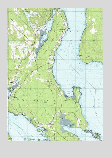
Brooklin, ME USGS Topographic Map
Click on map above to begin viewing in our Map Viewer.

This topographic map contains these locations and features:
Feature Name Type Latitude Longitude GNIS ID View Map
Allen CoveBayN44.2920°W68.5436°561182View Map
Allen PointCapeN44.3540°W68.5756°580203View Map
Batchelder BrookStreamN44.2723°W68.5578°580186View Map
Bayberry PointCapeN44.2706°W68.5945°580184View Map
Benjamin River MarineLocaleN44.2956°W68.6189°1911407View Map
Birchhead ShoreBeachN44.3070°W68.5620°580694View Map
Black CoveBayN44.2654°W68.5397°580181View Map
Black PointCapeN44.2631°W68.5389°580182View Map
Black SwampSwampN44.2984°W68.5870°580195View Map
Blue Hill BayBayN44.3026°W68.5100°562594View Map
Blue Hill NeckCapeN44.3551°W68.5581°562598View Map
Bridges PointCapeN44.2751°W68.6147°580188View Map
BrooklinPopulated PlaceN44.2662°W68.5692°563011View Map
Brooklin Post OfficePost OfficeN44.2656°W68.5714°1911435View Map
Brooklin SchoolSchoolN44.2692°W68.5704°1911436View Map
Brooklin Volunteer Fire DepartmentBuildingN44.2670°W68.5666°2552767View Map
Cape CarterCapeN44.2804°W68.6245°563465View Map
Carleton BrookStreamN44.3012°W68.6120°580199View Map
Carleton IslandIslandN44.3512°W68.5736°563546View Map
Center HarborBayN44.2606°W68.5767°563749View Map
Center Harbor Yacht ClubLocaleN44.2626°W68.5797°1911475View Map
Chatto IslandIslandN44.2601°W68.5842°563900View Map
Clapps MeadowSwampN44.3376°W68.6009°580205View Map
Closson CoveBayN44.3234°W68.5022°564109View Map
Deep CoveBayN44.3592°W68.5195°564951View Map
Dodges MeadowSwampN44.2862°W68.5786°580193View Map
Duck MarshSwampN44.3698°W68.5895°580211View Map
Duffy CoveBayN44.3242°W68.5131°565388View Map
Duffy PointCapeN44.3237°W68.5214°565389View Map
Eaton BrookStreamN44.2762°W68.6050°580187View Map
First Baptist ChurchChurchN44.3045°W68.6142°1911599View Map
First PondLakeN44.3602°W68.5954°566186View Map
Flye IslandIslandN44.2540°W68.5078°566326View Map
Flye PointCapeN44.2679°W68.5320°581417View Map
Flye Point LedgeBenchN44.2584°W68.5161°578918View Map
Freethy BrookStreamN44.2681°W68.5914°580686View Map
Freethy CemeteryCemeteryN44.2542°W68.5420°580183View Map
Friend Memorial Public LibraryBuildingN44.2663°W68.5695°1911624View Map
Frost Pond BogSwampN44.3417°W68.6134°580204View Map
Gander IslandIslandN44.2562°W68.5106°566676View Map
Goose IslandIslandN44.2556°W68.5056°566916View Map
Great HeathSwampN44.2895°W68.6111°580191View Map
Great MeadowSwampN44.3256°W68.5922°567160View Map
Harriman LedgeBarN44.3006°W68.5236°581377View Map
Harriman PointCapeN44.2995°W68.5334°567971View Map
HavenPopulated PlaceN44.2665°W68.5864°567769View Map
Herrick BayBayN44.2604°W68.5381°567965View Map
Herricks LedgesBarN44.2559°W68.5800°580180View Map
High HeadCapeN44.3423°W68.5545°568013View Map
High HeadCapeN44.2545°W68.5744°568015View Map
Jims PointCapeN44.3304°W68.5309°568834View Map
Joes IslandIslandN44.2512°W68.5739°580178View Map
Little HeathSwampN44.2931°W68.6036°580189View Map
Lone CoveBayN44.3606°W68.5728°580206View Map
Long IslandIslandN44.3423°W68.5014°579985View Map
Long Island CemeteryCemeteryN44.3281°W68.5206°1911742View Map
Long SwampSwampN44.2862°W68.5867°580192View Map
Meadow BrookStreamN44.3095°W68.6081°580198View Map
Means PointCapeN44.2987°W68.6228°580190View Map
Meating House PointCapeN44.3376°W68.5814°580200View Map
Mother Bush BrookStreamN44.3679°W68.5653°580888View Map
Mount Ephraim CemeteryCemeteryN44.3015°W68.5714°580196View Map
North BrooklinPopulated PlaceN44.3054°W68.5700°572311View Map
North SedgwickPopulated PlaceN44.3406°W68.5889°572409View Map
Northwest CoveBayN44.2506°W68.5742°572470View Map
Old Birchland CemeteryCemeteryN44.3178°W68.5689°580202View Map
Owls HeadCapeN44.3573°W68.5934°580207View Map
Peninsula Montessori SchoolSchoolN44.3538°W68.6106°2738162View Map
Pine Grove CemeteryCemeteryN44.3497°W68.5884°573359View Map
Reach CemeteryCemeteryN44.2520°W68.6236°580176View Map
Ridge Road Burying GroundCemeteryN44.3623°W68.6224°2736323View Map
Rockbound ChapelChurchN44.2887°W68.6189°574357View Map
Rural CemeteryCemeteryN44.3153°W68.6086°574594View Map
Salt Camp CoveBayN44.3359°W68.5289°574789View Map
Salt PondLakeN44.3472°W68.5744°574793View Map
Sand PointCapeN44.3562°W68.5450°574848View Map
SedgwickPopulated PlaceN44.3037°W68.6161°575222View Map
Sedgwick Library AssociationBuildingN44.3036°W68.6164°2738399View Map
Sedgwick Post OfficePost OfficeN44.3039°W68.6213°1911932View Map
Sedgwick Volunteer Fire Department Ridge Road StationBuildingN44.3499°W68.6042°2552765View Map
Sibley PondLakeN44.3437°W68.5129°575447View Map
South Blue HillPopulated PlaceN44.3540°W68.5486°575759View Map
Southren CoveBayN44.2567°W68.5772°580179View Map
Stills PointCapeN44.3723°W68.5509°563645View Map
Thurston BrookStreamN44.3265°W68.5922°580201View Map
Torrey CastleIslandN44.2515°W68.6020°577204View Map
Torrey IslandsIslandN44.2512°W68.5911°578940View Map
Torrey LedgeBarN44.2545°W68.6025°578882View Map
Town of BrooklinCivilN44.2684°W68.5535°582370View Map
Upper Torrey IslandIslandN44.2509°W68.5945°577206View Map
Watson BrookStreamN44.2765°W68.5542°580194View Map
Wells CoveBayN44.2690°W68.5934°580185View Map
West BrooklinPopulated PlaceN44.2920°W68.6159°578110View Map

Note: Coordinates in the location and feature list above are referenced to NAD83 datum.


Copyright (C) 2008-2024 Ryan Niemi / Sunset Dynamics ... All Rights Reserved