TopoQuest Logo
Do you find TopoQuest useful?
Help keep TopoQuest running and adding new maps/features by donating!
Bitcoin:  19c7KJd3qBynnjoSw5npx9KScwjBe4ifkT
Litecoin:  LXs6TkuXGGXo1vDsWCkWVdjQX94eUKd6ui
Home View Maps Find Maps Find Places Resources & Links


Salsbury Cove, Maine Topographic Map

USGS Map Title: Salsbury Cove, ME
USGS Map MRC: 44068D3
DRG (GeoTIFF) Download: o44068d3.tif


Neighboring USGS Topographic Map Quads:


  Ellsworth, ME  
44068E4
 

  Hancock, ME  
44068E3
 

  Sullivan, ME  
44068E2
 

  Newbury Neck, ME  
44068D4
 

  Salsbury Cove, ME  
44068D3
 

  Bar Harbor, ME  
44068D2
 

  Bartlett Island, ME  
44068C4
 

  Southwest Harbor, ME  
44068C3
 

  Seal Harbor, ME  
44068C2


Map MRC Location:

N45°
W69°
N45°
W68°
H8 H7 H6 H5 H4 H3 H2 H1
G8 G7 G6 G5 G4 G3 G2 G1
F8 F7 F6 F5 F4 F3 F2 F1
E8 E7 E6 E5 E4 E3 E2 E1
D8 D7 D6 D5 D4 D3 D2 D1
C8 C7 C6 C5 C4 C3 C2 C1
B8 B7 B6 B5 B4 B3 B2 B1
A8 A7 A6 A5 A4 A3 A2 A1
N44°
W69°
N44°
W68°

Salsbury Cove, ME USGS 1:24K Topographic Map Preview:
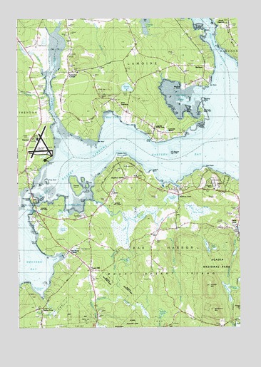
Salsbury Cove, ME USGS Topographic Map
Click on map above to begin viewing in our Map Viewer.

This topographic map contains these locations and features:
Feature Name Type Latitude Longitude GNIS ID View Map
Acadia Information CenterBuildingN44.4351°W68.3692°1911325View Map
Acadia ZooParkN44.4865°W68.3678°1912120View Map
Aunt Betseys BrookStreamN44.4184°W68.3125°561353View Map
Bar Harbor Ambulance Town Hill StationBuildingN44.3981°W68.3347°2553044View Map
Bar Harbor CampgroundLocaleN44.4345°W68.2653°1911364View Map
Bar Harbor Fire Department Town Hill StationBuildingN44.3982°W68.3346°1912020View Map
Bar Harbor Golf CourseLocaleN44.4890°W68.3606°1911368View Map
Barcadia Camping ResortLocaleN44.4376°W68.3653°1911379View Map
Beaver PondsLakeN44.3940°W68.2504°1911397View Map
Berry CoveBayN44.4604°W68.3211°562081View Map
Blagden PreserveParkN44.3870°W68.3720°1911417View Map
Blunts PointCapeN44.4254°W68.3350°562627View Map
Blunts PondLakeN44.4720°W68.3130°562628View Map
Breakneck BrookStreamN44.4137°W68.2500°562925View Map
Breakneck PondsLakeN44.3895°W68.2569°562928View Map
Burns Richardson Burial GroundCemeteryN44.3897°W68.3600°2730125View Map
Church of Our Father Episcopal ChurchChurchN44.4206°W68.2503°1911483View Map
Clark CoveBayN44.4029°W68.3509°564033View Map
Crippens BrookStreamN44.4687°W68.3575°581403View Map
East LamoinePopulated PlaceN44.4648°W68.3164°565628View Map
East Lamoine CemeteryCemeteryN44.4687°W68.3203°1911553View Map
Eastern BayBayN44.4420°W68.2820°565708View Map
EdenPopulated PlaceN44.4309°W68.3209°565781View Map
Eden Baptist ChurchChurchN44.4309°W68.2883°1911565View Map
Emery CemeteryCemeteryN44.4133°W68.2976°2736638View Map
Emery CoveBayN44.4337°W68.2931°565904View Map
Emery Family Burial GroundCemeteryN44.4308°W68.2860°2736639View Map
Eno PinesWoodsN44.4195°W68.2850°1911591View Map
Fawn PondLakeN44.4066°W68.2641°566082View Map
Federated ChurchChurchN44.3990°W68.3320°566088View Map
Forest Hill CemeteryCemeteryN44.4792°W68.3434°580851View Map
Fosters BrookStreamN44.4798°W68.3589°581420View Map
Fosters PondReservoirN44.4864°W68.3667°1774578View Map
Fosters Pond DamDamN44.4860°W68.3696°1774577View Map
Fountain of Life Foursquare ChurchChurchN44.4304°W68.2911°1911612View Map
French Hill BrookStreamN44.4100°W68.3126°2071306View Map
French Hill PondLakeN44.4020°W68.3130°1955636View Map
Frenchmans HillSummitN44.3965°W68.3061°1988306View Map
Fresh MeadowSwampN44.4209°W68.3136°566584View Map
Googins LedgeBarN44.4456°W68.2878°581428View Map
Hadley CemeteryCemeteryN44.4048°W68.3434°2736646View Map
Hadley PointCapeN44.4431°W68.3178°567420View Map
Hadley Point CemeteryCemeteryN44.4391°W68.3167°2736647View Map
Hadleys Point CampgroundLocaleN44.4404°W68.3314°1911656View Map
Hamilton PondReservoirN44.4272°W68.2886°580850View Map
Hamilton Pond DamDamN44.4251°W68.2911°1774587View Map
Hamilton StationLocaleN44.4354°W68.3133°567531View Map
Hamilton Station CemeteryCemeteryN44.4363°W68.3069°2736648View Map
Hancock County-Bar Harbor AirportAirportN44.4462°W68.3625°580849View Map
Haynes PointCapeN44.4251°W68.3725°567829View Map
Higgins CemeteryCemeteryN44.3828°W68.3609°1911685View Map
Higgins Marcyes Burial GroundCemeteryN44.3962°W68.3424°2736653View Map
Hillside CemeteryCemeteryN44.4231°W68.2517°568074View Map
Hulls CovePopulated PlaceN44.4192°W68.2506°568447View Map
Hulls Cove Post OfficePost OfficeN44.4128°W68.2513°1911690View Map
Indian PointCapeN44.3923°W68.3692°568593View Map
Indian PointPopulated PlaceN44.3829°W68.3603°568596View Map
Ireson HillSummitN44.4319°W68.2631°568667View Map
Israel PointCapeN44.4273°W68.3492°568712View Map
Jones MarshSwampN44.4151°W68.3500°568966View Map
Jordan RiverStreamN44.4442°W68.3431°568997View Map
Kitteredge BrookStreamN44.3759°W68.3297°569228View Map
Lake WoodLakeN44.4076°W68.2683°578657View Map
Lamoine Baptist ChurchChurchN44.4787°W68.3442°1911726View Map
Lamoine BeachPopulated PlaceN44.4506°W68.2922°569349View Map
Lamoine BeachBeachN44.4515°W68.2856°1911727View Map
Lamoine Beach MarinaLocaleN44.4534°W68.2803°1911728View Map
Lamoine Consolidated SchoolSchoolN44.4785°W68.3410°1911730View Map
Lamoine CornerPopulated PlaceN44.4779°W68.3453°569348View Map
Lamoine State ParkParkN44.4549°W68.3006°569350View Map
Lamoine Volunteer Fire DepartmentBuildingN44.4786°W68.3416°2553215View Map
Leland CemeteryCemeteryN44.4526°W68.3688°569474View Map
Leland CemeteryCemeteryN44.4352°W68.2986°2736670View Map
Leland PointCapeN44.4373°W68.2992°569475View Map
Long HeathSwampN44.3842°W68.3056°570207View Map
MarlboroPopulated PlaceN44.4756°W68.2700°570789View Map
Marlboro BeachBeachN44.4729°W68.2725°570790View Map
McFarland Hill TrailTrailN44.3820°W68.2650°1911759View Map
McFarland MountainSummitN44.3822°W68.2651°570976View Map
Meadow PointCapeN44.4612°W68.2700°571097View Map
Mosely PointCapeN44.4942°W68.2683°571715View Map
Mount Desert Island Camping ResortLocaleN44.4201°W68.3389°1912122View Map
Mount Desert Island LaboratoryBuildingN44.4317°W68.2617°1912121View Map
Mount Desert NarrowsChannelN44.4415°W68.3370°571763View Map
Mountain View CemeteryCemeteryN44.3955°W68.3332°571815View Map
Narrows Too Camping ResortLocaleN44.4401°W68.3647°1911795View Map
Naval Auxiliary Air Station Bar Harbor (historical)MilitaryN44.4489°W68.3614°2571502View Map
Negro PointCapeN44.4065°W68.3597°572089View Map
Newman GraveCemeteryN44.3850°W68.2650°2736681View Map
Northeast CreekStreamN44.4259°W68.3303°572440View Map
Northwest CoveBayN44.3923°W68.3617°572471View Map
Oceanarium Bar HarborLocaleN44.4242°W68.3642°1912123View Map
Old County Road CemeteryCemeteryN44.4185°W68.3650°2736689View Map
Old Mill BrookStreamN44.4217°W68.3011°572715View Map
Old PointCapeN44.4506°W68.3297°572719View Map
Old PointCapeN44.4742°W68.2661°572720View Map
Oldhouse CoveBayN44.4217°W68.3656°572739View Map
Paine CemeteryCemeteryN44.4095°W68.2972°1911847View Map
Patty Lot HillSummitN44.3768°W68.3361°573076View Map
Peach CemeteryCemeteryN44.3989°W68.2949°2736692View Map
Pecks PointCapeN44.4881°W68.2603°580852View Map
Prays BrookStreamN44.3862°W68.3597°573767View Map
Raccoon CoveBayN44.4667°W68.2783°573954View Map
Red Rock CornerPopulated PlaceN44.4056°W68.3453°574099View Map
Salisbury CemeteryCemeteryN44.4314°W68.2801°1911898View Map
Salsbury CoveBayN44.4326°W68.2872°574786View Map
Salsbury CovePopulated PlaceN44.4306°W68.2836°574787View Map
Salsbury Cove Post Office (historical)Post OfficeN44.4304°W68.2845°1911899View Map
Salt PondBayN44.4206°W68.3461°574792View Map
Sand PointCapeN44.4387°W68.2683°574849View Map
Shooting LedgeBarN44.4667°W68.2675°580848View Map
Skillings RiverStreamN44.4729°W68.2550°575522View Map
Spruce PointCapeN44.4145°W68.3650°1911975View Map
Spruce Valley CampgroundLocaleN44.4070°W68.3392°1911976View Map
Stony BrookStreamN44.4212°W68.2970°576394View Map
Sunken HeathSwampN44.3812°W68.2928°576535View Map
The HeathSwampN44.4215°W68.2742°576819View Map
The OvensBarN44.4379°W68.2645°576882View Map
The TwinniesIslandN44.4348°W68.3372°576939View Map
Thomas BayBayN44.4251°W68.3420°576980View Map
Thomas CemeteryCemeteryN44.4295°W68.3245°2736340View Map
Thomas IslandIslandN44.4323°W68.3422°576988View Map
Thompson IslandIslandN44.4270°W68.3639°577014View Map
Thompson Island Information CenterBuildingN44.4265°W68.3656°1912012View Map
Timber PointCapeN44.4612°W68.2795°577119View Map
Town HillPopulated PlaceN44.3987°W68.3336°577230View Map
Town Hill Federated ChurchChurchN44.3987°W68.3328°1912019View Map
Town of Bar HarborCivilN44.3856°W68.2658°582341View Map
Town of LamoineCivilN44.4840°W68.3144°582549View Map
Trap RockIslandN44.4351°W68.3572°577277View Map
TrentonPopulated PlaceN44.4390°W68.3700°577302View Map
Trenton Baptist ChurchChurchN44.4520°W68.3670°1912026View Map
Trenton BridgeBridgeN44.4300°W68.3675°577303View Map
Trenton BridgeBridgeN44.4301°W68.3672°1912027View Map
Trenton Business ParkLocaleN44.4490°W68.3700°1912028View Map
Trenton Elementary SchoolSchoolN44.4543°W68.3687°1912029View Map
Trenton SchoolSchoolN44.4376°W68.3745°570977View Map
Trenton Town OfficesBuildingN44.4381°W68.3720°1912031View Map
Trenton Volunteer Fire DepartmentBuildingN44.4378°W68.3747°2552757View Map
West Eden Schoolhouse (historical)SchoolN44.3984°W68.3347°1912068View Map
Woodland Park CampgroundLocaleN44.4320°W68.2972°1912106View Map
Youngs MountainSummitN44.3920°W68.2673°578804View Map

Note: Coordinates in the location and feature list above are referenced to NAD83 datum.


Copyright (C) 2008-2024 Ryan Niemi / Sunset Dynamics ... All Rights Reserved