TopoQuest Logo
Do you find TopoQuest useful?
Help keep TopoQuest running and adding new maps/features by donating!
Bitcoin:  19c7KJd3qBynnjoSw5npx9KScwjBe4ifkT
Litecoin:  LXs6TkuXGGXo1vDsWCkWVdjQX94eUKd6ui
Home View Maps Find Maps Find Places Resources & Links


Patterson, California Topographic Map

USGS Map Title: Patterson, CA
USGS Map MRC: 37121D2
DRG (GeoTIFF) Download: o37121d2.tif


Neighboring USGS Topographic Map Quads:


  Solyo, CA  
37121E3
 

  Westley, CA  
37121E2
 

  Brush Lake, CA  
37121E1
 

  Copper Mountain, CA  
37121D3
 

  Patterson, CA  
37121D2
 

  Crows Landing, CA  
37121D1
 

  Wilcox Ridge, CA  
37121C3
 

  Orestimba Peak, CA  
37121C2
 

  Newman, CA  
37121C1


Map MRC Location:

N38°
W122°
N38°
W121°
H8 H7 H6 H5 H4 H3 H2 H1
G8 G7 G6 G5 G4 G3 G2 G1
F8 F7 F6 F5 F4 F3 F2 F1
E8 E7 E6 E5 E4 E3 E2 E1
D8 D7 D6 D5 D4 D3 D2 D1
C8 C7 C6 C5 C4 C3 C2 C1
B8 B7 B6 B5 B4 B3 B2 B1
A8 A7 A6 A5 A4 A3 A2 A1
N37°
W122°
N37°
W121°

Patterson, CA USGS 1:24K Topographic Map Preview:
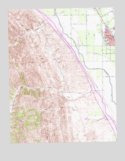
Patterson, CA USGS Topographic Map
Click on map above to begin viewing in our Map Viewer.

This topographic map contains these locations and features:
Feature Name Type Latitude Longitude GNIS ID View Map
Beltran FarmsLocaleN37.3800°W121.1317°2708487View Map
Black GulchValleyN37.4647°W121.1794°219361View Map
City of PattersonCivilN37.4738°W121.1437°2411383View Map
Del Puerto CanyonValleyN37.4883°W121.2069°222236View Map
Del Puerto Fire Control StationLocaleN37.4799°W121.2247°222238View Map
Del Puerto Health Care District Patterson AmbulanceBuildingN37.4663°W121.1354°2662237View Map
Del Puerto High SchoolSchoolN37.4757°W121.1402°1817207View Map
Del Puerto HospitalHospitalN37.4669°W121.1349°1658398View Map
Department of Forestry and Fire Protection Station 15 Del PuertoBuildingN37.4640°W121.1626°2624694View Map
Evangelical Covenant ChurchChurchN37.4702°W121.1327°1817208View Map
Federated Methodist-Presbyterian ChurchChurchN37.4708°W121.1324°1817210View Map
Felipe Garza ParkParkN37.4785°W121.1266°1817211View Map
Fink Road LandfillLocaleN37.3894°W121.1372°2726489View Map
First Assembly of God ChurchChurchN37.4691°W121.1327°1817212View Map
First Baptist ChurchChurchN37.4685°W121.1305°1817214View Map
First LiftCanalN37.4608°W121.1330°223520View Map
Haight School (historical)SchoolN37.4988°W121.1766°1703092View Map
Las Palmas Elementary SchoolSchoolN37.4690°W121.1344°226895View Map
Lateral Five SouthCanalN37.4808°W121.1585°254874View Map
Lateral Four NorthCanalN37.4869°W121.1352°255092View Map
Lateral MCanalN37.4858°W121.1441°254889View Map
Lateral Six SouthCanalN37.4863°W121.1763°254876View Map
Lateral Three NorthCanalN37.4977°W121.1272°254870View Map
North ParkParkN37.4727°W121.1297°1817225View Map
Northmead Elementary SchoolSchoolN37.4758°W121.1387°229741View Map
Our Saviours Lutheran ChurchChurchN37.4699°W121.1341°1817238View Map
PattersonPopulated PlaceN37.4716°W121.1297°277574View Map
Patterson Airport (historical)AirportN37.4653°W121.1700°1653813View Map
Patterson Branch Stanislaus County Free LibraryBuildingN37.4719°W121.1316°1817239View Map
Patterson City HallBuildingN37.4708°W121.1313°1817240View Map
Patterson Community StadiumParkN37.4733°W121.1399°1817241View Map
Patterson High SchoolSchoolN37.4712°W121.1376°1817242View Map
Patterson Junior High SchoolSchoolN37.4708°W121.1372°1817243View Map
Patterson Police DepartmentBuildingN37.4705°W121.1306°2755682View Map
Patterson Post OfficePost OfficeN37.4717°W121.1320°1817244View Map
Sacred Heart Catholic ChurchChurchN37.4727°W121.1349°1817247View Map
Sacred Heart Catholic SchoolSchoolN37.4778°W121.1386°1817248View Map
Salado SubstationLocaleN37.4222°W121.1474°1654409View Map
Second LiftCanalN37.4535°W121.1360°232773View Map
South ParkParkN37.4716°W121.1291°1817254View Map
The Center BuildingBuildingN37.4716°W121.1302°1817255View Map
Vanormer (historical)Populated PlaceN37.4985°W121.1472°1703093View Map
Vanormer Pumping StationLocaleN37.4991°W121.1485°1654505View Map
West Stanislaus County Fire Protection District HeadquartersBuildingN37.4706°W121.1316°2623743View Map
West Stanislaus County Fire Protection District Patterson Station 2BuildingN37.4755°W121.1640°2624374View Map
West Stanislaus Fire Protection District Patterson Station 1BuildingN37.4706°W121.1315°2624268View Map

Note: Coordinates in the location and feature list above are referenced to NAD83 datum.


Copyright (C) 2008-2025 Ryan Niemi / Sunset Dynamics ... All Rights Reserved