TopoQuest Logo
Do you find TopoQuest useful?
Help keep TopoQuest running and adding new maps/features by donating!
Bitcoin:  19c7KJd3qBynnjoSw5npx9KScwjBe4ifkT
Litecoin:  LXs6TkuXGGXo1vDsWCkWVdjQX94eUKd6ui
Home View Maps Find Maps Find Places Resources & Links


Newton, Illinois Topographic Map

USGS Map Title: Newton, IL
USGS Map MRC: 38088H2
DRG (GeoTIFF) Download: o38088h2.tif


Neighboring USGS Topographic Map Quads:


  Wheeler, IL  
39088A3
 

  Rose Hill, IL  
39088A2
 

  Yale, IL  
39088A1
 

  Latona, IL  
38088H3
 

  Newton, IL  
38088H2
 

  Sainte Marie, IL  
38088H1
 

  Sailor Springs, IL  
38088G3
 

  Wakefield, IL  
38088G2
 

  Dundas, IL  
38088G1


Map MRC Location:

N39°
W89°
N39°
W88°
H8 H7 H6 H5 H4 H3 H2 H1
G8 G7 G6 G5 G4 G3 G2 G1
F8 F7 F6 F5 F4 F3 F2 F1
E8 E7 E6 E5 E4 E3 E2 E1
D8 D7 D6 D5 D4 D3 D2 D1
C8 C7 C6 C5 C4 C3 C2 C1
B8 B7 B6 B5 B4 B3 B2 B1
A8 A7 A6 A5 A4 A3 A2 A1
N38°
W89°
N38°
W88°

Newton, IL USGS 1:24K Topographic Map Preview:
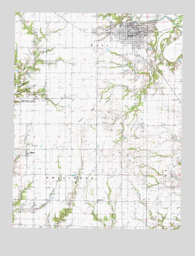
Newton, IL USGS Topographic Map
Click on map above to begin viewing in our Map Viewer.

This topographic map contains these locations and features:
Feature Name Type Latitude Longitude GNIS ID View Map
BogotaPopulated PlaceN38.9184°W88.2400°404648View Map
Bogota Post OfficePost OfficeN38.9178°W88.2398°1815643View Map
Buck Grove School (historical)SchoolN38.9289°W88.1706°405098View Map
Bunker Grove School (historical)SchoolN38.9795°W88.2259°405194View Map
Calvin School (historical)SchoolN38.8925°W88.2431°405414View Map
Center School (historical)SchoolN38.8920°W88.2053°405799View Map
City of NewtonCivilN38.9882°W88.1648°2395228View Map
Cummins CemeteryCemeteryN38.9361°W88.1878°1923101View Map
Eaton FarmsLocaleN38.9625°W88.1614°2724428View Map
First Baptist ChurchChurchN38.9895°W88.1653°2055245View Map
Greenwood School (historical)SchoolN38.8923°W88.1323°409467View Map
Happy Hollow School (historical)SchoolN38.9495°W88.2456°409763View Map
Honey CemeteryCemeteryN38.9236°W88.2392°1923120View Map
Jasper County Ambulance ServiceBuildingN38.9905°W88.1634°2673839View Map
Jasper County Flying Club AirportAirportN38.9339°W88.1561°427612View Map
Jasper County Safety Council HeliportAirportN38.9895°W88.1764°427613View Map
Jasper County Sheriff's OfficeBuildingN38.9918°W88.1609°2758966View Map
Long Branch School (historical)SchoolN38.9492°W88.2237°412555View Map
M and P FarmLocaleN38.9453°W88.2086°2724436View Map
Maple Hill FarmLocaleN38.8839°W88.2356°2724433View Map
Moulden School (historical)SchoolN38.9648°W88.1748°413897View Map
New Life Christian CenterChurchN38.9912°W88.1700°2055248View Map
NewtonPopulated PlaceN38.9909°W88.1625°414496View Map
Newton Community High SchoolSchoolN38.9898°W88.1750°1815652View Map
Newton Elementary SchoolSchoolN38.9867°W88.1603°1815653View Map
Newton Police DepartmentBuildingN38.9916°W88.1609°2759094View Map
Newton Post OfficePost OfficeN38.9911°W88.1629°1725225View Map
Newton Water Treatment PlantLocaleN38.9939°W88.1608°2740884View Map
Pleasant RidgeRidgeN38.9398°W88.1950°415879View Map
Pleasant Ridge CemeteryCemeteryN38.9328°W88.2075°1923574View Map
Pleasant Ridge School (historical)SchoolN38.9214°W88.2078°415888View Map
Riverside CemeteryCemeteryN38.9934°W88.1550°1923575View Map
Saint Thomas ChurchChurchN38.9906°W88.1653°2055249View Map
Saint Thomas SchoolSchoolN38.9906°W88.1648°2055251View Map
Schafer FarmsLocaleN38.9639°W88.2086°2724505View Map
Scott Avenue Christian ChurchChurchN38.9864°W88.1506°2055250View Map
ShamrockPopulated PlaceN38.8909°W88.1873°1725231View Map
Smithenry FarmsLocaleN38.9522°W88.1328°2724523View Map
Township of SmallwoodCivilN38.8988°W88.2049°429755View Map
Vanderhoof CemeteryCemeteryN38.9664°W88.1328°1923587View Map
Vanderhoof School (historical)SchoolN38.9620°W88.1267°420230View Map
Wade Community Fire Protection DistrictBuildingN38.9916°W88.1596°2681730View Map
Wade Community Fire Protection DistrictBuildingN38.9900°W88.1612°2681781View Map
Wakefield School (historical)SchoolN38.8920°W88.1681°420384View Map
West Lawn CemeteryCemeteryN38.9917°W88.1920°1923590View Map
Woods CemeteryCemeteryN38.8870°W88.2278°1923603View Map

Note: Coordinates in the location and feature list above are referenced to NAD83 datum.


Copyright (C) 2008-2025 Ryan Niemi / Sunset Dynamics ... All Rights Reserved