TopoQuest Logo
Do you find TopoQuest useful?
Help keep TopoQuest running and adding new maps/features by donating!
Bitcoin:  19c7KJd3qBynnjoSw5npx9KScwjBe4ifkT
Litecoin:  LXs6TkuXGGXo1vDsWCkWVdjQX94eUKd6ui
Home View Maps Find Maps Find Places Resources & Links


Sainte Marie, Illinois Topographic Map

USGS Map Title: Sainte Marie, IL
USGS Map MRC: 38088H1
DRG (GeoTIFF) Download: o38088h1.tif


Neighboring USGS Topographic Map Quads:


  Rose Hill, IL  
39088A2
 

  Yale, IL  
39088A1
 

  Oblong North, IL  
39087A8
 

  Newton, IL  
38088H2
 

  Sainte Marie, IL  
38088H1
 

  Oblong South, IL  
38087H8
 

  Wakefield, IL  
38088G2
 

  Dundas, IL  
38088G1
 

  Landes, IL  
38087G8


Map MRC Location:

N39°
W89°
N39°
W88°
H8 H7 H6 H5 H4 H3 H2 H1
G8 G7 G6 G5 G4 G3 G2 G1
F8 F7 F6 F5 F4 F3 F2 F1
E8 E7 E6 E5 E4 E3 E2 E1
D8 D7 D6 D5 D4 D3 D2 D1
C8 C7 C6 C5 C4 C3 C2 C1
B8 B7 B6 B5 B4 B3 B2 B1
A8 A7 A6 A5 A4 A3 A2 A1
N38°
W89°
N38°
W88°

Sainte Marie, IL USGS 1:24K Topographic Map Preview:
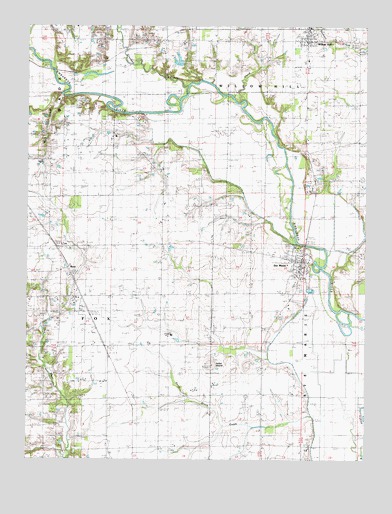
Sainte Marie, IL USGS Topographic Map
Click on map above to begin viewing in our Map Viewer.

This topographic map contains these locations and features:
Feature Name Type Latitude Longitude GNIS ID View Map
Assumption CemeteryCemeteryN38.9234°W88.0289°1923073View Map
Bergbower FarmLocaleN38.9944°W88.0994°2724434View Map
BoosPopulated PlaceN38.9300°W88.1109°422487View Map
Camp CreekStreamN38.9803°W88.0470°405448View Map
Catt School (historical)SchoolN38.9964°W88.0611°405707View Map
Crooked CreekStreamN38.9820°W88.0673°406810View Map
Dallmier School (historical)SchoolN38.9514°W88.0761°406932View Map
Edison CemeteryCemeteryN38.9978°W88.0264°1923104View Map
Indian MoundSummitN38.9023°W88.0564°410869View Map
Kaufmann Cattle FarmLocaleN38.9328°W88.0556°2724431View Map
Kessler School (historical)SchoolN38.9650°W88.0950°411433View Map
Midway School (historical)SchoolN38.9664°W88.0214°413524View Map
Ochs FarmLocaleN38.9272°W88.0764°2724437View Map
Ochs School (historical)SchoolN38.9225°W88.0753°414951View Map
Onion Prairie ChurchChurchN38.9784°W88.0031°415129View Map
Onion Prairie School (historical)SchoolN38.9781°W88.0031°2052840View Map
Pond Grove CreekStreamN38.8878°W88.0198°415998View Map
Pond Grove School (historical)SchoolN38.8867°W88.0375°415999View Map
Reis FarmsLocaleN38.9192°W88.0278°2724510View Map
Richards School (historical)SchoolN38.8937°W88.0864°416592View Map
Richland CreekStreamN38.8753°W88.1089°416604View Map
Saint Mary of the Assumption ChurchChurchN38.9323°W88.0253°2052838View Map
Sainte MariePopulated PlaceN38.9323°W88.0234°419080View Map
Sainte Marie City CemeteryCemeteryN38.9284°W88.0289°1923583View Map
Sainte Marie Elementary SchoolSchoolN38.9295°W88.0261°1815658View Map
Sainte Marie Pilgrim Holiness ChurchChurchN38.9303°W88.0245°2052839View Map
Sainte Marie Post OfficePost OfficeN38.9328°W88.0231°1725228View Map
Sainte Marie Volunteer Fire DepartmentBuildingN38.9335°W88.0235°2681889View Map
Shiloh CemeteryCemeteryN38.9950°W88.0442°1923579View Map
Shiloh ChurchChurchN38.9956°W88.0456°418413View Map
Township of FoxCivilN38.9068°W88.0997°429021View Map
Township of Sainte MarieCivilN38.9032°W88.0016°422229View Map
Township of Willow HillCivilN38.9918°W88.0122°429940View Map
Village of Sainte MarieCivilN38.9300°W88.0277°2399172View Map
Village of Willow HillCivilN38.9958°W88.0218°2399700View Map
Willow HillPopulated PlaceN38.9959°W88.0225°421248View Map
Willow Hill Elementary SchoolSchoolN38.9903°W88.0217°1815662View Map
Willow Hill Post OfficePost OfficeN38.9969°W88.0219°2724425View Map
Willow Hill Volunteer Fire DepartmentBuildingN38.9956°W88.0219°2681876View Map
Wolf CreekStreamN38.9795°W88.1131°421367View Map

Note: Coordinates in the location and feature list above are referenced to NAD83 datum.


Copyright (C) 2008-2025 Ryan Niemi / Sunset Dynamics ... All Rights Reserved