TopoQuest Logo
Do you find TopoQuest useful?
Help keep TopoQuest running and adding new maps/features by donating!
Bitcoin:  19c7KJd3qBynnjoSw5npx9KScwjBe4ifkT
Litecoin:  LXs6TkuXGGXo1vDsWCkWVdjQX94eUKd6ui
Home View Maps Find Maps Find Places Resources & Links


Newville, Pennsylvania Topographic Map

USGS Map Title: Newville, PA
USGS Map MRC: 40077B4
DRG (GeoTIFF) Download: o40077b4.tif


Neighboring USGS Topographic Map Quads:


  Blain, PA  
40077C5
 

  Andersonburg, PA  
40077C4
 

  Landisburg, PA  
40077C3
 

  Newburg, PA  
40077B5
 

  Newville, PA  
40077B4
 

  Plainfield, PA  
40077B3
 

  Shippensburg, PA  
40077A5
 

  Walnut Bottom, PA  
40077A4
 

  Dickinson, PA  
40077A3


Map MRC Location:

N41°
W78°
N41°
W77°
H8 H7 H6 H5 H4 H3 H2 H1
G8 G7 G6 G5 G4 G3 G2 G1
F8 F7 F6 F5 F4 F3 F2 F1
E8 E7 E6 E5 E4 E3 E2 E1
D8 D7 D6 D5 D4 D3 D2 D1
C8 C7 C6 C5 C4 C3 C2 C1
B8 B7 B6 B5 B4 B3 B2 B1
A8 A7 A6 A5 A4 A3 A2 A1
N40°
W78°
N40°
W77°

Newville, PA USGS 1:24K Topographic Map Preview:
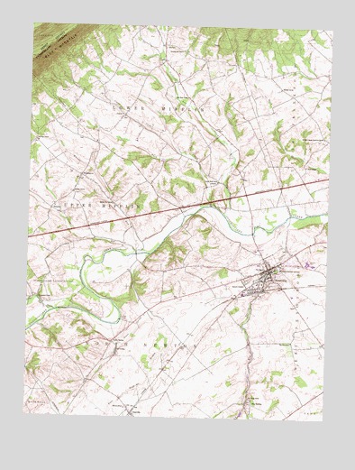
Newville, PA USGS Topographic Map
Click on map above to begin viewing in our Map Viewer.

This topographic map contains these locations and features:
Feature Name Type Latitude Longitude GNIS ID View Map
Back CreekStreamN40.1931°W77.4225°1168557View Map
Bethany ChurchChurchN40.1970°W77.4808°1169343View Map
Big SpringSpringN40.1284°W77.4072°1202163View Map
Big SpringPopulated PlaceN40.1298°W77.4053°1169587View Map
Big Spring CreekStreamN40.1887°W77.3911°1169594View Map
Big Spring SchoolSchoolN40.1318°W77.4067°1169600View Map
Big Spring State Fish HatcheryLocaleN40.1268°W77.4094°1205692View Map
Bluehill SchoolSchoolN40.1756°W77.3828°1169903View Map
Borough of NewvilleCivilN40.1702°W77.4015°1215153View Map
Brandy RunStreamN40.1776°W77.4536°1170163View Map
Bridgewater SchoolSchoolN40.1631°W77.4953°1170247View Map
Bulls Head BranchStreamN40.1604°W77.4505°1170663View Map
CenterLocaleN40.2218°W77.4600°1171421View Map
Center CreekStreamN40.2095°W77.4358°1171435View Map
Cool SpringSpringN40.1718°W77.3936°1202294View Map
Council Bluff SchoolSchoolN40.2004°W77.4205°1172497View Map
Doubling Gap ChurchChurchN40.2423°W77.4355°1173415View Map
Doubling Gap CreekStreamN40.1904°W77.4178°1173416View Map
Friendship Hose Company Station 47BuildingN40.1727°W77.3977°2653066View Map
Gillespie SchoolSchoolN40.2304°W77.3950°1175615View Map
Green SpringPopulated PlaceN40.1493°W77.4639°1176114View Map
Green SpringSpringN40.1448°W77.4622°1202293View Map
Green Spring Church (historical)ChurchN40.1468°W77.4792°1197274View Map
Green Spring CreekStreamN40.1770°W77.4561°1176115View Map
HeberligPopulated PlaceN40.1923°W77.4897°1176735View Map
John Graham Memorial CemeteryCemeteryN40.1726°W77.3961°1178099View Map
McCreaPopulated PlaceN40.2443°W77.4433°1180673View Map
Mount HopePopulated PlaceN40.2131°W77.4967°1197273View Map
Mount Hope SchoolSchoolN40.2137°W77.4972°1181722View Map
NewvillePopulated PlaceN40.1731°W77.3986°1182431View Map
Newville CemeteryCemeteryN40.1690°W77.4083°1182432View Map
Newville Post OfficePost OfficeN40.1744°W77.4012°2772880View Map
Oak Flat SchoolSchoolN40.1495°W77.3889°1182730View Map
OakvillePopulated PlaceN40.1262°W77.4553°1182850View Map
Oakville SchoolSchoolN40.1281°W77.4580°1182851View Map
Pennsylvania State Police Troop T Newville StationBuildingN40.2015°W77.3846°2754580View Map
Prospect CemeteryCemeteryN40.1816°W77.3760°1197272View Map
Saint Peters Upper Frankford ChurchChurchN40.2151°W77.3767°1186687View Map
State Game Lands Number 169ParkN40.1662°W77.4875°1193437View Map
State Road SchoolSchoolN40.2273°W77.4333°1188562View Map
Stouts SchoolSchoolN40.2056°W77.3842°1188823View Map
Three Square Hollow RunStreamN40.1590°W77.4880°1189552View Map
Township of Lower MifflinCivilN40.2411°W77.4339°1216338View Map
Township of North NewtonCivilN40.1438°W77.4445°1216342View Map
WashingtonPopulated PlaceN40.2023°W77.4780°1190619View Map
Whisky RunStreamN40.1779°W77.4508°1191237View Map
Whisky Run SchoolSchoolN40.1931°W77.4642°1191241View Map
Zion ChurchChurchN40.1726°W77.4008°1191978View Map

Note: Coordinates in the location and feature list above are referenced to NAD83 datum.


Copyright (C) 2008-2025 Ryan Niemi / Sunset Dynamics ... All Rights Reserved