TopoQuest Logo
Do you find TopoQuest useful?
Help keep TopoQuest running and adding new maps/features by donating!
Bitcoin:  19c7KJd3qBynnjoSw5npx9KScwjBe4ifkT
Litecoin:  LXs6TkuXGGXo1vDsWCkWVdjQX94eUKd6ui
Home View Maps Find Maps Find Places Resources & Links


Blain, Pennsylvania Topographic Map

USGS Map Title: Blain, PA
USGS Map MRC: 40077C5
DRG (GeoTIFF) Download: o40077c5.tif


Neighboring USGS Topographic Map Quads:


  McVeytown, PA  
40077D6
 

  McCoysville, PA  
40077D5
 

  Spruce Hill, PA  
40077D4
 

  Blairs Mills, PA  
40077C6
 

  Blain, PA  
40077C5
 

  Andersonburg, PA  
40077C4
 

  Doylesburg, PA  
40077B6
 

  Newburg, PA  
40077B5
 

  Newville, PA  
40077B4


Map MRC Location:

N41°
W78°
N41°
W77°
H8 H7 H6 H5 H4 H3 H2 H1
G8 G7 G6 G5 G4 G3 G2 G1
F8 F7 F6 F5 F4 F3 F2 F1
E8 E7 E6 E5 E4 E3 E2 E1
D8 D7 D6 D5 D4 D3 D2 D1
C8 C7 C6 C5 C4 C3 C2 C1
B8 B7 B6 B5 B4 B3 B2 B1
A8 A7 A6 A5 A4 A3 A2 A1
N40°
W78°
N40°
W77°

Blain, PA USGS 1:24K Topographic Map Preview:
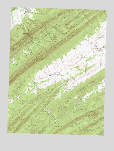
Blain, PA USGS Topographic Map
Click on map above to begin viewing in our Map Viewer.

This topographic map contains these locations and features:
Feature Name Type Latitude Longitude GNIS ID View Map
Alfarata TrailTrailN40.2768°W77.5839°1206515View Map
Bear PondLakeN40.3577°W77.5947°1168901View Map
Beasley TrailTrailN40.2654°W77.5800°1168981View Map
Beavertown RidgeRidgeN40.2920°W77.5336°1169072View Map
Big KnobSummitN40.3579°W77.5464°1169528View Map
Big Knob TrailTrailN40.3592°W77.5553°1206517View Map
BlainPopulated PlaceN40.3384°W77.5125°1169780View Map
Blain CemeteryCemeteryN40.3379°W77.5036°1169781View Map
Blain Fire Company / Blain Ambulance AssociationBuildingN40.3383°W77.5125°2645623View Map
Blain HollowValleyN40.3558°W77.5678°1169783View Map
Blain Post OfficePost OfficeN40.3382°W77.5124°2772605View Map
Blue Knob Lookout TowerTowerN40.3579°W77.5464°1212653View Map
Boiler TrailTrailN40.2534°W77.5347°1206524View Map
Borough of BlainCivilN40.3365°W77.5124°1215522View Map
Bowers RunStreamN40.3245°W77.5244°1170055View Map
Bowman TrailTrailN40.2818°W77.5872°1170069View Map
Browns RunStreamN40.2618°W77.5947°1212879View Map
Buck RidgeRidgeN40.2881°W77.5733°1170532View Map
Burnt TrailTrailN40.3681°W77.5228°1170753View Map
CCC Camp (historical)LocaleN40.3404°W77.5930°1197172View Map
CCC Camp (historical)LocaleN40.2643°W77.5622°1197175View Map
Center RidgeRidgeN40.2829°W77.5467°1171443View Map
Center SquarePopulated PlaceN40.2959°W77.5500°1171459View Map
Cold Spring RunStreamN40.2515°W77.5775°1172162View Map
Conococheague MountainSummitN40.3648°W77.5261°1192293View Map
Conococheague TrailTrailN40.3404°W77.5625°1172357View Map
Cross BarRidgeN40.3684°W77.5339°1172735View Map
Duncan HollowValleyN40.3727°W77.5893°1173596View Map
East WaterfordPopulated PlaceN40.3704°W77.6047°1173900View Map
East Waterford Census Designated PlaceCensusN40.3711°W77.6047°2389449View Map
East Waterford Community Fire Company Station 7BuildingN40.3714°W77.6036°2645866View Map
East Waterford NarrowsLocaleN40.3481°W77.5992°1173902View Map
East Waterford Post OfficePost OfficeN40.3695°W77.6069°2773129View Map
Eby CemeteryCemeteryN40.2912°W77.6047°1206554View Map
Eby RidgeRidgeN40.2940°W77.6125°1173963View Map
End TrailTrailN40.3387°W77.6080°1174252View Map
Fairview ChurchChurchN40.2873°W77.6117°1174516View Map
Fairview SchoolSchoolN40.2879°W77.6105°1197176View Map
Fowler Hollow RunStreamN40.2748°W77.5747°1175085View Map
Fowler Hollow State ParkParkN40.2726°W77.5797°1175084View Map
Gibbons TrailTrailN40.3576°W77.5730°1175583View Map
Hampton TrailTrailN40.3534°W77.5780°1176445View Map
Hickory RidgeRidgeN40.2637°W77.6203°1176972View Map
Horse ValleyValleyN40.3437°W77.5947°1177451View Map
Horse Valley RunStreamN40.3726°W77.6003°1177454View Map
Kansas ValleyValleyN40.3436°W77.5947°1178220View Map
Kansas Valley Park AreaParkN40.3562°W77.5680°1178221View Map
Kansas Valley RunStreamN40.3437°W77.5939°1178222View Map
Keen TrailTrailN40.2693°W77.5242°1206525View Map
Lack Tuscarora Emergency Medical ServicesBuildingN40.3694°W77.6060°2719562View Map
Little GapGapN40.3715°W77.5533°1179551View Map
Little Gap TrailTrailN40.3690°W77.5400°1179554View Map
Little KnobSummitN40.3456°W77.5630°1179580View Map
Mount PleasantPopulated PlaceN40.3190°W77.5450°1204228View Map
Mumper Spring TrailTrailN40.3551°W77.5492°1182081View Map
Narrow Gauge TrailTrailN40.3281°W77.5930°1182166View Map
Negro Clearing TrailTrailN40.3412°W77.5797°1182220View Map
New GermantownPopulated PlaceN40.3090°W77.5697°1182324View Map
Old Blain TrailTrailN40.3629°W77.5164°1206516View Map
Pennsylvania Conservation and Natural Resources District 3 TuscaroraBuildingN40.3031°W77.5891°2645717View Map
Red Corner SchoolSchoolN40.3459°W77.5119°1197173View Map
Red Hill SchoolSchoolN40.3112°W77.5244°1197174View Map
Rising Mountain TrailTrailN40.2668°W77.6030°1206553View Map
Robber HollowValleyN40.3467°W77.5823°1185196View Map
Robber Hollow TrailTrailN40.3529°W77.5830°1185197View Map
Shaeffer RunStreamN40.3006°W77.5097°1187316View Map
Sheriff TrailTrailN40.2570°W77.5133°1187483View Map
Shultz CreekStreamN40.3162°W77.5430°1187630View Map
Shultz RidgeRidgeN40.2762°W77.5553°1187631View Map
Skinner RidgeRidgeN40.2765°W77.6072°1187759View Map
Smith HollowValleyN40.3684°W77.5945°1187875View Map
Telephone TrailTrailN40.3587°W77.5494°1189341View Map
The KettleLocaleN40.3673°W77.5522°1189411View Map
Three Springs ChurchChurchN40.3162°W77.5247°1189545View Map
Township of JacksonCivilN40.3144°W77.5067°1216941View Map
Township of ToboyneCivilN40.2721°W77.5901°1216952View Map
Trostle RidgeRidgeN40.2834°W77.5903°1189821View Map
Turkey Pens TrailTrailN40.2540°W77.5497°1206526View Map
Tuscarora State ForestForestN40.3612°W77.5555°1193566View Map
Tuscarora TrailTrailN40.3629°W77.5686°1189984View Map
Winns GapGapN40.3681°W77.5639°1191604View Map
Winns Gap TrailTrailN40.3634°W77.5617°1191605View Map
Yellow Pine TrailTrailN40.2654°W77.5378°1191880View Map

Note: Coordinates in the location and feature list above are referenced to NAD83 datum.


Copyright (C) 2008-2025 Ryan Niemi / Sunset Dynamics ... All Rights Reserved