TopoQuest Logo
Do you find TopoQuest useful?
Help keep TopoQuest running and adding new maps/features by donating!
Bitcoin:  19c7KJd3qBynnjoSw5npx9KScwjBe4ifkT
Litecoin:  LXs6TkuXGGXo1vDsWCkWVdjQX94eUKd6ui
Home View Maps Find Maps Find Places Resources & Links


Landisburg, Pennsylvania Topographic Map

USGS Map Title: Landisburg, PA
USGS Map MRC: 40077C3
DRG (GeoTIFF) Download: o40077c3.tif


Neighboring USGS Topographic Map Quads:


  Spruce Hill, PA  
40077D4
 

  Ickesburg, PA  
40077D3
 

  Newport, PA  
40077D2
 

  Andersonburg, PA  
40077C4
 

  Landisburg, PA  
40077C3
 

  Shermans Dale, PA  
40077C2
 

  Newville, PA  
40077B4
 

  Plainfield, PA  
40077B3
 

  Carlisle, PA  
40077B2


Map MRC Location:

N41°
W78°
N41°
W77°
H8 H7 H6 H5 H4 H3 H2 H1
G8 G7 G6 G5 G4 G3 G2 G1
F8 F7 F6 F5 F4 F3 F2 F1
E8 E7 E6 E5 E4 E3 E2 E1
D8 D7 D6 D5 D4 D3 D2 D1
C8 C7 C6 C5 C4 C3 C2 C1
B8 B7 B6 B5 B4 B3 B2 B1
A8 A7 A6 A5 A4 A3 A2 A1
N40°
W78°
N40°
W77°

Landisburg, PA USGS 1:24K Topographic Map Preview:
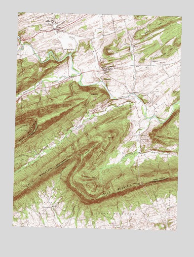
Landisburg, PA USGS Topographic Map
Click on map above to begin viewing in our Map Viewer.

This topographic map contains these locations and features:
Feature Name Type Latitude Longitude GNIS ID View Map
AlindaPopulated PlaceN40.3465°W77.2844°1168152View Map
Baken CreekStreamN40.3293°W77.2839°1198034View Map
Barkley RidgeRidgeN40.2965°W77.3169°1168718View Map
Bells HillSummitN40.3540°W77.3047°1169183View Map
Berrys GapGapN40.2734°W77.3636°1169317View Map
Bixler RunStreamN40.3559°W77.3703°1169683View Map
Borough of LandisburgCivilN40.3430°W77.3057°1215525View Map
BridgeportPopulated PlaceN40.3298°W77.2867°1170240View Map
Egolf AirportAirportN40.3347°W77.2998°1193943View Map
EntlervillePopulated PlaceN40.2626°W77.3458°1203524View Map
Frankford Airport (historical)AirportN40.2509°W77.2830°1193897View Map
Germany RidgeRidgeN40.3726°W77.2592°1192510View Map
Green Valley RunStreamN40.3148°W77.2717°1176128View Map
Hidden Valley Boy Scout CampLocaleN40.3501°W77.3530°1176991View Map
Hidden Valley Boy Scouts East CampLocaleN40.3526°W77.3394°1212657View Map
Kennedy ValleyValleyN40.3232°W77.2840°1178372View Map
Kennedy Valley ChurchChurchN40.3065°W77.3314°1178373View Map
Kennedy Valley SchoolSchoolN40.3140°W77.3164°1197243View Map
LandisburgPopulated PlaceN40.3426°W77.3072°1178854View Map
Landisburg Ambulance AssociationBuildingN40.3441°W77.3053°2719561View Map
Landisburg CemeteryCemeteryN40.3376°W77.3011°1178855View Map
Landisburg Post OfficePost OfficeN40.3426°W77.3082°2772779View Map
Landisburg Volunteer Fire CompanyBuildingN40.3441°W77.3053°2645684View Map
Laurel RunStreamN40.3406°W77.3272°1179004View Map
Laurel Run ChurchChurchN40.3309°W77.3564°1179024View Map
Little Indian HollowValleyN40.3421°W77.2834°1179565View Map
LoysvillePopulated PlaceN40.3656°W77.3444°1180055View Map
Loysville Post OfficePost OfficeN40.3659°W77.3472°2772805View Map
McCabe RunStreamN40.3254°W77.2794°1180605View Map
McClures GapGapN40.2929°W77.3269°1180643View Map
McClures Gap CemeteryCemeteryN40.2613°W77.3458°1180644View Map
McClures Gap ChurchChurchN40.2581°W77.3525°1180645View Map
McClures Gap SchoolSchoolN40.2634°W77.3458°1180646View Map
Metz Airport (historical)AirportN40.3726°W77.3317°1193959View Map
Middle RidgeRidgeN40.2806°W77.3236°1181041View Map
MilltownPopulated PlaceN40.3568°W77.2864°1181285View Map
Montour CreekStreamN40.3365°W77.3100°1181470View Map
Mount DempseySummitN40.3301°W77.3203°1173148View Map
Mount Zion ChurchChurchN40.3304°W77.2719°1181920View Map
Muddy RunStreamN40.3518°W77.3328°1182056View Map
Oak Grove ChurchChurchN40.3051°W77.2794°1182743View Map
Oak Grove SchoolSchoolN40.3029°W77.2780°1214087View Map
OakgrovePopulated PlaceN40.3001°W77.2789°1202080View Map
Pine Hill SchoolSchoolN40.3287°W77.2744°1214089View Map
Quaker HillSummitN40.3306°W77.2528°1184519View Map
Restland CemeteryCemeteryN40.3640°W77.3583°1184947View Map
Round TopSummitN40.3043°W77.2647°1185547View Map
Sheaffer ValleyValleyN40.3419°W77.3311°1187416View Map
Shulls AirportAirportN40.2927°W77.2925°1193924View Map
Spotts KnobSummitN40.3487°W77.2789°1188199View Map
Spring Dale SchoolSchoolN40.3470°W77.2655°1214103View Map
Spruce Bank SchoolSchoolN40.3384°W77.3339°1197242View Map
Stambaugh Farm RunStreamN40.3669°W77.3118°2765007View Map
Stilhouse HollowValleyN40.3365°W77.3310°1188668View Map
Township of SpringCivilN40.3428°W77.2601°1216951View Map
Township of TyroneCivilN40.3221°W77.3369°1216954View Map
Tressler Orphan HomeBuildingN40.3701°W77.3486°1189746View Map
Trout RunStreamN40.2923°W77.3553°1189861View Map
Waggoners GapGapN40.2768°W77.2778°1190465View Map
Welch HillSummitN40.3034°W77.3042°1190796View Map
Wolf HollowValleyN40.3305°W77.3611°1193682View Map

Note: Coordinates in the location and feature list above are referenced to NAD83 datum.


Copyright (C) 2008-2025 Ryan Niemi / Sunset Dynamics ... All Rights Reserved