TopoQuest Logo
Do you find TopoQuest useful?
Help keep TopoQuest running and adding new maps/features by donating!
Bitcoin:  19c7KJd3qBynnjoSw5npx9KScwjBe4ifkT
Litecoin:  LXs6TkuXGGXo1vDsWCkWVdjQX94eUKd6ui
Home View Maps Find Maps Find Places Resources & Links


Newburg, Pennsylvania Topographic Map

USGS Map Title: Newburg, PA
USGS Map MRC: 40077B5
DRG (GeoTIFF) Download: o40077b5.tif


Neighboring USGS Topographic Map Quads:


  Blairs Mills, PA  
40077C6
 

  Blain, PA  
40077C5
 

  Andersonburg, PA  
40077C4
 

  Doylesburg, PA  
40077B6
 

  Newburg, PA  
40077B5
 

  Newville, PA  
40077B4
 

  Roxbury, PA  
40077A6
 

  Shippensburg, PA  
40077A5
 

  Walnut Bottom, PA  
40077A4


Map MRC Location:

N41°
W78°
N41°
W77°
H8 H7 H6 H5 H4 H3 H2 H1
G8 G7 G6 G5 G4 G3 G2 G1
F8 F7 F6 F5 F4 F3 F2 F1
E8 E7 E6 E5 E4 E3 E2 E1
D8 D7 D6 D5 D4 D3 D2 D1
C8 C7 C6 C5 C4 C3 C2 C1
B8 B7 B6 B5 B4 B3 B2 B1
A8 A7 A6 A5 A4 A3 A2 A1
N40°
W78°
N40°
W77°

Newburg, PA USGS 1:24K Topographic Map Preview:
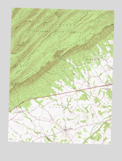
Newburg, PA USGS Topographic Map
Click on map above to begin viewing in our Map Viewer.

This topographic map contains these locations and features:
Feature Name Type Latitude Longitude GNIS ID View Map
Amberson RidgeRidgeN40.2398°W77.6050°1168250View Map
Amberson TrailTrailN40.2101°W77.6089°1206523View Map
Bear HollowValleyN40.1757°W77.5661°1168880View Map
Bore Mill RunStreamN40.1709°W77.5247°1170009View Map
Borough of NewburgCivilN40.1370°W77.5546°1215151View Map
Chestnut Grove SchoolSchoolN40.1904°W77.5497°1211118View Map
Clover Hill SchoolSchoolN40.1462°W77.5867°1211115View Map
Cumberland County LandfillLocaleN40.1458°W77.5028°2725971View Map
Deer Hollow TrailTrailN40.2484°W77.5197°1206527View Map
Dividing Waters TrailTrailN40.2062°W77.5830°1173311View Map
Fenton KnobSummitN40.2390°W77.6014°1174684View Map
First NarrowsGapN40.2454°W77.5694°1174789View Map
Frank E Masland Natural AreaAreaN40.2484°W77.5164°1201698View Map
Hanna CemeteryCemeteryN40.1476°W77.5528°1176463View Map
Hopewell ChurchChurchN40.1534°W77.6075°1177398View Map
Hopewell Newburg Elementary SchoolSchoolN40.1401°W77.5539°1211758View Map
Jackson SchoolSchoolN40.1695°W77.5508°1211116View Map
Koser RunStreamN40.1451°W77.5208°1178656View Map
McKinneyPopulated PlaceN40.1520°W77.6136°1180759View Map
Middle Ridge TrailTrailN40.2384°W77.5294°1206520View Map
Moretown LandfillLocaleN40.1372°W77.5025°2725979View Map
Mount Tabor ChurchChurchN40.1904°W77.5472°1181860View Map
NewburgPopulated PlaceN40.1373°W77.5547°1182384View Map
Newburg - Hopewell Volunteer Fire Company Station 51BuildingN40.1388°W77.5418°2653583View Map
Newburg Post OfficePost OfficeN40.1355°W77.5558°2772866View Map
North Fork TrailTrailN40.2276°W77.5619°1206519View Map
Old Ramp TrailTrailN40.2151°W77.5333°1206521View Map
Peebles RunStreamN40.1434°W77.5175°1183442View Map
Perry Lumber Company TrailTrailN40.2484°W77.6100°1206514View Map
Phoenix TrailTrailN40.2384°W77.5111°1206529View Map
Price KnobSummitN40.2187°W77.6119°1184409View Map
Second NarrowsGapN40.2362°W77.5842°1187213View Map
Shadyside SchoolSchoolN40.1379°W77.5153°1211114View Map
Sherman MountainSummitN40.2201°W77.5883°1193344View Map
Shermans TowerTowerN40.2251°W77.5794°1212658View Map
Shermans TrailTrailN40.2243°W77.6147°1206522View Map
Three Square HollowValleyN40.1997°W77.5525°1189551View Map
Torbett Hollow TrailTrailN40.2479°W77.5155°1206528View Map
Township of HopewellCivilN40.1528°W77.5571°1216335View Map
Township of Upper MifflinCivilN40.1937°W77.5026°1216351View Map
Twig TrailTrailN40.2468°W77.6164°1206513View Map
Wasp HollowValleyN40.1891°W77.5698°1190658View Map
Westfield SchoolSchoolN40.1890°W77.5211°1211117View Map
Zion ChurchChurchN40.1743°W77.5400°1191979View Map

Note: Coordinates in the location and feature list above are referenced to NAD83 datum.


Copyright (C) 2008-2025 Ryan Niemi / Sunset Dynamics ... All Rights Reserved