TopoQuest Logo
Do you find TopoQuest useful?
Help keep TopoQuest running and adding new maps/features by donating!
Bitcoin:  19c7KJd3qBynnjoSw5npx9KScwjBe4ifkT
Litecoin:  LXs6TkuXGGXo1vDsWCkWVdjQX94eUKd6ui
Home View Maps Find Maps Find Places Resources & Links


Nobleton, Wisconsin Topographic Map

USGS Map Title: Nobleton, WI
USGS Map MRC: 45091F6
DRG (GeoTIFF) Download: o45091f6.tif


Neighboring USGS Topographic Map Quads:


  Spooner Lake, WI  
45091G7
 

  Potato Lake, WI  
45091G6
 

  Stone Lake, WI  
45091G5
 

  Sarona, WI  
45091F7
 

  Nobleton, WI  
45091F6
 

  Birchwood, WI  
45091F5
 

  Haugen, WI  
45091E7
 

  Rice Lake North, WI  
45091E6
 

  Mikana, WI  
45091E5


Map MRC Location:

N46°
W92°
N46°
W91°
H8 H7 H6 H5 H4 H3 H2 H1
G8 G7 G6 G5 G4 G3 G2 G1
F8 F7 F6 F5 F4 F3 F2 F1
E8 E7 E6 E5 E4 E3 E2 E1
D8 D7 D6 D5 D4 D3 D2 D1
C8 C7 C6 C5 C4 C3 C2 C1
B8 B7 B6 B5 B4 B3 B2 B1
A8 A7 A6 A5 A4 A3 A2 A1
N45°
W92°
N45°
W91°

Nobleton, WI USGS 1:24K Topographic Map Preview:
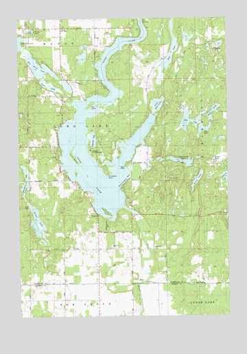
Nobleton, WI USGS Topographic Map
Click on map above to begin viewing in our Map Viewer.

This topographic map contains these locations and features:
Feature Name Type Latitude Longitude GNIS ID View Map
Bass LakeLakeN45.7071°W91.6477°1561256View Map
Berry LakeLakeN45.6818°W91.6436°1561605View Map
Big Devil LakeLakeN45.7296°W91.7375°1561706View Map
Chinty LakeLakeN45.7450°W91.7433°1563033View Map
Christiana PointCapeN45.6952°W91.6974°1563061View Map
Dory's Bog and Hunt Hill State Natural AreaParkN45.7256°W91.7094°2082077View Map
Eliza LakeLakeN45.6833°W91.6267°1564511View Map
Elizabeth LakeLakeN45.6990°W91.7055°1564513View Map
Evergreen ChapelChurchN45.7416°W91.7035°2036721View Map
Fenton LakeLakeN45.6662°W91.7391°1564911View Map
Floyd LakeLakeN45.6903°W91.6335°1565085View Map
Gruenhagen BayBayN45.6833°W91.6891°1565926View Map
Kunz IslandIslandN45.7041°W91.7185°1567662View Map
Lazy Island LakeLakeN45.6898°W91.6524°1567901View Map
Little Devil LakeLakeN45.7401°W91.7494°1568240View Map
Little Mud LakeLakeN45.7137°W91.6667°1568328View Map
Long LakeLakeN45.7062°W91.6715°1568575View Map
Long Lake 82ReservoirN45.6683°W91.6802°1792277View Map
Long Lake ChurchChurchN45.6650°W91.6938°1568587View Map
Long Lake DamDamN45.6683°W91.6802°1792276View Map
Long Lake TownhallBuildingN45.6919°W91.7277°1833851View Map
Loon LakeLakeN45.7033°W91.6395°1568623View Map
MadgePopulated PlaceN45.7458°W91.7238°1577861View Map
McCune LakeLakeN45.6972°W91.7466°1569192View Map
Mud LakeLakeN45.7329°W91.6594°1570000View Map
NobletonPopulated PlaceN45.6791°W91.7027°1570323View Map
Pollywog LakeLakeN45.7389°W91.6294°1571744View Map
Red LakeLakeN45.7108°W91.6335°1572142View Map
Rice IslandIslandN45.7250°W91.7071°1572252View Map
Tomahawk Scout ReservationLocaleN45.6944°W91.7068°1833887View Map
Town of Long LakeCivilN45.6851°W91.7210°1583597View Map
Twin LakeLakeN45.7216°W91.7313°1575786View Map
WAQE-FM (Rice Lake)TowerN45.6666°W91.6685°1582626View Map

Note: Coordinates in the location and feature list above are referenced to NAD83 datum.


Copyright (C) 2008-2025 Ryan Niemi / Sunset Dynamics ... All Rights Reserved