TopoQuest Logo
Do you find TopoQuest useful?
Help keep TopoQuest running and adding new maps/features by donating!
Bitcoin:  19c7KJd3qBynnjoSw5npx9KScwjBe4ifkT
Litecoin:  LXs6TkuXGGXo1vDsWCkWVdjQX94eUKd6ui
Home View Maps Find Maps Find Places Resources & Links


Bellwood, Pennsylvania Topographic Map

USGS Map Title: Bellwood, PA
USGS Map MRC: 40078E3
DRG (GeoTIFF) Download: o40078e3.tif


Neighboring USGS Topographic Map Quads:


  Blandburg, PA  
40078F4
 

  Tipton, PA  
40078F3
 

  Tyrone, PA  
40078F2
 

  Altoona, PA  
40078E4
 

  Bellwood, PA  
40078E3
 

  Spruce Creek, PA  
40078E2
 

  Hollidaysburg, PA  
40078D4
 

  Frankstown, PA  
40078D3
 

  Williamsburg, PA  
40078D2


Map MRC Location:

N41°
W79°
N41°
W78°
H8 H7 H6 H5 H4 H3 H2 H1
G8 G7 G6 G5 G4 G3 G2 G1
F8 F7 F6 F5 F4 F3 F2 F1
E8 E7 E6 E5 E4 E3 E2 E1
D8 D7 D6 D5 D4 D3 D2 D1
C8 C7 C6 C5 C4 C3 C2 C1
B8 B7 B6 B5 B4 B3 B2 B1
A8 A7 A6 A5 A4 A3 A2 A1
N40°
W79°
N40°
W78°

Bellwood, PA USGS 1:24K Topographic Map Preview:
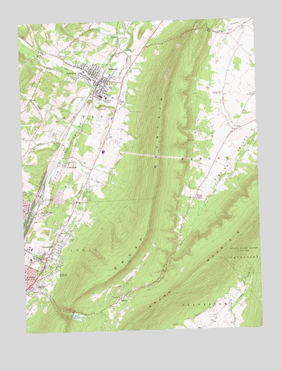
Bellwood, PA USGS Topographic Map
Click on map above to begin viewing in our Map Viewer.

This topographic map contains these locations and features:
Feature Name Type Latitude Longitude GNIS ID View Map
Altoona Mobile Emergency Department AuthorityBuildingN40.6035°W78.3350°2719606View Map
AntisLocaleN40.5753°W78.3506°1200904View Map
Antis CemeteryCemeteryN40.5803°W78.3564°1168340View Map
Beech Grove SchoolSchoolN40.6006°W78.3200°1200869View Map
Bells Gap RunStreamN40.5942°W78.3364°1169182View Map
BellwoodPopulated PlaceN40.6034°W78.3247°1213949View Map
Bellwood Antis Junior Senior High SchoolSchoolN40.5951°W78.3317°1205644View Map
Bellwood DamDamN40.6234°W78.3731°1194949View Map
Bellwood Police DepartmentBuildingN40.6010°W78.3330°2777043View Map
Bellwood Post OfficePost OfficeN40.6005°W78.3324°2777372View Map
Blair Memorial ParkCemeteryN40.6035°W78.3220°2776327View Map
Blair Memorial ParkParkN40.6045°W78.3214°1169794View Map
Borough of BellwoodCivilN40.6009°W78.3343°1214940View Map
Brush MountainSummitN40.5340°W78.3128°1170443View Map
Brush Mountain DamDamN40.5067°W78.3481°1194877View Map
Celestine LocalityLocaleN40.5912°W78.3189°1205152View Map
CulpPopulated PlaceN40.5803°W78.2600°1172819View Map
East AltoonaPopulated PlaceN40.5473°W78.3647°1173718View Map
ElbertaPopulated PlaceN40.5142°W78.3220°1174070View Map
Excelsior Fire Company 1 Bellwood Station 22BuildingN40.5981°W78.3325°2645776View Map
FostoriaPopulated PlaceN40.6184°W78.3206°1175043View Map
GreenwoodPopulated PlaceN40.5359°W78.3575°1176184View Map
Greenwood CemeteryCemeteryN40.5317°W78.3642°1176191View Map
Greenwood Census Designated PlaceCensusN40.5326°W78.3589°2630602View Map
Greenwood Golf CourseLocaleN40.5515°W78.3497°1205780View Map
Greenwood Volunteer Fire Department Station 16BuildingN40.5324°W78.3611°2645774View Map
Homer Gap RunStreamN40.5548°W78.3639°1217355View Map
HuntchinsonsLocaleN40.5767°W78.3714°1200903View Map
Kettle ReservoirReservoirN40.5063°W78.3471°1178422View Map
Lewis M Myers Elementary SchoolSchoolN40.5945°W78.3292°1205645View Map
Logan ValleyValleyN40.5938°W78.3413°1179823View Map
Logan Valley CemeteryCemeteryN40.5931°W78.3275°1179824View Map
Moore SchoolSchoolN40.5042°W78.2742°1200900View Map
Mount Olivet ChurchChurchN40.5137°W78.3239°1181782View Map
Oak Grove SchoolSchoolN40.5490°W78.3464°1201108View Map
PinecroftPopulated PlaceN40.5687°W78.3500°1183923View Map
Pinecroft Volunteer Fire Company Station 23BuildingN40.5687°W78.3512°2645758View Map
Pottsgrove DamDamN40.5251°W78.3564°1194885View Map
Pottsgrove ReservoirReservoirN40.5235°W78.3574°1184351View Map
ReightownPopulated PlaceN40.6023°W78.3333°1184877View Map
Riggles Gap RunStreamN40.5740°W78.3517°1185063View Map
RootsPopulated PlaceN40.6134°W78.3611°1185438View Map
Rose Hill CemeteryCemeteryN40.5194°W78.3663°1185445View Map
Sabbath Rest SchoolSchoolN40.5676°W78.3417°1200868View Map
Saint Johns ChurchChurchN40.5942°W78.2506°1186120View Map
Salem ChurchChurchN40.5773°W78.3558°1186834View Map
Sandy RunStreamN40.5703°W78.3522°1199483View Map
School Number 1 (historical)SchoolN40.5720°W78.2686°1200901View Map
Sickles CornerPopulated PlaceN40.5540°W78.2828°1187645View Map
Sinking Valley Country ClubLocaleN40.5951°W78.2672°1213360View Map
Sinking Valley Lead Zinc MinesMineN40.5792°W78.2689°1206955View Map
Sinking Valley Volunteer Fire Company Station 24BuildingN40.5103°W78.3310°2645848View Map
SkelpPopulated PlaceN40.6198°W78.2681°1187752View Map
Sugar RunStreamN40.5840°W78.3425°1188971View Map
Township of AntisCivilN40.6221°W78.3563°1215957View Map
Township of TyroneCivilN40.5812°W78.2580°1215969View Map

Note: Coordinates in the location and feature list above are referenced to NAD83 datum.


Copyright (C) 2008-2025 Ryan Niemi / Sunset Dynamics ... All Rights Reserved