TopoQuest Logo
Do you find TopoQuest useful?
Help keep TopoQuest running and adding new maps/features by donating!
Bitcoin:  19c7KJd3qBynnjoSw5npx9KScwjBe4ifkT
Litecoin:  LXs6TkuXGGXo1vDsWCkWVdjQX94eUKd6ui
Home View Maps Find Maps Find Places Resources & Links


Tyrone, Pennsylvania Topographic Map

USGS Map Title: Tyrone, PA
USGS Map MRC: 40078F2
DRG (GeoTIFF) Download: o40078f2.tif


Neighboring USGS Topographic Map Quads:


  Houtzdale, PA  
40078G3
 

  Sandy Ridge, PA  
40078G2
 

  Port Matilda, PA  
40078G1
 

  Tipton, PA  
40078F3
 

  Tyrone, PA  
40078F2
 

  Franklinville, PA  
40078F1
 

  Bellwood, PA  
40078E3
 

  Spruce Creek, PA  
40078E2
 

  Alexandria, PA  
40078E1


Map MRC Location:

N41°
W79°
N41°
W78°
H8 H7 H6 H5 H4 H3 H2 H1
G8 G7 G6 G5 G4 G3 G2 G1
F8 F7 F6 F5 F4 F3 F2 F1
E8 E7 E6 E5 E4 E3 E2 E1
D8 D7 D6 D5 D4 D3 D2 D1
C8 C7 C6 C5 C4 C3 C2 C1
B8 B7 B6 B5 B4 B3 B2 B1
A8 A7 A6 A5 A4 A3 A2 A1
N40°
W79°
N40°
W78°

Tyrone, PA USGS 1:24K Topographic Map Preview:
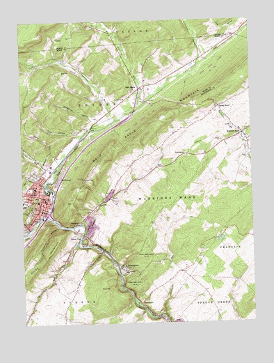
Tyrone, PA USGS Topographic Map
Click on map above to begin viewing in our Map Viewer.

This topographic map contains these locations and features:
Feature Name Type Latitude Longitude GNIS ID View Map
Adams Elementary SchoolSchoolN40.6815°W78.2428°1213813View Map
Altoona Mobile Emergency Department Authority Station 400 Tyrone SubstationBuildingN40.6727°W78.2362°2719607View Map
Anderson CampLocaleN40.7345°W78.2275°1168282View Map
Bald EaglePopulated PlaceN40.7220°W78.1853°1168624View Map
Bald Eagle CemeteryCemeteryN40.7259°W78.1807°2776326View Map
Bald Eagle CreekStreamN40.6695°W78.2378°1192091View Map
Bald Eagle Volunteer Fire Company Station 36BuildingN40.7224°W78.1832°2645196View Map
Baughman CemeteryCemeteryN40.7289°W78.2275°1168816View Map
Baughman HollowValleyN40.7095°W78.2114°1168820View Map
Beck Family CemeteryCemeteryN40.7054°W78.1664°1813172View Map
Big Fill RunStreamN40.7139°W78.1864°1169503View Map
Big SpringSpringN40.6703°W78.2417°1202487View Map
BirminghamPopulated PlaceN40.6478°W78.1953°1169666View Map
Birmingham BridgeBridgeN40.6489°W78.1989°2709854View Map
Birmingham CemeteryCemeteryN40.6477°W78.1938°1813173View Map
Blazing Arrow Hook and Ladder Fire Company Station 33BuildingN40.6727°W78.2362°2645783View Map
Borough of BirminghamCivilN40.6472°W78.1957°1215265View Map
Borough of TyroneCivilN40.6765°W78.2460°1214946View Map
Branstetter CemeteryCemeteryN40.6828°W78.1830°2061746View Map
Bright RunStreamN40.7478°W78.2039°1170251View Map
Burket CemeteryCemeteryN40.6926°W78.1264°1170719View Map
Cabin Ford School (historical)SchoolN40.6745°W78.1570°1201303View Map
California HollowValleyN40.7371°W78.1494°1170887View Map
Cook HollowValleyN40.7039°W78.2189°1172382View Map
Decker RunStreamN40.6887°W78.2306°1173047View Map
Eastlawn CemeteryCemeteryN40.6706°W78.2464°1173921View Map
Elk RunStreamN40.6578°W78.2197°1174125View Map
EyerPopulated PlaceN40.6892°W78.1761°1203539View Map
GardnerPopulated PlaceN40.7437°W78.2295°1203651View Map
Gensimore RunStreamN40.6281°W78.1761°1175522View Map
Grandview CemeteryCemeteryN40.6687°W78.2470°1175946View Map
Gray Memorial FieldCemeteryN40.6809°W78.2450°1192543View Map
Grazier CemeteryCemeteryN40.6940°W78.1904°1958432View Map
Grier SchoolSchoolN40.6459°W78.1933°1176226View Map
Gypsy RunStreamN40.6906°W78.2292°1198849View Map
Hickory Bottom SchoolSchoolN40.7498°W78.1645°1201236View Map
Honest HollowValleyN40.6545°W78.2075°1177340View Map
Hundred SpringsSpringN40.6553°W78.2025°1202304View Map
IronvillePopulated PlaceN40.6576°W78.2164°1177858View Map
Kinch School (historical)SchoolN40.6487°W78.1614°1201233View Map
Laurel RunStreamN40.6817°W78.2372°1179014View Map
Lincoln Elementary SchoolSchoolN40.6756°W78.2408°1213872View Map
Logan Elementary SchoolSchoolN40.6762°W78.2370°1213876View Map
Logan Spring RunStreamN40.6617°W78.2161°1179822View Map
Main SchoolSchoolN40.7156°W78.2039°1201234View Map
McKenrick MillsLocaleN40.6901°W78.2264°1208395View Map
Mountain Orchards SchoolSchoolN40.7117°W78.2472°1201235View Map
NealmontPopulated PlaceN40.6662°W78.2192°1182194View Map
Nearhoff CemeteryCemeteryN40.7126°W78.1400°1813171View Map
NorthwoodPopulated PlaceN40.6853°W78.2297°1182683View Map
Northwood Census Designated PlaceCensusN40.6864°W78.2271°2634249View Map
PenningtonPopulated PlaceN40.6951°W78.1600°1183510View Map
Pine HillSummitN40.6390°W78.2056°1183825View Map
Plummer HollowValleyN40.6651°W78.2296°1184127View Map
Rumberger CemeteryCemeteryN40.7122°W78.1316°2061748View Map
Rural Choice School (historical)SchoolN40.6523°W78.1308°1201232View Map
Schell RunStreamN40.6653°W78.2450°1187073View Map
Shea FieldParkN40.6767°W78.2336°1193336View Map
ShoenbergerPopulated PlaceN40.6334°W78.1858°1204644View Map
Sink RunStreamN40.6753°W78.2331°1187716View Map
Spring MountPopulated PlaceN40.7142°W78.1417°1188249View Map
Spring Mount CemeteryCemeteryN40.7153°W78.1400°1813170View Map
State Game Lands Number 131ParkN40.6409°W78.1920°1193435View Map
State Game Lands Number 278ParkN40.7084°W78.1914°1208397View Map
Steco Airport (historical)AirportN40.7084°W78.1831°1194074View Map
StoverPopulated PlaceN40.6773°W78.2017°1204753View Map
Township of Warriors MarkCivilN40.6893°W78.1470°1216528View Map
TyronePopulated PlaceN40.6706°W78.2386°1190053View Map
Tyrone ForgePopulated PlaceN40.6606°W78.2178°1190055View Map
Tyrone Forge QuarryMineN40.6642°W78.2114°2706954View Map
Tyrone Hospital Radio TowerTowerN40.6901°W78.2164°1208396View Map
Tyrone Neptune Fire Department Station 34BuildingN40.6805°W78.2384°2645046View Map
Tyrone Police DepartmentBuildingN40.6722°W78.2390°2777074View Map
Tyrone Post OfficePost OfficeN40.6717°W78.2383°2777442View Map
VailPopulated PlaceN40.7056°W78.2108°1213606View Map
Vanscoyoc RunStreamN40.7090°W78.1989°1190362View Map
Warriors MarkPopulated PlaceN40.7034°W78.1297°1200127View Map
Warriors Mark Baptist CemeteryCemeteryN40.7029°W78.1274°1958431View Map
Warriors Mark Elementary SchoolSchoolN40.7048°W78.1311°1211546View Map
Warriors Mark Post OfficePost OfficeN40.7032°W78.1287°2779619View Map

Note: Coordinates in the location and feature list above are referenced to NAD83 datum.


Copyright (C) 2008-2024 Ryan Niemi / Sunset Dynamics ... All Rights Reserved