TopoQuest Logo
Do you find TopoQuest useful?
Help keep TopoQuest running and adding new maps/features by donating!
Bitcoin:  19c7KJd3qBynnjoSw5npx9KScwjBe4ifkT
Litecoin:  LXs6TkuXGGXo1vDsWCkWVdjQX94eUKd6ui
Home View Maps Find Maps Find Places Resources & Links


Williamsburg, Pennsylvania Topographic Map

USGS Map Title: Williamsburg, PA
USGS Map MRC: 40078D2
DRG (GeoTIFF) Download: o40078d2.tif


Neighboring USGS Topographic Map Quads:


  Bellwood, PA  
40078E3
 

  Spruce Creek, PA  
40078E2
 

  Alexandria, PA  
40078E1
 

  Frankstown, PA  
40078D3
 

  Williamsburg, PA  
40078D2
 

  Huntingdon, PA  
40078D1
 

  Martinsburg, PA  
40078C3
 

  Entriken, PA  
40078C2
 

  Cassville, PA  
40078C1


Map MRC Location:

N41°
W79°
N41°
W78°
H8 H7 H6 H5 H4 H3 H2 H1
G8 G7 G6 G5 G4 G3 G2 G1
F8 F7 F6 F5 F4 F3 F2 F1
E8 E7 E6 E5 E4 E3 E2 E1
D8 D7 D6 D5 D4 D3 D2 D1
C8 C7 C6 C5 C4 C3 C2 C1
B8 B7 B6 B5 B4 B3 B2 B1
A8 A7 A6 A5 A4 A3 A2 A1
N40°
W79°
N40°
W78°

Williamsburg, PA USGS 1:24K Topographic Map Preview:
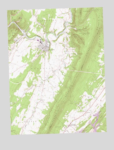
Williamsburg, PA USGS Topographic Map
Click on map above to begin viewing in our Map Viewer.

This topographic map contains these locations and features:
Feature Name Type Latitude Longitude GNIS ID View Map
Arch Spring Natural BridgeArchN40.4392°W78.2042°1679041View Map
Biddle CemeteryCemeteryN40.4315°W78.2014°1169470View Map
Big SpringsSpringN40.4585°W78.2026°1202438View Map
Borough of MarklesburgCivilN40.3821°W78.1697°1215272View Map
Borough of WilliamsburgCivilN40.4625°W78.2042°1214947View Map
Bosler CemeteryCemeteryN40.4137°W78.2061°1170015View Map
Bowers Family CemeteryCemeteryN40.4269°W78.1903°2776329View Map
Brumbaugh CrossingPopulated PlaceN40.3915°W78.1350°1198268View Map
Brumbaugh Historical House (historical)BuildingN40.3929°W78.1403°1207587View Map
CarlimPopulated PlaceN40.4870°W78.1697°1171209View Map
Clover CreekStreamN40.4770°W78.1758°1172028View Map
Cove ForgeLocaleN40.4767°W78.1742°1209041View Map
Cove Forge ChurchChurchN40.4767°W78.1742°1200072View Map
Cove Valley AirportAirportN40.4555°W78.2377°1193990View Map
CovedalePopulated PlaceN40.4826°W78.1728°1172532View Map
David Beck CemeteryCemeteryN40.4070°W78.2095°1172973View Map
Fairview ChurchChurchN40.4212°W78.2047°1174519View Map
Frank CemeteryCemeteryN40.3926°W78.1531°1175133View Map
Franklin ForgePopulated PlaceN40.4729°W78.2350°1201266View Map
GanisterPopulated PlaceN40.4748°W78.2258°1175409View Map
Ganister Blue HoleLakeN40.4694°W78.2376°1175410View Map
Grove CemeteryCemeteryN40.4104°W78.1359°1988409View Map
Hesston SpeedwayLocaleN40.4304°W78.1300°1213227View Map
Hitch Boat LaunchLocaleN40.3759°W78.1642°1213029View Map
Indian Chief RockSummitN40.4734°W78.2081°1201444View Map
James Creek ChurchChurchN40.3906°W78.1383°1177977View Map
James Creek Post OfficePost OfficeN40.3812°W78.1758°2779904View Map
LarkePopulated PlaceN40.4276°W78.2058°1178894View Map
Loop Lookout TowerTowerN40.4976°W78.1322°1213276View Map
MarklesburgPopulated PlaceN40.3831°W78.1731°1192895View Map
Marklesburg Reformed CemeteryCemeteryN40.3774°W78.1800°1184855View Map
Marklesburg Union CemeteryCemeteryN40.3858°W78.1718°1813180View Map
Marklesburg Volunteer Fire Company Station 3BuildingN40.3870°W78.1677°2644974View Map
Martinsburg Sportsmens LodgeBuildingN40.3784°W78.2495°1180506View Map
Old Methodist CemeteryCemeteryN40.4594°W78.2044°2776370View Map
Old Stone Church CemeteryCemeteryN40.3959°W78.1517°1813179View Map
Piney CreekStreamN40.4742°W78.2275°1183935View Map
Point ViewPopulated PlaceN40.4895°W78.2417°1184181View Map
Presbyterian CemeteryCemeteryN40.4580°W78.2006°2776394View Map
Redstone RidgeRidgeN40.4176°W78.1350°1184815View Map
Robeson ExtensionPopulated PlaceN40.4670°W78.1997°1185215View Map
Saint Johns ChurchChurchN40.4059°W78.2136°1186111View Map
Saint Josephs CemeteryCemeteryN40.4527°W78.2115°1186218View Map
Saint Josephs CemeteryCemeteryN40.4645°W78.2052°2776378View Map
Saint Mary's Church CemeteryCemeteryN40.4696°W78.2158°2776381View Map
Saint Marys ChurchChurchN40.4698°W78.2156°1186418View Map
Saint Mathews ChurchChurchN40.3954°W78.1500°1186444View Map
Schmucker CemeteryCemeteryN40.4840°W78.1678°1187089View Map
Schmucker RunStreamN40.4809°W78.1731°1187090View Map
ShelltownPopulated PlaceN40.4565°W78.2064°1187449View Map
ShellytownPopulated PlaceN40.4090°W78.2092°1187452View Map
Shellytown CemeteryCemeteryN40.4055°W78.2128°2776377View Map
Short MountainSummitN40.4909°W78.2331°1187597View Map
Snare RunStreamN40.4737°W78.1714°1187934View Map
Snively CemeteryCemeteryN40.4311°W78.2003°1187942View Map
SparrLocaleN40.4459°W78.1781°1201263View Map
Sparr CemeteryCemeteryN40.4528°W78.1824°2776388View Map
Springfield Bridge (historical)BridgeN40.4654°W78.2408°1201265View Map
Springfield JunctionPopulated PlaceN40.4745°W78.2283°1188297View Map
Stacy KnobLocaleN40.4256°W78.2247°1201264View Map
State Game Lands Number 118ParkN40.4704°W78.1495°1188436View Map
Thompson CemeteryCemeteryN40.4600°W78.1995°2776391View Map
Township of WoodburyCivilN40.4444°W78.2073°1215970View Map
Township RunStreamN40.4876°W78.2431°1189700View Map
Valley View CemeteryCemeteryN40.3961°W78.1404°1190320View Map
WertzPopulated PlaceN40.4556°W78.2472°1190845View Map
WilliamsburgPopulated PlaceN40.4620°W78.1997°1191479View Map
Williamsburg Area AmbulanceBuildingN40.4611°W78.2025°2719572View Map
Williamsburg Area Volunteer Fire Company Station 90BuildingN40.4607°W78.2007°2645066View Map
Williamsburg Borough Police DepartmentBuildingN40.4606°W78.2008°2781057View Map
Williamsburg Post OfficePost OfficeN40.4602°W78.2023°2777448View Map
Williamsburg ReservoirReservoirN40.4720°W78.1593°1191481View Map
Williamsburg ReservoirReservoirN40.4784°W78.1565°1191482View Map
Williamsburg Sportsmens ParkParkN40.4584°W78.1731°1191483View Map
Williamsburg Station DamDamN40.4717°W78.2081°1194841View Map
Williamsburg Station LakeReservoirN40.4717°W78.2081°1194842View Map
Zion ChurchChurchN40.3770°W78.1792°1191986View Map

Note: Coordinates in the location and feature list above are referenced to NAD83 datum.


Copyright (C) 2008-2025 Ryan Niemi / Sunset Dynamics ... All Rights Reserved