TopoQuest Logo
Do you find TopoQuest useful?
Help keep TopoQuest running and adding new maps/features by donating!
Bitcoin:  19c7KJd3qBynnjoSw5npx9KScwjBe4ifkT
Litecoin:  LXs6TkuXGGXo1vDsWCkWVdjQX94eUKd6ui
Home View Maps Find Maps Find Places Resources & Links


Belmont, Mississippi Topographic Map

USGS Map Title: Belmont, MS
USGS Map MRC: 34088E2
DRG (GeoTIFF) Download: o34088e2.tif


Neighboring USGS Topographic Map Quads:


  Paden, MS  
34088F3
 

  Tishomingo, MS  
34088F2
 

  Bishop, AL  
34088F1
 

  Paden SE, MS  
34088E3
 

  Belmont, MS  
34088E2
 

  Pleasant Site, AL  
34088E1
 

  Fulton NE, MS  
34088D3
 

  Red Bay, AL  
34088D2
 

  Halltown, AL  
34088D1


Map MRC Location:

N35°
W89°
N35°
W88°
H8 H7 H6 H5 H4 H3 H2 H1
G8 G7 G6 G5 G4 G3 G2 G1
F8 F7 F6 F5 F4 F3 F2 F1
E8 E7 E6 E5 E4 E3 E2 E1
D8 D7 D6 D5 D4 D3 D2 D1
C8 C7 C6 C5 C4 C3 C2 C1
B8 B7 B6 B5 B4 B3 B2 B1
A8 A7 A6 A5 A4 A3 A2 A1
N34°
W89°
N34°
W88°

Belmont, MS USGS 1:24K Topographic Map Preview:
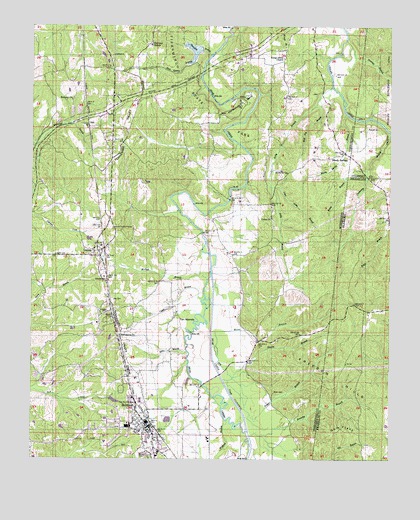
Belmont, MS USGS Topographic Map
Click on map above to begin viewing in our Map Viewer.

This topographic map contains these locations and features:
Feature Name Type Latitude Longitude GNIS ID View Map
Bear Creek FloodwayChannelN34.5370°W88.1875°689865View Map
BelmontPopulated PlaceN34.5098°W88.2092°666799View Map
Belmont Attendance CenterSchoolN34.5095°W88.2164°710755View Map
Belmont Blue Springs ParkParkN34.5145°W88.2164°710756View Map
Belmont BridgeBridgeN34.5243°W88.1845°689867View Map
Belmont CemeteryCemeteryN34.5012°W88.2123°666802View Map
Belmont Church of ChristChurchN34.5082°W88.2095°689868View Map
Belmont Fire DepartmentBuildingN34.5115°W88.2105°2665651View Map
Belmont Methodist ChurchChurchN34.5087°W88.2103°689869View Map
Belmont Police DepartmentBuildingN34.5086°W88.2089°2754286View Map
Belmont Post OfficePost OfficeN34.5083°W88.2083°2768698View Map
Bethany (historical)LocaleN34.6057°W88.2348°710757View Map
Bethany CemeteryCemeteryN34.6043°W88.2353°710758View Map
Bethany ChurchChurchN34.6040°W88.2367°666875View Map
Bill Wood BranchStreamN34.5148°W88.1837°710760View Map
Bloody Spring BranchStreamN34.6001°W88.1406°667275View Map
Bloody SpringsPopulated PlaceN34.5884°W88.1409°691711View Map
Blue SpringsSpringN34.5126°W88.2173°710762View Map
Bridges BranchStreamN34.5540°W88.1878°689878View Map
Brumley BranchStreamN34.5068°W88.1736°115031View Map
Burnt Mill School (historical)SchoolN34.6157°W88.2373°689884View Map
Byram CemeteryCemeteryN34.5326°W88.2006°710767View Map
Camel BranchStreamN34.5473°W88.1898°667957View Map
Carr BranchStreamN34.5287°W88.1956°710768View Map
Chinquapin RidgeRidgeN34.5320°W88.1514°710769View Map
Crossway BranchStreamN34.5945°W88.1250°116911View Map
DennisPopulated PlaceN34.5587°W88.2262°669225View Map
Dennis BridgeBridgeN34.5654°W88.1909°689900View Map
Dennis Lookout TowerTowerN34.5665°W88.2217°711227View Map
Dennis Methodist ChurchChurchN34.5615°W88.2234°710771View Map
Dennis Post OfficePost OfficeN34.5582°W88.2265°2768670View Map
Dennis SchoolSchoolN34.5604°W88.2281°710772View Map
Dennis Volunteer Fire DepartmentBuildingN34.5594°W88.2256°2666069View Map
Dry CreekStreamN34.5437°W88.1884°669425View Map
Emmanuel Baptist ChurchChurchN34.5451°W88.2234°689903View Map
Epps BranchStreamN34.5312°W88.1959°669799View Map
Euclid Academy (historical)SchoolN34.6051°W88.2259°710774View Map
Forest Grove CemeteryCemeteryN34.6154°W88.1625°710777View Map
Forest Grove ChurchChurchN34.6159°W88.1625°670090View Map
Forest Grove SchoolSchoolN34.6140°W88.1617°670091View Map
Forest Grove School (historical)SchoolN34.6143°W88.1623°689909View Map
Foster School (historical)SchoolN34.5690°W88.2256°710778View Map
Fowler BranchStreamN34.5120°W88.1739°118565View Map
Fowler BranchStreamN34.5212°W88.1812°670140View Map
Freedom HillsSummitN34.5276°W88.1564°670193View Map
Gardners Store (historical)LocaleN34.6168°W88.2137°689911View Map
Gum FlatsFlatN34.5093°W88.1414°119476View Map
Gum Springs School (historical)SchoolN34.5143°W88.2162°710780View Map
Hale CemeteryCemeteryN34.5265°W88.2020°710781View Map
Harris BranchStreamN34.5235°W88.1796°119789View Map
Highland (historical)LocaleN34.6209°W88.2084°710783View Map
Highland CemeteryCemeteryN34.6193°W88.2084°689921View Map
Highland ChurchChurchN34.6198°W88.2089°671193View Map
Holly BranchStreamN34.6079°W88.1456°671304View Map
Horseshoe BendBendN34.6029°W88.1775°671478View Map
Joel CemeteryCemeteryN34.5454°W88.2217°671891View Map
Liberty ChurchChurchN34.5512°W88.2242°672457View Map
Lindsey CemeteryCemeteryN34.5431°W88.2231°672507View Map
Little Holly BranchStreamN34.5787°W88.1670°672619View Map
Mad Dog BranchStreamN34.6043°W88.1500°673049View Map
Mann BranchStreamN34.5368°W88.1862°122252View Map
Mann CemeteryCemeteryN34.5193°W88.1650°673112View Map
Mann Post Office (historical)Post OfficeN34.5182°W88.1667°713038View Map
Manns (historical)LocaleN34.5643°W88.2020°689939View Map
Mauldin BranchStreamN34.6165°W88.1881°673248View Map
Mauldin BranchStreamN34.5718°W88.1989°710790View Map
McNutt BranchStreamN34.5534°W88.1878°673421View Map
McRae BranchStreamN34.5909°W88.1787°689942View Map
McRoe BranchStreamN34.5912°W88.1787°673439View Map
Mount Pisgah Methodist Protestant Church (historical)ChurchN34.5440°W88.2212°710793View Map
NeilPopulated PlaceN34.5962°W88.2303°692099View Map
New Providence (historical)LocaleN34.5362°W88.2187°710798View Map
New Providence Baptist ChurchChurchN34.5357°W88.2192°676395View Map
New Providence School (historical)SchoolN34.5351°W88.2181°710799View Map
Old Union CemeteryCemeteryN34.5698°W88.1667°710802View Map
Panther BranchStreamN34.6190°W88.1384°124407View Map
Pittsburg CemeteryCemeteryN34.5479°W88.1981°710807View Map
Pittsburgh (historical)LocaleN34.5515°W88.2056°710806View Map
Pittsburgh School (historical)SchoolN34.5507°W88.2100°710808View Map
Poplar Grove (historical)LocaleN34.5690°W88.2234°689966View Map
Prospect School (historical)SchoolN34.5176°W88.1653°710809View Map
Rock Quarry BranchStreamN34.6173°W88.1934°676769View Map
Rocky BranchStreamN34.5837°W88.1331°125816View Map
Russell CemeteryCemeteryN34.5956°W88.1331°126028View Map
Sardis School (historical)SchoolN34.5445°W88.2134°710811View Map
Scotts Mill (historical)LocaleN34.5712°W88.1989°710813View Map
Southward BridgeBridgeN34.6120°W88.1909°710814View Map
Ten IslandFlatN34.5401°W88.1909°678622View Map
Tishomingo State ParkParkN34.6051°W88.1903°678784View Map
Tishomingo State Park Lake DamDamN34.6218°W88.1900°682742View Map
Town of BelmontCivilN34.5046°W88.2080°2405237View Map
Union Missionary Baptist ChurchChurchN34.5698°W88.1667°679066View Map
Valley (historical)LocaleN34.5590°W88.1795°710604View Map
Valley Grove Volunteer Fire DepartmentBuildingN34.5739°W88.1665°2666021View Map
Valley School (historical)SchoolN34.5593°W88.1800°689998View Map
Wofford BranchStreamN34.5115°W88.1814°679802View Map

Note: Coordinates in the location and feature list above are referenced to NAD83 datum.


Copyright (C) 2008-2025 Ryan Niemi / Sunset Dynamics ... All Rights Reserved