TopoQuest Logo
Do you find TopoQuest useful?
Help keep TopoQuest running and adding new maps/features by donating!
Bitcoin:  19c7KJd3qBynnjoSw5npx9KScwjBe4ifkT
Litecoin:  LXs6TkuXGGXo1vDsWCkWVdjQX94eUKd6ui
Home View Maps Find Maps Find Places Resources & Links


Paden SE, Mississippi Topographic Map

USGS Map Title: Paden SE, MS
USGS Map MRC: 34088E3
DRG (GeoTIFF) Download: o34088e3.tif


Neighboring USGS Topographic Map Quads:


  Altitude, MS  
34088F4
 

  Paden, MS  
34088F3
 

  Tishomingo, MS  
34088F2
 

  Marietta, MS  
34088E4
 

  Paden SE, MS  
34088E3
 

  Belmont, MS  
34088E2
 

  Kirkville, MS  
34088D4
 

  Fulton NE, MS  
34088D3
 

  Red Bay, AL  
34088D2


Map MRC Location:

N35°
W89°
N35°
W88°
H8 H7 H6 H5 H4 H3 H2 H1
G8 G7 G6 G5 G4 G3 G2 G1
F8 F7 F6 F5 F4 F3 F2 F1
E8 E7 E6 E5 E4 E3 E2 E1
D8 D7 D6 D5 D4 D3 D2 D1
C8 C7 C6 C5 C4 C3 C2 C1
B8 B7 B6 B5 B4 B3 B2 B1
A8 A7 A6 A5 A4 A3 A2 A1
N34°
W89°
N34°
W88°

Paden SE, MS USGS 1:24K Topographic Map Preview:
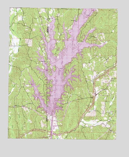
Paden SE, MS USGS Topographic Map
Click on map above to begin viewing in our Map Viewer.

This topographic map contains these locations and features:
Feature Name Type Latitude Longitude GNIS ID View Map
Allen Line (historical)LocaleN34.5709°W88.3278°710754View Map
Allen Line School (historical)SchoolN34.5734°W88.3303°689855View Map
Barnes Store Post Office (historical)Post OfficeN34.5682°W88.2612°713033View Map
Bay Springs (historical)LocaleN34.5265°W88.3223°689861View Map
Bay Springs Church (historical)ChurchN34.5243°W88.3295°689862View Map
Bay Springs LakeReservoirN34.5748°W88.3139°689863View Map
Bay Springs Lock and DamDamN34.5218°W88.3239°689864View Map
Billingsley School (historical)SchoolN34.5651°W88.2920°710761View Map
Bonds CemeteryCemeteryN34.5323°W88.2820°667422View Map
Brumley CemeteryCemeteryN34.5315°W88.3309°706139View Map
Cape Fair (historical)LocaleN34.6098°W88.3375°683627View Map
Cotton Springs CemeteryCemeteryN34.5312°W88.3120°668852View Map
Cotton Springs School (historical)SchoolN34.5301°W88.3103°689896View Map
Crows Neck Recreation and Environmental CenterParkN34.6098°W88.2862°689898View Map
Damsite Recreation AreaParkN34.5307°W88.3167°689899View Map
Dean CemeteryCemeteryN34.5940°W88.2920°669175View Map
East PrentissPopulated PlaceN34.5298°W88.3695°683634View Map
East Prentiss CemeteryCemeteryN34.5309°W88.3670°706154View Map
East Prentiss ChurchChurchN34.5315°W88.3675°669600View Map
East Prentiss School (historical)SchoolN34.5312°W88.3684°706155View Map
Fairview CemeteryCemeteryN34.5084°W88.2562°710775View Map
Fairview ChurchChurchN34.5087°W88.2564°669893View Map
Friendship CemeteryCemeteryN34.5312°W88.3584°706160View Map
Friendship ChurchChurchN34.5301°W88.3595°670247View Map
Friendship School (historical)SchoolN34.5265°W88.3431°706162View Map
Harris Crossing BridgeBridgeN34.5465°W88.3195°710782View Map
Hillside Post Office (historical)Post OfficeN34.5445°W88.3000°713036View Map
Hunt Post Office (historical)Post OfficeN34.5626°W88.3264°713037View Map
Jackson Camp CemeteryCemeteryN34.6129°W88.2989°689931View Map
Jackson Camp Recreation AreaParkN34.5918°W88.3167°689932View Map
Jacksons Camp ChurchChurchN34.6134°W88.2984°671791View Map
Jordan Hill ChurchChurchN34.5479°W88.2637°672026View Map
Jourdan CreekStreamN34.5173°W88.2906°672040View Map
Lacy CreekStreamN34.6190°W88.3664°672242View Map
Mackeys Creek CemeteryCemeteryN34.6140°W88.3300°689937View Map
Mackeys Creek ChurchChurchN34.6148°W88.3295°673044View Map
Mackeys Creek Primitive Baptist Church (historical)ChurchN34.5418°W88.3300°710788View Map
Mackeys Recreation AreaParkN34.5459°W88.3348°683651View Map
McDougal BranchStreamN34.5823°W88.3034°673338View Map
McRae CemeteryCemeteryN34.5148°W88.2645°673436View Map
Mineral Springs School (historical)SchoolN34.5373°W88.2567°710792View Map
Moore CemeteryCemeteryN34.5112°W88.2884°673780View Map
Mount Pleasant CemeteryCemeteryN34.5984°W88.2770°710794View Map
Mount Pleasant ChurchChurchN34.5987°W88.2773°674249View Map
Mount Pleasant School (historical)SchoolN34.5982°W88.2762°689948View Map
Mount Zion ChurchChurchN34.5582°W88.2523°674404View Map
Natchez Trace Recreation AreaParkN34.5737°W88.2959°689951View Map
New Bethel ChurchChurchN34.5712°W88.3281°674592View Map
Old Mackeys Creek CemeteryCemeteryN34.5409°W88.3314°675202View Map
Old Mackies Creek Church (historical)ChurchN34.5412°W88.3320°706197View Map
Pardue (historical)LocaleN34.6001°W88.3325°683658View Map
Perry BranchStreamN34.5195°W88.2592°675619View Map
Phillips CemeteryCemeteryN34.5398°W88.2767°675685View Map
Piney Grove CemeteryCemeteryN34.5740°W88.3317°675893View Map
Piney Grove Recreation AreaParkN34.5834°W88.3375°683660View Map
Riddle CreekStreamN34.5632°W88.3156°676649View Map
Sandy Hook CreekStreamN34.6157°W88.2862°677391View Map
Stevens Arbor School (historical)SchoolN34.6215°W88.2953°689990View Map
Supervisor District 5CivilN34.5219°W88.2817°712104View Map
Trollinger Cemetery (historical)CemeteryN34.5576°W88.3134°678892View Map
Tynes Post Office (historical)Post OfficeN34.5084°W88.3014°713040View Map
Union ChapelChurchN34.5565°W88.2570°679044View Map
Union Chapel CemeteryCemeteryN34.5559°W88.2589°710819View Map

Note: Coordinates in the location and feature list above are referenced to NAD83 datum.


Copyright (C) 2008-2024 Ryan Niemi / Sunset Dynamics ... All Rights Reserved