TopoQuest Logo
Do you find TopoQuest useful?
Help keep TopoQuest running and adding new maps/features by donating!
Bitcoin:  19c7KJd3qBynnjoSw5npx9KScwjBe4ifkT
Litecoin:  LXs6TkuXGGXo1vDsWCkWVdjQX94eUKd6ui
Home View Maps Find Maps Find Places Resources & Links


Halltown, Alabama Topographic Map

USGS Map Title: Halltown, AL
USGS Map MRC: 34088D1
DRG (GeoTIFF) Download: o34088d1.tif


Neighboring USGS Topographic Map Quads:


  Belmont, MS  
34088E2
 

  Pleasant Site, AL  
34088E1
 

  Pleasant Grove, AL  
34087E8
 

  Red Bay, AL  
34088D2
 

  Halltown, AL  
34088D1
 

  Guinn Cross Roads, AL  
34087D8
 

  Shottsville, AL  
34088C2
 

  Vina, AL  
34088C1
 

  Hodges, AL  
34087C8


Map MRC Location:

N35°
W89°
N35°
W88°
H8 H7 H6 H5 H4 H3 H2 H1
G8 G7 G6 G5 G4 G3 G2 G1
F8 F7 F6 F5 F4 F3 F2 F1
E8 E7 E6 E5 E4 E3 E2 E1
D8 D7 D6 D5 D4 D3 D2 D1
C8 C7 C6 C5 C4 C3 C2 C1
B8 B7 B6 B5 B4 B3 B2 B1
A8 A7 A6 A5 A4 A3 A2 A1
N34°
W89°
N34°
W88°

Halltown, AL USGS 1:24K Topographic Map Preview:
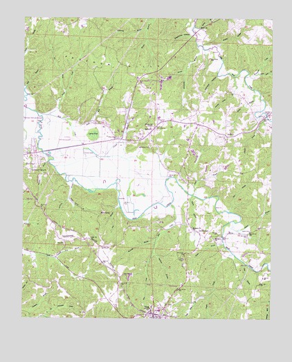
Halltown, AL USGS Topographic Map
Click on map above to begin viewing in our Map Viewer.

This topographic map contains these locations and features:
Feature Name Type Latitude Longitude GNIS ID View Map
Anderson BranchStreamN34.4320°W88.1012°113068View Map
Armstrong BranchStreamN34.4965°W88.0650°113219View Map
Berry CemeteryCemeteryN34.4068°W88.1039°113958View Map
Blue CreekStreamN34.4226°W88.0509°114533View Map
Bolding BranchStreamN34.4882°W88.0295°114683View Map
Boyd Mill BranchStreamN34.4551°W88.1017°114791View Map
Brush CreekStreamN34.4607°W88.1184°115038View Map
Burleson CemeteryCemeteryN34.4104°W88.0261°115236View Map
Burleson ChurchChurchN34.4084°W88.0286°115238View Map
Burleson ChurchChurchN34.4126°W88.0398°115239View Map
BurntoutPopulated PlaceN34.4509°W88.0228°115270View Map
Burntout - Halltown Volunteer Fire DepartmentBuildingN34.4518°W88.0232°2683173View Map
Burntout CemeteryCemeteryN34.4509°W88.0231°136132View Map
Burntout ChurchChurchN34.4515°W88.0245°136133View Map
Burntout Community CenterBuildingN34.4518°W88.0228°136134View Map
Church of ChristChurchN34.3757°W88.0548°141091View Map
Clay BranchStreamN34.3987°W88.0139°116195View Map
Coker ChurchChurchN34.4084°W88.0912°116373View Map
Coker SpurLocaleN34.4051°W88.0856°116375View Map
Community Center ChurchChurchN34.4368°W88.1212°116474View Map
Crooked Neck BranchStreamN34.3998°W88.1084°116889View Map
Cypress PondSwampN34.4509°W88.0900°117000View Map
Deadman HollowValleyN34.4940°W88.0403°117166View Map
Dentons Camp BranchStreamN34.4762°W88.0200°117236View Map
Dry BranchStreamN34.4198°W88.0223°117505View Map
Dry ProngStreamN34.4693°W88.1042°117602View Map
First United ChurchChurchN34.3926°W88.0962°136170View Map
Gilly BranchStreamN34.4712°W88.1237°118965View Map
Gober CemeteryCemeteryN34.3934°W88.0739°119076View Map
Hall BranchStreamN34.4323°W88.0375°119573View Map
HalltownPopulated PlaceN34.4532°W88.0614°119606View Map
Halltown CemeteryCemeteryN34.4468°W88.0625°119607View Map
Hester BranchStreamN34.4062°W88.0236°120003View Map
Hurricane CreekStreamN34.4765°W88.0134°120595View Map
Ivey BranchStreamN34.4220°W88.0767°120725View Map
Jennie BranchStreamN34.4268°W88.0411°120848View Map
Johnson BranchStreamN34.4590°W88.0025°120928View Map
Johnson HollowValleyN34.4762°W88.0284°120953View Map
Jordans MillPopulated PlaceN34.4604°W88.0028°156540View Map
Liberty Hill ChurchChurchN34.4551°W88.0600°152058View Map
Lutts Mill BranchStreamN34.3837°W88.0311°122109View Map
Mailrider BranchStreamN34.4068°W88.0581°122224View Map
Mason BranchStreamN34.4265°W88.0403°122359View Map
McCarley CemeteryCemeteryN34.3993°W88.0856°136205View Map
McClain BranchStreamN34.4023°W88.0595°122472View Map
McKinney BranchStreamN34.4887°W88.0387°152285View Map
McMurray CampLocaleN34.3918°W88.0728°136206View Map
McMurray DamDamN34.3951°W88.0700°132002View Map
McMurray LakeReservoirN34.3951°W88.0700°132003View Map
Mud CreekStreamN34.4595°W88.1134°123544View Map
New Union ChurchChurchN34.4501°W88.0781°123915View Map
Norman BranchStreamN34.4401°W88.1125°123970View Map
Old BurlesonPopulated PlaceN34.4109°W88.0367°124202View Map
Osborn BranchStreamN34.4157°W88.0195°124313View Map
Osborn CemeteryCemeteryN34.4118°W88.0106°124314View Map
Pleasant Ridge Church Number OneChurchN34.4051°W88.1078°136249View Map
Red Bay DivisionCivilN34.4879°W88.0591°165780View Map
Rogers SpringSpringN34.4188°W88.0860°125909View Map
Rogers Spring BranchStreamN34.4251°W88.1023°125910View Map
Sartin Mill BranchStreamN34.4773°W88.0070°126421View Map
Seven PinesPopulated PlaceN34.4740°W88.0687°157040View Map
Shiloh BranchStreamN34.4965°W88.0403°126714View Map
Shiloh ChurchChurchN34.4962°W88.0378°126753View Map
Shoat Mill BranchStreamN34.4784°W88.0445°126794View Map
Taylor CreekStreamN34.4020°W88.0189°127739View Map
Town of VinaCivilN34.3757°W88.0602°2406801View Map
VinaPopulated PlaceN34.3765°W88.0586°153851View Map
Vina Fire DepartmentBuildingN34.3771°W88.0605°2682668View Map
Vina First Baptist ChurchChurchN34.3773°W88.0600°141093View Map
Vina High SchoolSchoolN34.3784°W88.0561°136299View Map
Vina Lookout TowerTowerN34.4001°W88.0439°164443View Map
Vina Post OfficePost OfficeN34.3765°W88.0591°167429View Map
Vina United Methodist ChurchChurchN34.3759°W88.0570°141092View Map
Vinson BranchStreamN34.4457°W88.0953°128468View Map
Vinson LakeLakeN34.4444°W88.0902°128471View Map
Walker BranchStreamN34.4707°W88.0098°128505View Map
Weatherbee CemeteryCemeteryN34.4829°W88.0317°128658View Map

Note: Coordinates in the location and feature list above are referenced to NAD83 datum.


Copyright (C) 2008-2025 Ryan Niemi / Sunset Dynamics ... All Rights Reserved