TopoQuest Logo
Do you find TopoQuest useful?
Help keep TopoQuest running and adding new maps/features by donating!
Bitcoin:  19c7KJd3qBynnjoSw5npx9KScwjBe4ifkT
Litecoin:  LXs6TkuXGGXo1vDsWCkWVdjQX94eUKd6ui
Home View Maps Find Maps Find Places Resources & Links


Fulton NE, Mississippi Topographic Map

USGS Map Title: Fulton NE, MS
USGS Map MRC: 34088D3
DRG (GeoTIFF) Download: o34088d3.tif


Neighboring USGS Topographic Map Quads:


  Marietta, MS  
34088E4
 

  Paden SE, MS  
34088E3
 

  Belmont, MS  
34088E2
 

  Kirkville, MS  
34088D4
 

  Fulton NE, MS  
34088D3
 

  Red Bay, AL  
34088D2
 

  Fulton, MS  
34088C4
 

  Fulton SE, MS  
34088C3
 

  Shottsville, AL  
34088C2


Map MRC Location:

N35°
W89°
N35°
W88°
H8 H7 H6 H5 H4 H3 H2 H1
G8 G7 G6 G5 G4 G3 G2 G1
F8 F7 F6 F5 F4 F3 F2 F1
E8 E7 E6 E5 E4 E3 E2 E1
D8 D7 D6 D5 D4 D3 D2 D1
C8 C7 C6 C5 C4 C3 C2 C1
B8 B7 B6 B5 B4 B3 B2 B1
A8 A7 A6 A5 A4 A3 A2 A1
N34°
W89°
N34°
W88°

Fulton NE, MS USGS 1:24K Topographic Map Preview:
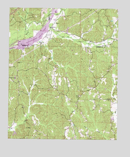
Fulton NE, MS USGS Topographic Map
Click on map above to begin viewing in our Map Viewer.

This topographic map contains these locations and features:
Feature Name Type Latitude Longitude GNIS ID View Map
Allen CemeteryCemeteryN34.4851°W88.3209°710753View Map
Allens ChapelChurchN34.4859°W88.3214°666219View Map
Bethany Church (historical)ChurchN34.4723°W88.2603°689870View Map
Burnt Field CemeteryCemeteryN34.3859°W88.3500°706220View Map
Burnt Fields ChurchChurchN34.3857°W88.3500°667833View Map
Castleberry CemeteryCemeteryN34.4479°W88.3648°668143View Map
Caveness BranchStreamN34.4770°W88.3564°668175View Map
Caveness BridgeBridgeN34.4876°W88.3456°706149View Map
Caveness CemeteryCemeteryN34.4931°W88.3487°668176View Map
Cliff (historical)LocaleN34.4168°W88.3634°706222View Map
Cow BranchStreamN34.4045°W88.2503°668892View Map
Credille DamDamN34.4601°W88.2850°682652View Map
Guy Senter Pond DamDamN34.3818°W88.3000°682616View Map
Liberty CemeteryCemeteryN34.3759°W88.2798°672439View Map
Locust Tree CemeteryCemeteryN34.4423°W88.2814°672759View Map
Locust Tree School (historical)SchoolN34.4501°W88.2620°706246View Map
Lunch (historical)LocaleN34.4426°W88.3206°706247View Map
Mitchell CemeteryCemeteryN34.4629°W88.3023°706251View Map
Moores MillPopulated PlaceN34.4820°W88.3264°673793View Map
Neil Page Pond DamDamN34.3984°W88.2534°682628View Map
New Bethel School (historical)SchoolN34.4840°W88.2689°710797View Map
North Fork Red Bud CreekStreamN34.4715°W88.2570°674948View Map
Northeast Itawamba Volunteer Fire Department Rescue StationBuildingN34.4084°W88.2950°2666011View Map
Old Bethel (historical)LocaleN34.4668°W88.2625°710800View Map
Old Bethel CemeteryCemeteryN34.4645°W88.2637°710801View Map
Old Bethel ChurchChurchN34.4651°W88.2642°675162View Map
Pharr School (historical)SchoolN34.4654°W88.2634°710805View Map
Pounds BranchStreamN34.4837°W88.3562°676283View Map
Red Bud ChurchChurchN34.4784°W88.3175°694525View Map
Red Bud CreekStreamN34.4870°W88.3364°676520View Map
Red Bud School (historical)SchoolN34.4790°W88.3175°710810View Map
Rock CreekStreamN34.4937°W88.3292°676749View Map
Rogers CemeteryCemeteryN34.4518°W88.3292°676816View Map
Ryans Well (historical)LocaleN34.4373°W88.3653°683705View Map
Ryans Well Volunteer Fire Department Station 1BuildingN34.4284°W88.3624°2666009View Map
Salem CemeteryCemeteryN34.4176°W88.2945°706270View Map
Salem ChurchChurchN34.4168°W88.2950°677290View Map
Saucer CreekStreamN34.4745°W88.3562°677427View Map
Saucer Creek CemeteryCemeteryN34.4662°W88.3387°710812View Map
Saucer Creek ChurchChurchN34.4668°W88.3389°677428View Map
Saucer Creek Recreation AreaParkN34.4598°W88.3598°683706View Map
South Fork Red Bud CreekStreamN34.4712°W88.2570°677998View Map
South Tishomingo Fire DepartmentBuildingN34.4711°W88.2621°2666068View Map
South Tishomingo School (historical)SchoolN34.4698°W88.2675°689987View Map
Supervisor District 1CivilN34.3992°W88.2791°711895View Map
Travis South Lake DamDamN34.3801°W88.3684°682613View Map
Voy (historical)LocaleN34.3898°W88.3028°706278View Map
Wadell Lake DamDamN34.4801°W88.3034°682663View Map
Walker House ChurchChurchN34.4132°W88.2598°679270View Map
Warrens Mill (historical)LocaleN34.4765°W88.3667°683679View Map

Note: Coordinates in the location and feature list above are referenced to NAD83 datum.


Copyright (C) 2008-2024 Ryan Niemi / Sunset Dynamics ... All Rights Reserved