TopoQuest Logo
Do you find TopoQuest useful?
Help keep TopoQuest running and adding new maps/features by donating!
Bitcoin:  19c7KJd3qBynnjoSw5npx9KScwjBe4ifkT
Litecoin:  LXs6TkuXGGXo1vDsWCkWVdjQX94eUKd6ui
Home View Maps Find Maps Find Places Resources & Links


Northeast Emmett, Idaho Topographic Map

USGS Map Title: Northeast Emmett, ID
USGS Map MRC: 43116H4
DRG (GeoTIFF) Download: o43116h4.tif


Neighboring USGS Topographic Map Quads:


  Hog Cove Butte, ID  
44116A5
 

  Squaw Butte, ID  
44116A4
 

  Webb Creek, ID  
44116A3
 

  Northwest Emmett, ID  
43116H5
 

  Northeast Emmett, ID  
43116H4
 

  Montour, ID  
43116H3
 

  Southwest Emmett, ID  
43116G5
 

  Southeast Emmett, ID  
43116G4
 

  Pearl, ID  
43116G3


Map MRC Location:

N44°
W117°
N44°
W116°
H8 H7 H6 H5 H4 H3 H2 H1
G8 G7 G6 G5 G4 G3 G2 G1
F8 F7 F6 F5 F4 F3 F2 F1
E8 E7 E6 E5 E4 E3 E2 E1
D8 D7 D6 D5 D4 D3 D2 D1
C8 C7 C6 C5 C4 C3 C2 C1
B8 B7 B6 B5 B4 B3 B2 B1
A8 A7 A6 A5 A4 A3 A2 A1
N43°
W117°
N43°
W116°

Northeast Emmett, ID USGS 1:24K Topographic Map Preview:
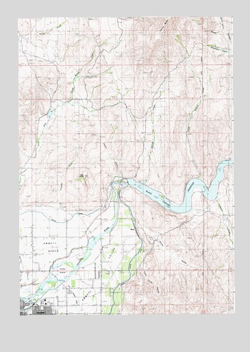
Northeast Emmett, ID USGS Topographic Map
Click on map above to begin viewing in our Map Viewer.

This topographic map contains these locations and features:
Feature Name Type Latitude Longitude GNIS ID View Map
Anderson CreekStreamN43.9224°W116.3854°371234View Map
Black CanyonPopulated PlaceN43.9266°W116.4424°376140View Map
Black Canyon DamDamN43.9304°W116.4365°397443View Map
Black Canyon ReservoirReservoirN43.9300°W116.3868°397445View Map
Bristol CreekStreamN43.9727°W116.4682°371697View Map
Cherry GulchValleyN43.9324°W116.4404°371980View Map
Emmett Police DepartmentBuildingN43.8752°W116.4943°2722417View Map
Emmett Post OfficePost OfficeN43.8752°W116.4935°2766813View Map
Fuller IslandIslandN43.8938°W116.4765°372801View Map
Gem County Ambulance ServiceBuildingN43.8760°W116.4962°2642825View Map
Gem County Sheriff's OfficeBuildingN43.8753°W116.4952°2722426View Map
Haw Creek DamDamN43.9582°W116.4810°398736View Map
Kingman GulchValleyN43.9168°W116.4821°373419View Map
Little ButteSummitN43.9349°W116.4624°373612View Map
Long Hollow CreekStreamN43.9335°W116.3954°373721View Map
Minnis CanyonValleyN43.9938°W116.3807°373975View Map
Picket Corral (historical)LocaleN43.9068°W116.4612°399180View Map
Picket Corral CanyonValleyN43.8946°W116.4290°374387View Map
PlazaPopulated PlaceN43.9113°W116.4329°397046View Map
Plaza Road Bridge Access AreaLocaleN43.9216°W116.4437°401097View Map
Ross IslandIslandN43.8813°W116.4946°374788View Map
Shellrock CanyonValleyN43.9141°W116.4010°375000View Map
Spring CreekStreamN43.9316°W116.4268°375206View Map
Spring GulchValleyN43.9174°W116.4429°375214View Map
Walter Knox Memorial HospitalHospitalN43.8799°W116.4848°2721844View Map
Wood CanyonValleyN43.9866°W116.3751°375983View Map

Note: Coordinates in the location and feature list above are referenced to NAD83 datum.


Copyright (C) 2008-2025 Ryan Niemi / Sunset Dynamics ... All Rights Reserved