TopoQuest Logo
Do you find TopoQuest useful?
Help keep TopoQuest running and adding new maps/features by donating!
Bitcoin:  19c7KJd3qBynnjoSw5npx9KScwjBe4ifkT
Litecoin:  LXs6TkuXGGXo1vDsWCkWVdjQX94eUKd6ui
Home View Maps Find Maps Find Places Resources & Links


Nunica, Michigan Topographic Map

USGS Map Title: Nunica, MI
USGS Map MRC: 43086A1
DRG (GeoTIFF) Download: o43086a1.tif


Neighboring USGS Topographic Map Quads:


  Muskegon East, MI  
43086B2
 

  Sullivan, MI  
43086B1
 

  Ravenna, MI  
43085B8
 

  Grand Haven, MI  
43086A2
 

  Nunica, MI  
43086A1
 

  Coopersville, MI  
43085A8
 

  Port Sheldon, MI  
42086H2
 

  Borculo, MI  
42086H1
 

  Allendale, MI  
42085H8


Map MRC Location:

N44°
W87°
N44°
W86°
H8 H7 H6 H5 H4 H3 H2 H1
G8 G7 G6 G5 G4 G3 G2 G1
F8 F7 F6 F5 F4 F3 F2 F1
E8 E7 E6 E5 E4 E3 E2 E1
D8 D7 D6 D5 D4 D3 D2 D1
C8 C7 C6 C5 C4 C3 C2 C1
B8 B7 B6 B5 B4 B3 B2 B1
A8 A7 A6 A5 A4 A3 A2 A1
N43°
W87°
N43°
W86°

Nunica, MI USGS 1:24K Topographic Map Preview:
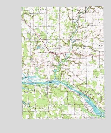
Nunica, MI USGS Topographic Map
Click on map above to begin viewing in our Map Viewer.

This topographic map contains these locations and features:
Feature Name Type Latitude Longitude GNIS ID View Map
Bass RiverStreamN43.0050°W86.0031°620720View Map
Bassriver Post Office (historical)Post OfficeN43.0006°W86.0083°2572980View Map
Black CreekStreamN43.0489°W86.1042°621476View Map
Brandy CreekStreamN43.0822°W86.0473°621892View Map
Conestoga Grand River CampgroundLocaleN43.0306°W86.0339°2573172View Map
Conner PitBayN43.0387°W86.1117°2567985View Map
Connor BayouLakeN43.0369°W86.0997°623709View Map
Crockery CreekStreamN43.0417°W86.0795°624072View Map
Crockery Mobile Home ParkPopulated PlaceN43.0894°W86.1172°2573358View Map
Crockery Township Fire DepartmentBuildingN43.0761°W86.0677°2635974View Map
DeVries DrainCanalN43.0859°W86.0609°624399View Map
Fishermans IslandIslandN43.0124°W86.0146°2568085View Map
Flying-A-Ranch AirportAirportN43.1052°W86.1203°1623908View Map
Fruitport Rest AreaLocaleN43.0931°W86.0981°2571662View Map
Grace ChurchChurchN43.0342°W86.0575°627046View Map
Hat FieldAirportN43.0972°W86.0908°2650906View Map
Interchange 10CrossingN43.0725°W86.0669°2571660View Map
Interchange 9CrossingN43.0742°W86.0828°2571661View Map
Jablonski AirportAirportN43.0819°W86.0909°1624081View Map
Jubb BayouGutN43.0392°W86.0548°629411View Map
NunicaPopulated PlaceN43.0797°W86.0673°633785View Map
Nunica Bible ChurchChurchN43.0803°W86.0664°2573356View Map
Nunica CemeteryCemeteryN43.0764°W86.0917°633786View Map
Nunica Post OfficePost OfficeN43.0769°W86.0667°2573354View Map
Nunica Station (historical)LocaleN43.0783°W86.0686°2573353View Map
Ottawa CenterPopulated PlaceN43.0295°W86.0312°634169View Map
Ottawa Center CemeteryCemeteryN43.0322°W86.0364°2571620View Map
Ottawa Center ChapelChurchN43.0264°W86.0089°634170View Map
Riverside County ParkParkN43.0270°W86.0370°636000View Map
Robinson CemeteryCemeteryN43.0342°W86.0564°2571618View Map
Saint Anthonys ChurchChurchN43.0303°W86.1212°636548View Map
Saint Luke Lutheran ChurchChurchN43.0803°W86.0689°2573357View Map
Saint Michael SchoolSchoolN43.0811°W86.0056°636950View Map
Saint Michael's Catholic ChurchChurchN43.0817°W86.0067°2573051View Map
Saint Michael's CemeteryCemeteryN43.0811°W86.0078°2571623View Map
Terra Verde Golf CourseLocaleN43.0694°W86.0783°2573355View Map
Township of CrockeryCivilN43.0776°W86.0851°1626140View Map

Note: Coordinates in the location and feature list above are referenced to NAD83 datum.


Copyright (C) 2008-2024 Ryan Niemi / Sunset Dynamics ... All Rights Reserved