TopoQuest Logo
Do you find TopoQuest useful?
Help keep TopoQuest running and adding new maps/features by donating!
Bitcoin:  19c7KJd3qBynnjoSw5npx9KScwjBe4ifkT
Litecoin:  LXs6TkuXGGXo1vDsWCkWVdjQX94eUKd6ui
Home View Maps Find Maps Find Places Resources & Links


Coopersville, Michigan Topographic Map

USGS Map Title: Coopersville, MI
USGS Map MRC: 43085A8
DRG (GeoTIFF) Download: o43085a8.tif


Neighboring USGS Topographic Map Quads:


  Sullivan, MI  
43086B1
 

  Ravenna, MI  
43085B8
 

  Casnovia, MI  
43085B7
 

  Nunica, MI  
43086A1
 

  Coopersville, MI  
43085A8
 

  Marne, MI  
43085A7
 

  Borculo, MI  
42086H1
 

  Allendale, MI  
42085H8
 

  Grandville, MI  
42085H7


Map MRC Location:

N44°
W86°
N44°
W85°
H8 H7 H6 H5 H4 H3 H2 H1
G8 G7 G6 G5 G4 G3 G2 G1
F8 F7 F6 F5 F4 F3 F2 F1
E8 E7 E6 E5 E4 E3 E2 E1
D8 D7 D6 D5 D4 D3 D2 D1
C8 C7 C6 C5 C4 C3 C2 C1
B8 B7 B6 B5 B4 B3 B2 B1
A8 A7 A6 A5 A4 A3 A2 A1
N43°
W86°
N43°
W85°

Coopersville, MI USGS 1:24K Topographic Map Preview:
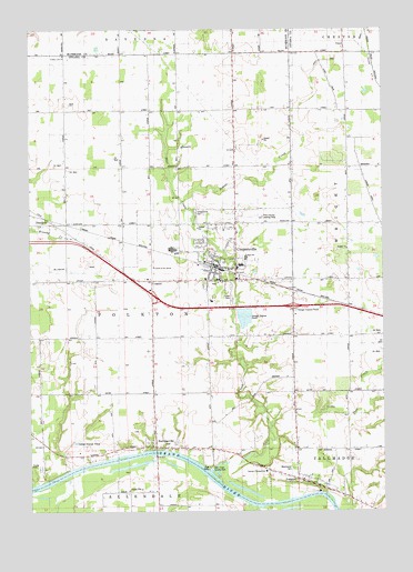
Coopersville, MI USGS Topographic Map
Click on map above to begin viewing in our Map Viewer.

This topographic map contains these locations and features:
Feature Name Type Latitude Longitude GNIS ID View Map
Beaver CreekStreamN43.0811°W85.9464°620910View Map
Boody SchoolSchoolN43.1036°W85.8917°621720View Map
Centennial SchoolSchoolN43.1050°W85.9275°622974View Map
Central Family Worship CenterChurchN43.0658°W85.9353°2573040View Map
Charter Township of PolktonCivilN43.0652°W85.9711°1626923View Map
Church of the SaviorChurchN43.0633°W85.9561°2106576View Map
City of CoopersvilleCivilN43.0658°W85.9341°1626132View Map
CoopersvillePopulated PlaceN43.0639°W85.9348°623797View Map
Coopersville - Polkton Fire DepartmentBuildingN43.0631°W85.9345°2573043View Map
Coopersville - Polkton Fire Department Station 2BuildingN43.0567°W85.9589°2636235View Map
Coopersville Airport (historical)AirportN43.0764°W85.9217°1623847View Map
Coopersville Bible ChurchChurchN43.0592°W85.9306°2573167View Map
Coopersville CemeteryCemeteryN43.0767°W85.9412°623798View Map
Coopersville Christian ChurchChurchN43.0731°W85.9311°2573041View Map
Coopersville Church of ChristChurchN43.0603°W85.9411°2573168View Map
Coopersville East Elementary SchoolSchoolN43.0644°W85.9222°2573046View Map
Coopersville Farm MuseumBuildingN43.0647°W85.9364°2573045View Map
Coopersville High SchoolSchoolN43.0661°W85.9233°2573050View Map
Coopersville Junior High SchoolSchoolN43.0631°W85.9264°2573048View Map
Coopersville Police DepartmentBuildingN43.0628°W85.9339°2573049View Map
Coopersville Post OfficePost OfficeN43.0664°W85.9367°2573044View Map
Coopersville Reformed ChurchChurchN43.0603°W85.9375°2573169View Map
Coopersville Sheriff's OfficeBuildingN43.0631°W85.9345°2737548View Map
Coopersville StationLocaleN43.0636°W85.9350°2573160View Map
Coopersville United Methodist ChurchChurchN43.0647°W85.9331°2573042View Map
Coopersville West Elementary SchoolSchoolN43.0639°W85.9283°2573047View Map
County Line ChurchChurchN43.1184°W85.9875°623885View Map
Deer CreekStreamN43.0103°W85.9370°624454View Map
Deer Creek County ParkParkN43.0103°W85.9167°2106574View Map
DennisonPopulated PlaceN43.0734°W85.9873°624550View Map
Dennison Post Office (historical)Post OfficeN43.0733°W85.9872°2572960View Map
Dennison Station (historical)LocaleN43.0758°W85.9956°2572846View Map
EastmanvillePopulated PlaceN43.0170°W85.9564°625294View Map
Eastmanville CemeteryCemeteryN43.0178°W85.9578°2571624View Map
Eastmanville Post Office (historical)Post OfficeN43.0169°W85.9564°2572885View Map
Eastmanville United Reformed ChurchChurchN43.0169°W85.9569°2573053View Map
Elmwood CemeteryCemeteryN43.0053°W85.8919°2571630View Map
Grace Lutheran ChurchChurchN43.0744°W85.9194°2573166View Map
Grand Country Mobile Home VillagePopulated PlaceN43.0111°W85.9961°2573171View Map
Grove Street ParkParkN43.0650°W85.9292°2573163View Map
Interchange 16CrossingN43.0561°W85.9567°2571659View Map
Interchange 19CrossingN43.0531°W85.9069°2571658View Map
Interurban Depot Historical MarkerParkN43.0639°W85.9536°2571354View Map
Jackson SchoolSchoolN43.0756°W85.9081°629183View Map
LamontPopulated PlaceN43.0086°W85.9062°630108View Map
Lamont Christian Reformed ChurchChurchN43.0081°W85.9033°2573052View Map
Lamont Christian SchoolSchoolN43.0111°W85.9361°2106575View Map
Lamont Post OfficePost OfficeN43.0069°W85.9003°2573249View Map
Lillie SchoolSchoolN43.0461°W85.8887°630392View Map
Little Deer CreekStreamN43.0228°W85.9156°630609View Map
Main Street ParkParkN43.0639°W85.9292°2573162View Map
Maple Hill CemeteryCemeteryN43.0678°W85.8908°2571645View Map
Maplewood CemeteryCemeteryN43.0111°W85.9073°631513View Map
Marshall SchoolSchoolN43.0756°W85.9662°631643View Map
McDearmon SchoolSchoolN43.0742°W85.8873°631867View Map
N Evergreen SchoolSchoolN43.1047°W85.9567°633201View Map
Northeast Ottawa District LibraryBuildingN43.0661°W85.9364°2573165View Map
Randall Street Medical ClinicHospitalN43.0603°W85.9436°2573164View Map
Rankins SchoolSchoolN43.0456°W85.9298°635638View Map
Red SchoolSchoolN43.0228°W85.9359°635721View Map
Timberline Estates Mobile Home ParkPopulated PlaceN43.0556°W85.9286°2573170View Map
Toothacre SchoolSchoolN43.0450°W85.9606°1614962View Map
Veterans ParkParkN43.0592°W85.9336°2573161View Map
WGVU-FM (Allendale)TowerN43.0567°W85.9587°1625650View Map
Wright ChurchChurchN43.0684°W85.8884°1616837View Map

Note: Coordinates in the location and feature list above are referenced to NAD83 datum.


Copyright (C) 2008-2025 Ryan Niemi / Sunset Dynamics ... All Rights Reserved